 www.geodatenkatalog.de (S3L)
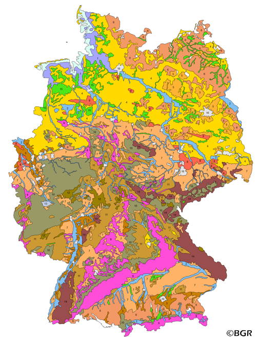
Groups of soil parent material in Germany 1:5,000,000 (WMS)
Web Map Service (WMS) of the map Groups of soil parent material in Germany 1:5,000,000. The presented map at scale 1:5,000,000 shows the distribution of 15 soil parent material groups in Germany with polygons of at least 64 square kilometers. Parent material is the rock, from which soil is formed. It was derived from the landuse use stratified soil map of Germany at scale 1:1,000,000. The version 3.0 of the map is based on the Digital Landscape Model 1:1,000,000 (DLM1000) of the Federal Agency for Cartography and Geodesy.
|
|
Citation proposal
Bundesanstalt für Geowissenschaften und Rohstoffe (BGR) (2007) . Groups of soil parent material in Germany 1:5,000,000 (WMS). https://gdk.gdi-de.org/geonetwork/srv/api/records/30D75B66-DB78-4298-B80F-B7AFBD798DAE |
INSPIRE
Identification
- File identifier
- 30D75B66-DB78-4298-B80F-B7AFBD798DAE XML
- Hierarchy level
- service Service
Online resource
Resource identifier
Encoding
- Format
- png
- Version
- n/a
- Format
- jpeg
- Version
- n/a
- Format
- gif
- Version
- n/a
Projection
Classification of data and services
Classification of data and services
- Service Type
- view
- Coupling Type
- Tight
Coupled resource
Coupled resource
Classification of data and services
- Service Type
- view
- Coupling Type
- Tight
Coupled resource
Coupled resource
Keywords
- GEMET - INSPIRE themes, version 1.0 ( Theme )
-
- Boden
- Soil
- GEMET - Concepts, version 2.4 ( Theme )
-
- Bodenart
- Bodenkarte
- Bodenkunde
- Bodenschutz
- Umweltschutz
- Freies Schlagwort ( Theme )
-
- Bodenausgangsgesteine
- Bodenform
- Bodengesellschaft
- Bodeninformationssystem
- Bodensubstrat
- Bodensystematik
- Bodenübersichtskarte
- Fachinformationssystem
- Geografisches Informationssystem
- infoMapAccessService
- inspireidentifiziert
- opendata
- Spatial scope
-
- National
Other keywords
- Keywords ( Place )
-
- Bundesrepublik Deutschland
Geographic coverage
N
S
E
W
))
Temporal reference
Temporal extent
Temporal extent
- Date ( Publication )
- 2007-01-01
Quality and validity
- Lineage
- BÜK1000 N Version 2.3.
Conformity
Conformity
Conformity
Conformity
Conformity
Conformity
Restrictions on access and use
Restrictions on access and use
- Access constraints
- Allgemeine Geschäftsbedingungen, siehe https://www.bgr.bund.de/AGB - General terms and conditions, see https://www.bgr.bund.de/AGB_en. Die bereitgestellten Informationen sind bei Weiterverwendung wie folgt zu zitieren: Datenquelle: BAG5000 V3.0, (C) BGR, Hannover, 2007.
- Access constraints
- Dieser Datensatz kann gemäß der "Nutzungsbestimmungen für die Bereitstellung von Geodaten des Bundes" (https://sg.geodatenzentrum.de/web_public/gdz/lizenz/geonutzv.pdf) genutzt werden.
- Access constraints
- Dieser Datensatz kann gemäß der "Nutzungsbestimmungen für die Bereitstellung von Geodaten des Bundes" (https://sg.geodatenzentrum.de/web_public/gdz/lizenz/geonutzv.pdf) genutzt werden.
Responsible organization (s)
Contact for the resource
- Organisation name
- Bundesanstalt für Geowissenschaften und Rohstoffe
- fis.bo@bgr.de
- Organisation name
- Bundesanstalt für Geowissenschaften und Rohstoffe (BGR)
Responsible organization (s)
Contact for the resource
- Organisation name
- Bundesanstalt für Geowissenschaften und Rohstoffe
- fis.bo@bgr.de
- Organisation name
- Bundesanstalt für Geowissenschaften und Rohstoffe (BGR)
Metadata information
Contact for the metadata
- Organisation name
- Bundesanstalt für Geowissenschaften und Rohstoffe (BGR)
- Date stamp
- 2024-01-23
- Metadata language
- German
SDS
Conformance class 1: invocable
Access Point URL
Endpoint URL
Technical specification
- Date
- Explanation
- siehe dazu die angegebene Durchführungsbestimmung
Conformance class 2: interoperable
Coordinate reference system
Quality of Service
Access constraints
- Access constraints
- Other restrictions
Limitation
Use constraints
Limitation
- string
- Allgemeine Geschäftsbedingungen, siehe https://www.bgr.bund.de/AGB - General terms and conditions, see https://www.bgr.bund.de/AGB_en. Die bereitgestellten Informationen sind bei Weiterverwendung wie folgt zu zitieren: Datenquelle: BAG5000 V3.0, (C) BGR, Hannover, 2007.
- string
- Dieser Datensatz kann gemäß der "Nutzungsbestimmungen für die Bereitstellung von Geodaten des Bundes" (https://sg.geodatenzentrum.de/web_public/gdz/lizenz/geonutzv.pdf) genutzt werden.
- string
- Dieser Datensatz kann gemäß der "Nutzungsbestimmungen für die Bereitstellung von Geodaten des Bundes" (https://sg.geodatenzentrum.de/web_public/gdz/lizenz/geonutzv.pdf) genutzt werden.
Responsible custodian
Contact for the resource
- Organisation name
- Bundesanstalt für Geowissenschaften und Rohstoffe (BGR)
Conformance class 3: harmonized
Contains Operations
- Operation Name
- GetCapabilities
- Distributed Computing Platforms
- Web services
- Connect Point
- https://services.bgr.de/wms/boden/bag5000/?
Contains Operations
- Operation Name
- GetMap
- Distributed Computing Platforms
- Web services
- Connect Point
- https://services.bgr.de/wms/boden/bag5000/?
Overviews
Provided by

Views
30D75B66-DB78-4298-B80F-B7AFBD798DAE
Access to the portal
Read here the full details and access to the data.
Associated resources
Not available