 www.geodatenkatalog.de (S3L)
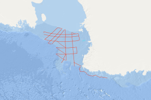
Processed seismic data of Cruise BGR80 1980
During the cruise with S.V. EXPLORA within the Ross Sea on the second marine-geophysical expedition of the Federal Institute for Geosciences and Natural Resources (BGR) to Antarctica, in total 6,745 km of magnetic, gravity and digital reflection seismic lines and additionally 1,400 km gravity lines were acquired in the period from January 10th to March 2nd 1980. On 43 stations sonobuoy refraction measurements have been carried out. The main results are: (1) In the eastern part of the Ross Sea Shelf two striking discontinuities have been identified in the reflection seismics representing gaps in the sediments at the turn-over of the Upper Miocene to the Pliocene (ca. 7 mio years B.P.) and between the Middle and Upper Miocene (ca. 11.5 mio. years B.P.) according to results of DSDP boreholes. (2) In the southern part of the Ross Sea Shelf the basement is uncovered at depths over 700m due to a thrust of the shelf ice recently. (3) A structural unit extends alongside the meridian of 180° separating the Ross Sea into two different geologic regions. This unit is characterised by two basement highs with seismic velocities exceeding 5 km/sec. (4) In relation with the GANOVEX expedition two profiles have been measured off northern Victoria Land which indicate two large faults with a faulting amount of 2 km. Another area is characterised by intrusive and volcanic bodies.
|
|
Citation proposal
. Processed seismic data of Cruise BGR80 1980. https://gdk.gdi-de.org/geonetwork/srv/api/records/30b5e4d5-661b-4837-9126-26d0c312a69f |
INSPIRE
Identification
- File identifier
- 30b5e4d5-661b-4837-9126-26d0c312a69f XML
- Hierarchy level
- Dataset
Online resource
Resource identifier
- code
- 68d180de-f9c6-242f-e8d8-716bba000a36
- Metadata language
- English
- Spatial representation type
- Vector
Encoding
- Format
- Shapefile
- Version
- n/a
Projection
Classification of data and services
- Topic category
-
- Geoscientific information
Classification of data and services
Coupled resource
Coupled resource
Classification of data and services
Coupled resource
Coupled resource
Keywords
- GEMET - INSPIRE themes, version 1.0 ( Theme )
-
- Geologie
- geology
- GEMET - Concepts, version 2.4 ( Theme )
-
- geophysics
- Geophysik
- raw material
- Rohstoff
Other keywords
- Keywords ( Theme )
-
- Marine geology
- Meeresgeologie
- Seismics
- Seismik
- Two-dimensional seismic reflection
- zweidimensionale Reflektionsseismik
- Keywords ( Place )
-
- Ross Sea
- Ross-Meer
Geographic coverage
N
S
E
W
))
Temporal reference
Temporal extent
Temporal extent
- Date ( Creation )
- 1980-03-02
Quality and validity
- Lineage
- During the period from 10th January to 2nd March 1980 BGR acquired seismic lines in the Ross Sea. The lines BGR80-005 and BGR80-006 consist of raw data. The lines BGR80-001, BGR80-002, BGR80-003, BGR80-004, BGR80-007A, BGR80-007B, BGR80-008A, BGR80-008B, BGR80-009, BGR80-010, BGR80-011, BGR80-100, BGR80-101, BGR80-102, BGR80-103, BGR80-104, BGR80-105, BGR80-106, BGR80-107, BGR80-108, BGR80-109 and BGR80-110 are stacked data.
Conformity
Conformity
Conformity
Conformity
Conformity
Conformity
- Explanation
- siehe dazu die angegebene Durchführungsbestimmung
Restrictions on access and use
- Access constraints
- Allgemeine Geschäftsbedingungen, siehe http://www.bgr.bund.de/AGB - General terms and conditions, see http://www.bgr.bund.de/AGB_en. Die bereitgestellten Informationen sind bei Weiterverwendung wie folgt zu zitieren: Datenquelle: BGR80 1980, (c) BGR, Hannover, 2019
Restrictions on access and use
Responsible organization (s)
Contact for the resource
- Organisation name
- Federal Institute for Geosciences and Natural Resources
- Marine_Seismik@bgr.de
Responsible organization (s)
Contact for the resource
- Organisation name
- Federal Institute for Geosciences and Natural Resources
- Marine_Seismik@bgr.de
Metadata information
Contact for the metadata
- Organisation name
- Bundesanstalt für Geowissenschaften und Rohstoffe (BGR)
- Date stamp
- 2023-11-14
- Metadata language
- English
- Character set
- UTF8
SDS
Conformance class 1: invocable
Access Point URL
Endpoint URL
Technical specification
Conformance class 2: interoperable
Coordinate reference system
Quality of Service
Access constraints
Limitation
Use constraints
Limitation
Responsible custodian
Contact for the resource
Conformance class 3: harmonized
Overviews
Provided by

Views
30b5e4d5-661b-4837-9126-26d0c312a69f
Access to the portal
Read here the full details and access to the data.
Associated resources
Not available