 www.geodatenkatalog.de (S3L)
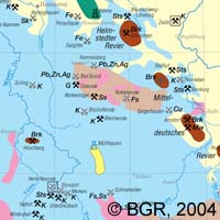
Geoscientific Map of Germany 1:2,000,000 - Important deposits
The series "Geoscience Map of Germany 1: 2 000 000" contains easily comprehensible maps on various topics. The base map "Geology" shows Germany and the adjacent areas in 30 units, differentiated by the formation age. In addition, areas with igneous and metamorphic (formed by shaping) rocks are reported. 5 different types of lines provide an overview of fracture zones in the subsurface. In addition, the expansions of the last ice age are included. A schematic cross section through the surface from south to north shows the structure of the older basement and its cover by younger rocks. It is available in two versions: one with a simple topography and once, for better orientation, with the network of interstate highways. The map "Important deposits" shows deposits and mines of energy raw materials, metal materials, industrial minerals and salts based on a simplified, time-structured geology within Germany.
|
|
Citation proposal
(2004) . Geoscientific Map of Germany 1:2,000,000 - Important deposits. https://gdk.gdi-de.org/geonetwork/srv/api/records/31065A30-E2D3-4B2C-AD54-02B52290E532 |
INSPIRE
Identification
- File identifier
- 31065A30-E2D3-4B2C-AD54-02B52290E532 XML
- Hierarchy level
- dataset Dataset
Online resource
Resource identifier
- code
- 6C84BC0F-DCD0-4CE2-8794-7CA1E3C32BE4
- Metadata language
- ger German
- Spatial representation type
- Grid
Encoding
- Format
- Version
- n/a
Projection
Classification of data and services
- Topic category
-
- Geoscientific information
Classification of data and services
Coupled resource
Coupled resource
Classification of data and services
Coupled resource
Coupled resource
Keywords
- GEMET - INSPIRE themes, version 1.0 ( Theme )
-
- Geologie
- Geology
- GEMET - Concepts, version 2.4 ( Theme )
-
- Tectonic
- Tektonik
Other keywords
- Keywords ( Theme )
-
- Eiszeiten
- GK2000
- Stratigraphie
- opendata
- Keywords ( Place )
-
- Deutschland
Geographic coverage
N
S
E
W
))
Temporal reference
Temporal extent
Temporal extent
- Date ( Publication )
- 2004-09-30
Quality and validity
- Lineage
- -
- Denominator
- 2000000
Conformity
Conformity
Conformity
Conformity
Conformity
Conformity
- Explanation
- siehe dazu die angegebene Durchführungsbestimmung
Restrictions on access and use
- Access constraints
- Allgemeine Geschäftsbedingungen, s. https://www.bgr.bund.de/agb - General Terms and Conditions, s. https://www.bgr.bund.de/agb_en
- Access constraints
- Dieser Datensatz kann gemäß der "Nutzungsbestimmungen für die Bereitstellung von Geodaten des Bundes" (https://sg.geodatenzentrum.de/web_public/gdz/lizenz/geonutzv.pdf) genutzt werden.
- Access constraints
- {"id": "geoNutz/20130319", "name": "Nutzungsbestimmungen für die Bereitstellung von Geodaten des Bundes", "url": "https://sg.geodatenzentrum.de/web_public/gdz/lizenz/geonutzv.pdf", "quelle": "Bundesanstalt für Geowissenschaften und Rohstoffe (BGR)"}
Restrictions on access and use
Responsible organization (s)
Contact for the resource
- Organisation name
- Bundesanstalt für Geowissenschaften und Rohstoffe
- geologie.daten@bgr.de
Responsible organization (s)
Contact for the resource
- Organisation name
- Bundesanstalt für Geowissenschaften und Rohstoffe
- geologie.daten@bgr.de
Metadata information
Contact for the metadata
- Organisation name
- Bundesanstalt für Geowissenschaften und Rohstoffe (BGR)
- Date stamp
- 2024-07-11
- Metadata language
- German
- Character set
- utf8 UTF8
SDS
Conformance class 1: invocable
Access Point URL
Endpoint URL
Technical specification
Conformance class 2: interoperable
Coordinate reference system
Quality of Service
Access constraints
Limitation
Use constraints
Limitation
Responsible custodian
Contact for the resource
Conformance class 3: harmonized
Overviews
Provided by

Views
31065A30-E2D3-4B2C-AD54-02B52290E532
Access to the portal
Read here the full details and access to the data.
Associated resources
Not available