 www.geodatenkatalog.de (S1F)
bDOM - bildbasiertes Digitales Oberflächenmodell -
Das bildbasierte digitale Oberflächenmodell (bDOM) beschreibt höhenmäßig die Erdoberfläche mit allen natürlichen (z.B. Vegetation) und künstlichen Objekten (z.B. Bauwerke). Das bDOM liegt in Form eines gleichmäßigen Rasters mit einer Rasterweite von einem Meter im Blattschnitt 2 km x 2km vor.
|
|
Citation proposal
(2024) . bDOM - bildbasiertes Digitales Oberflächenmodell -. https://gdk.gdi-de.org/geonetwork/srv/api/records/31a76562-db0f-339d-879d-3b2c2b898c0e |
Simple
Identification info
- Date ( Creation )
- 2020-12-14
- Date ( Publication )
- 2024-06-12
- Date ( Revision )
- 2024-03-08
- Presentation form
- Digital map
Point of contact
Point of contact
- Keywords ( Theme )
-
- inspireidentifiziert
- open data
- opendata
- Karten
- Geodaten
- Berlin
- bDOM
- DOM
- ATKIS
- Höhenmodell
- Keywords
-
- infoMapAccessService
- Access constraints
- Other restrictions
- Use constraints
- Other restrictions
- Other constraints
- Für die Nutzung der Daten ist die Datenlizenz Deutschland - Zero - Version 2.0 anzuwenden. Die Lizenz ist über https://www.govdata.de/dl-de/zero-2-0 abrufbar.
- Other constraints
- { "id": "dl-zero-de/2.0" , "name": "Datenlizenz Deutschland - Zero - Version 2.0", "url": "https://www.govdata.de/dl-de/zero-2-0" }
- Service Type
- view
- Service Version
- OGC:WMS 1.0.0
- Service Version
- OGC:WMS 1.1.0
- Service Version
- OGC:WMS 1.1.1
- Service Version
- OGC:WMS 1.3.0
N
S
E
W
))
- Extent type code
- true
- Geographic identifier
- 110000000000
- Coupling Type
- Tight
Contains Operations
- Operation Name
- GetCapabilities
- Distributed Computing Platforms
- Web services
- Connect Point
- https://gdi.berlin.de/services/wms/bdom
- Reference system identifier
- http://www.opengis.net/def/crs/EPSG/0/25833
- Distribution format
-
- Text/HTML (4.01 )
- OnLine resource
-
GetCapabilities Aufruf des WMS mit maschinenlesbarer Antwort
GetCapabilities Aufruf des WMS mit maschinenlesbarer Antwort
- OnLine resource
-
Aufruf des Geoportals Berlin mit Darstellung der Karte und weiterer Metadaten
Aufruf des Geoportals Berlin mit Darstellung der Karte und weiterer Metadaten
- OnLine resource
-
Inhaltliche Beschreibung
Inhaltliche Beschreibung
- Hierarchy level
- Service
- Other
- Dienst
Conformance result
- Date ( Publication )
- 2009-10-20
- Explanation
- see referenced specification
- Pass
- true
gmd:MD_Metadata
- File identifier
- 31a76562-db0f-339d-879d-3b2c2b898c0e XML
- Metadata language
- German
- Character set
- UTF8
- Hierarchy level
- Service
- Hierarchy level name
- bDOM - bildbasiertes Digitales Oberflächenmodell - Dienst
- Date stamp
- 2025-03-06T12:26:03
- Metadata standard name
- ISO 19115/19119 – BE
- Metadata standard version
- 1.0.0
Overviews
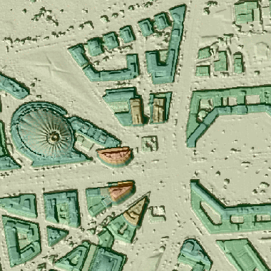
Vorschaugrafik
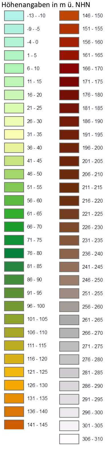
Legende
Provided by

Views
31a76562-db0f-339d-879d-3b2c2b898c0e
Access to the portal
Read here the full details and access to the data.
Associated resources
Not available