 www.geodatenkatalog.de (S3L)
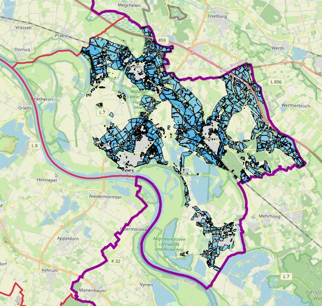
LEP/RP Vorrangflächen Rees
Der Layer „Vorrang Flächen“ stellt für die Kommune Rees, die vorzugsweise zu nutzende Fläche für raumbedeutsame Freiflächenphotovoltaikanlagen entsprechend Landesentwicklungsplans dar.
Die Daten stammen vom Energieatlas des Landesamtes für Natur, Umwelt und Verbraucherschutz Nordrhein-Westfalen und sind pro Kommune ausgewertet.
|
|
Citation proposal
(2024) . LEP/RP Vorrangflächen Rees. Kreis Kleve - Der Landrat https://gdk.gdi-de.org/geonetwork/srv/api/records/327f9417-2154-4d34-b5b0-6f80b2ecc135 |
INSPIRE
Identification
- File identifier
- 327f9417-2154-4d34-b5b0-6f80b2ecc135 XML
- Hierarchy level
- dataset Dataset
Online resource
Resource identifier
- Metadata language
- German
Encoding
Projection
Classification of data and services
- Topic category
-
- Planning cadastre
Classification of data and services
Coupled resource
Coupled resource
Classification of data and services
Coupled resource
Coupled resource
Keywords
- UMTHES Thesaurus ( Theme )
- GEMET - Concepts, version 3.1 ( Theme )
Other keywords
- Keywords
-
- Kreis Kleve
- Kleve
- NW
- NRW
- Nordrhein-Westfalen
- Geoportal
- 051540004004
- PV
- Solar
- Modulfläche
- Energieatlas
- Leistung
- Energien
- Erneuerbare
- potenziell
- Photovoltaikanlage
- Freiflächen
- Vorrangflächen
- LEP/RP
- Landesentwicklungsplan
- Rees
- opendata
- Keywords ( Theme )
-
- ENER
Geographic coverage
N
S
E
W
))
Temporal reference
Temporal extent
Temporal extent
- Date ( Publication )
- 2024-05-11T00:00:00.000+02:00
Quality and validity
- Lineage
-
Bundesnetzagentur - Anlagenregister zu den Erneuerbaren Energien
Übertragungsnetzbetreiber Amprion GmbH und TenneT B V - Meldedaten nach EEG
Conformity
Conformity
Conformity
Conformity
Conformity
Conformity
Restrictions on access and use
- Access constraints
- Datenlizenz Deutschland - Zero - Version 2.0 [https://www.govdata.de/dl-de/zero-2-0]
- Access constraints
- {"id":"dl-zero-de/2.0","name":"Datenlizenz Deutschland – Zero – Version 2.0","url":"https://www.govdata.de/dl-de/zero-2-0","quelle":""}
Restrictions on access and use
Responsible organization (s)
Contact for the resource
- Organisation name
- Kreis Kleve - Der Landrat
- info@kreis-kleve.de
- Organisation name
- Kreis Kleve - Abt. Kataster- und Vermessung - Produktbereich GeoInformation (GIS)
Responsible organization (s)
Contact for the resource
- Organisation name
- Kreis Kleve - Der Landrat
- info@kreis-kleve.de
- Organisation name
- Kreis Kleve - Abt. Kataster- und Vermessung - Produktbereich GeoInformation (GIS)
Metadata information
Contact for the metadata
- Organisation name
- Kreis Kleve - Abt. Kataster- und Vermessung - Produktbereich GeoInformation (GIS)
- Date stamp
- 2025-02-26
- Metadata language
- German
SDS
Conformance class 1: invocable
Access Point URL
Endpoint URL
Technical specification
Conformance class 2: interoperable
Coordinate reference system
Quality of Service
Access constraints
Limitation
Use constraints
Limitation
Responsible custodian
Contact for the resource
Conformance class 3: harmonized
Overviews
Vorrangflächen Rees
Provided by

Views
327f9417-2154-4d34-b5b0-6f80b2ecc135
Access to the portal
Read here the full details and access to the data.
Associated resources
Not available