 www.geodatenkatalog.de (S3L)
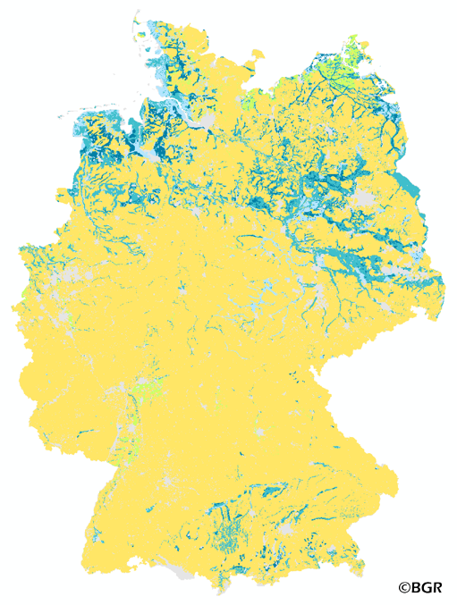
Groundwater levels in Germany
The map of the groundwater influence on soils in Germany gives an overview of depth of groundwater below the surface. Soils that are influenced by groundwater usually have a limited crop yield. The map shows the classified depth of the groundwater. The ground water level is derived from profile data of the landuse stratified soil map of Germany at scale 1:1,000,000. The method is published in the Bodenkundliche Kartieranleitung 5 (2005) and in the documentation of "Ad-hoc-AG Boden" (representing the soil experts of the geological services of the German federal states). The land use information is derived from the CORINE Land Cover data set (2006).
|
|
Citation proposal
(2015) . Groundwater levels in Germany. https://gdk.gdi-de.org/geonetwork/srv/api/records/33b088ba-49e9-4186-a9ef-80dee2f92586 |
Simple
- Alternate title
- GWS1000_250
- Date ( Creation )
- 2014-03-21
- Date ( Publication )
- 2015-08-03
- Edition
- Version 1.0
- Identifier
- 3077cf0d-c462-4ff5-9b64-1db6a5847e68
Author
- Status
- completed Completed
Point of contact
Bundesanstalt für Geowissenschaften und Rohstoffe (BGR)
-
Stegger, Ulrich
Stilleweg 2
Hannover
30655
DE
- GEMET - Concepts, version 2.4 ( Theme )
-
- Boden
- Bodenkarte
- Grundwasser
- vernässter Boden
- GEMET - INSPIRE themes, version 1.0 ( Theme )
-
- Boden
- Soil
- SGD-Liste ( Theme )
-
- Grundwasserflurabstand
- Grundwasseroberfläche
- Freies Schlagwort ( Theme )
-
- MNGW
- mittlerer Grundwassertiefstand
- Hydromorphie
- Vernässung
- Keywords ( Place )
-
- Bundesrepublik Deutschland
- Access constraints
- Other restrictions
- Use constraints
- Other restrictions
- Other constraints
- Allgemeine Geschäftsbedingungen, siehe https://www.bgr.bund.de/AGB - General terms and conditions, see https://www.bgr.bund.de/AGB_en. Die bereitgestellten Informationen sind bei Weiterverwendung wie folgt zu zitieren: Datenquelle: GWS1000_250 V1.0, (c) BGR, Hannover, 2015.
- Spatial representation type
- Grid
- Denominator
- 1000000
- Metadata language
- German
- Character set
- UTF8
- Topic category
-
- Geoscientific information
N
S
E
W
))
- Geographic identifier
- Regionalschlüssel / 000000000000
- Distribution format
-
- GeoTIFF (n/a )
- Transfer size
- 2
- OnLine resource
-
GWS1000_250 (GeoTIFF)
GWS1000_250 im Format GeoTIFF
- OnLine resource
-
Karte im BGR-Geoviewer
Karte im BGR-Geoviewer
- Hierarchy level
- Dataset
Conformance result
- Date ( Publication )
- 2010-12-08
- Explanation
- siehe dazu die angegebene Durchführungsbestimmung
- Statement
- Bodendaten aus BÜK1000N V2.31 (BGR), Landnutzungsdaten aus Corine Land Cover 2006 (UBA/DLR).
gmd:MD_Metadata
- File identifier
- 33b088ba-49e9-4186-a9ef-80dee2f92586 XML
- Metadata language
- German
- Character set
- UTF8
- Hierarchy level
- Dataset
- Hierarchy level name
- Boden
- Date stamp
- 2023-08-22
- Metadata standard name
- INSPIRE Metadata Implementing Rules: Technical Guidelines based on EN ISO 19115 and EN ISO 19119
- Metadata standard version
- n/a
Point of contact
Overviews
Provided by

Views
33b088ba-49e9-4186-a9ef-80dee2f92586
Access to the portal
Read here the full details and access to the data.
Associated resources
Not available