 www.geodatenkatalog.de (S1L)
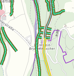
Gewässerrandstreifen - Fließgewässer
Fließgewässernetz 1:25.000 mit Klassifizierung, ob ein Gewässerrandstreifen nach Art. 16 BayNatSchG notwendig ist. Zusätzlich wurden die Gewässer, für die ggf. ein Gewässerrandstreifen aufgrund der Hangneigung anzulegen ist (§38a WHG) kenntlich gemacht. Die Gewässer werden in drei Kategorien („[Gewässerrandstreifen] erforderlich nach Art. 16 BayNatSchG, ggf. erforderlich nach §38a WHG je nach Hangneigung“, "ggf. erforderlich nach §38a WHG je nach Hangneigung" und „in Überprüfung“) dargestellt.
|
|
Citation proposal
. Gewässerrandstreifen - Fließgewässer. https://gdk.gdi-de.org/geonetwork/srv/api/records/34725571-6de5-494f-aeaf-2db22a1c468b |
INSPIRE
Identification
- File identifier
- 34725571-6de5-494f-aeaf-2db22a1c468b XML
- Hierarchy level
- dataset Dataset
Online resource
Resource identifier
- Metadata language
- German
- Spatial representation type
- Vector
Encoding
- Format
- GDB
Projection
Classification of data and services
- Topic category
-
- Inland waters
- Environment
- Farming
Classification of data and services
Coupled resource
Coupled resource
Classification of data and services
Coupled resource
Coupled resource
Keywords
Other keywords
- Keywords
-
- UmweltAtlas
- gdiby
- Hydrographie
- Gewässerkulisse
- Wasser
Geographic coverage
N
S
E
W
))
Temporal reference
Temporal extent
Temporal extent
- Date ( Creation )
- 2020-06-05T00:00:00.000+02:00
Quality and validity
- Lineage
- Lage: Abgeleitet aus FGN25-Version 2016. Einstufung: Durch zuständige WWA festgelegt.
Conformity
Conformity
Conformity
Conformity
Conformity
Conformity
Restrictions on access and use
- Access constraints
- Creative Commons Namensnennung - Weitergabe unter gleichen Bedingungen 4.0 International (CC BY-SA 4.0); Datenquelle: Bayerisches Landesamt für Umwelt, www.lfu.bayern.de
- Access constraints
- {"id":"cc-by-sa/4.0","name":"Creative Commons Namensnennung - Weitergabe unter gleichen Bedingungen 4.0 International (CC BY-SA 4.0)","url":"https://creativecommons.org/licenses/by-sa/4.0/deed.de","quelle":"Bayerisches Landesamt für Umwelt, www.lfu.bayern.de"}
Restrictions on access and use
Responsible organization (s)
Contact for the resource
- Organisation name
- Bayerisches Landesamt für Umwelt
Responsible organization (s)
Contact for the resource
- Organisation name
- Bayerisches Landesamt für Umwelt
Metadata information
Contact for the metadata
- Organisation name
- Bayerisches Landesamt für Umwelt
- Date stamp
- 2024-06-28
- Metadata language
- German
- Character set
- UTF8
SDS
Conformance class 1: invocable
Access Point URL
Endpoint URL
Technical specification
Conformance class 2: interoperable
Coordinate reference system
Quality of Service
Access constraints
Limitation
Use constraints
Limitation
Responsible custodian
Contact for the resource
Conformance class 3: harmonized
Overviews
Provided by

Views
34725571-6de5-494f-aeaf-2db22a1c468b
Access to the portal
Read here the full details and access to the data.
Associated resources
Not available