 www.geodatenkatalog.de (S1L)
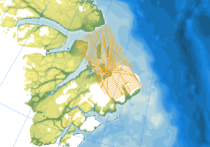
Helicopter-borne Magnetics CASE20
As part of the expedition CASE 20, geological fieldwork and an aeromagnetic survey were conducted in order to study the architecture and structure of the present continental margin of Northeast Greenland. The helicopter-borne magnetic survey in July and August 2018 covered the coastal areas between Independence Fiord and Kronprins Christian Land. During a 2-weeks period nearly 6500 km of aeromagnetic line data were collected covering an area of 17000 km². The distance between the individual lines was 4 km and control profiles were flown every 20-30 km. The aeromagnetic data were recorded by a magnetometer, which was towed approx. 30 m beneath the helicopter.
|
|
Citation proposal
(2023) . Helicopter-borne Magnetics CASE20. https://gdk.gdi-de.org/geonetwork/srv/api/records/3770320b-f532-4837-9381-55d8df3b6a22 |
INSPIRE
Identification
- File identifier
- 3770320b-f532-4837-9381-55d8df3b6a22 XML
- Hierarchy level
- Dataset
Online resource
Resource identifier
- code
- be8cd5a7-c380-40a4-8b8d-928b89ff014a
- Metadata language
- English
Encoding
- Format
- GeoTIFF
- Version
- n/a
- Format
- shp
- Version
- n/a
- Format
- WMS
- Version
- OGC:WMS1.3.0
Projection
Classification of data and services
- Topic category
-
- Geoscientific information
Classification of data and services
Coupled resource
Coupled resource
Classification of data and services
Coupled resource
Coupled resource
Keywords
- GEMET - INSPIRE themes, version 1.0 ( Theme )
-
- Geologie
- Geology
- GEMET - Concepts, version 2.4 ( Theme )
-
- Geophysik
Other keywords
- Keywords ( Theme )
-
- Aerogeophysik
- Aeromagnetik
- Anomalien des erdmagnetischen Feldes
- Airborne geophysics
- helicopter-borne /fixed-wing magnetics
- anomalies of the Earth’s magnetic field
- Keywords ( Place )
-
- Arktis
- Arctic
- Northeast Greenland
- Nordost Grönland
Geographic coverage
N
S
E
W
))
Temporal reference
Temporal extent
Temporal extent
- Date ( Publication )
- 2023-02-22
Quality and validity
- Lineage
- The aeromagnetic data were collected by BGR as part of the CASE program during the CASE 20 expedition in northeast Greenland.
Conformity
Conformity
Conformity
Conformity
Conformity
Conformity
- Explanation
- siehe dazu die angegebene Durchführungsbestimmung
Restrictions on access and use
- Access constraints
- Allgemeine Geschäftsbedingungen, siehe https://www.bgr.bund.de/AGB - General terms and conditions, see https://www.bgr.bund.de/AGB_en. Die bereitgestellten Informationen sind bei Weiterverwendung wie folgt zu zitieren: Datenquelle: AeromagCASE20, (c) BGR, Hannover, 2023
Restrictions on access and use
Responsible organization (s)
Contact for the resource
- Organisation name
- Bundesanstalt für Geowissenschaften und Rohstoffe (BGR)
- polargeologie@bgr.de
Responsible organization (s)
Contact for the resource
- Organisation name
- Bundesanstalt für Geowissenschaften und Rohstoffe (BGR)
- polargeologie@bgr.de
Metadata information
Contact for the metadata
- Organisation name
- Bundesanstalt für Geowissenschaften und Rohstoffe (BGR)
- Date stamp
- 2025-04-07
- Metadata language
- English
- Character set
- UTF8
SDS
Conformance class 1: invocable
Access Point URL
Endpoint URL
Technical specification
Conformance class 2: interoperable
Coordinate reference system
Quality of Service
Access constraints
Limitation
Use constraints
Limitation
Responsible custodian
Contact for the resource
Conformance class 3: harmonized
Overviews
Provided by

Views
3770320b-f532-4837-9381-55d8df3b6a22
Access to the portal
Read here the full details and access to the data.
Associated resources
Not available