 www.geodatenkatalog.de (S3L)
Boden-Klima-Räume (WMS)
Die Boden-Klima-Räume (BKR) stellen Gebiete mit relativ homogenen Standortbedingungen für die landwirtschaftliche Produktion in der Bundesrepublik Deutschland dar. Die Definition der BKR erfolgte auf der Basis von Gemeindegrenzen. Dabei wurden vor allem die Einflüsse von Bodengüte und Klima berücksichtigt.
|
|
Citation proposal
. Boden-Klima-Räume (WMS). https://gdk.gdi-de.org/geonetwork/srv/api/records/389a27de-b330-4e5d-a05d-46258b816985 |
INSPIRE
Identification
- File identifier
- 389a27de-b330-4e5d-a05d-46258b816985 XML
- Hierarchy level
- Service
Online resource
- Protocol
- OGC:WMS-1.3.0-http-get-capabilities
Resource identifier
Encoding
- Format
- PNG
- Version
- unknown
Projection
Classification of data and services
Classification of data and services
- Service Type
- view
- Coupling Type
- Tight
Coupled resource
Coupled resource
Classification of data and services
- Service Type
- view
- Coupling Type
- Tight
Coupled resource
Coupled resource
Keywords
Other keywords
- Keywords ( Theme )
-
- inspireidentifiziert
- opendata
- WMS
- infoMapAccessService
- Boden-Klima-Regionen
- Gebietsgliederung
- Boden
- Klima
- Region
- Gebiet
- Agrarlandschaft
- Landwirtschaft
- Julius Kühn-Institut (JKI)
Geographic coverage
N
S
E
W
))
Temporal reference
Temporal extent
Temporal extent
- Date ( Creation )
- 2013-09-06
Quality and validity
Conformity
Conformity
Conformity
Conformity
Conformity
Conformity
- Explanation
- nicht überprüft
- Explanation
- See the referenced specification
Restrictions on access and use
Restrictions on access and use
- Access constraints
- Nutzungsbedingungen: Dieser Datensatz kann gemäß der "Nutzungsbestimmungen für die Bereitstellung von Geodaten des Bundes" der GeoNutzV vom 19. März 2013 (https://sg.geodatenzentrum.de/web_public/gdz/lizenz/geonutzv.pdf) genutzt werden.
- Access constraints
- {"id": "geoNutz/20130319", "name": "Nutzungsbestimmungen für die Bereitstellung von Geodaten des Bundes", "url": "https://sg.geodatenzentrum.de/web_public/gdz/lizenz/geonutzv.pdf", "quelle": "Quelle: © JKI, Dietmar Roßberg, Volker Michel, Rudolf Graf, Ralf Neukampf (2007)"}
Responsible organization (s)
Contact for the resource
- Organisation name
- Julius Kühn-Institut, Institut für Strategien und Folgenabschätzung
Responsible organization (s)
Contact for the resource
- Organisation name
- Julius Kühn-Institut, Institut für Strategien und Folgenabschätzung
Metadata information
Contact for the metadata
- Organisation name
- Julius Kühn-Institut (JKI)
- Date stamp
- 2025-11-07T13:00:48.97Z
- Metadata language
- German
SDS
Conformance class 1: invocable
- Pass
- false
- Pass
- false
- Pass
- false
Access Point URL
Endpoint URL
Technical specification
- Date
- Explanation
- Der Dienst wurde mit dem EU-Validator geprüft.
- Date
- Explanation
- nicht überprüft
- Date
- Explanation
- See the referenced specification
Conformance class 2: interoperable
Coordinate reference system
Quality of Service
Access constraints
- Access constraints
- Other restrictions
Limitation
Use constraints
Limitation
- string
- Nutzungsbedingungen: Dieser Datensatz kann gemäß der "Nutzungsbestimmungen für die Bereitstellung von Geodaten des Bundes" der GeoNutzV vom 19. März 2013 (https://sg.geodatenzentrum.de/web_public/gdz/lizenz/geonutzv.pdf) genutzt werden.
- string
- {"id": "geoNutz/20130319", "name": "Nutzungsbestimmungen für die Bereitstellung von Geodaten des Bundes", "url": "https://sg.geodatenzentrum.de/web_public/gdz/lizenz/geonutzv.pdf", "quelle": "Quelle: © JKI, Dietmar Roßberg, Volker Michel, Rudolf Graf, Ralf Neukampf (2007)"}
Responsible custodian
Contact for the resource
Conformance class 3: harmonized
Contains Operations
- Operation Name
- GetCapabilities
- Distributed Computing Platforms
- Web services
- Connect Point
- GetCapabilities-Request, Format: XML
Contains Operations
- Operation Name
- GetMap
- Distributed Computing Platforms
- Web services
- Connect Point
- GetMap-Request, Format: PNG
Overviews
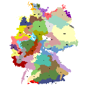
Vorschaubild: Boden-Klima-Räume
Provided by

Views
389a27de-b330-4e5d-a05d-46258b816985
Access to the portal
Read here the full details and access to the data.
Associated resources
Not available