 www.geodatenkatalog.de (S1L)
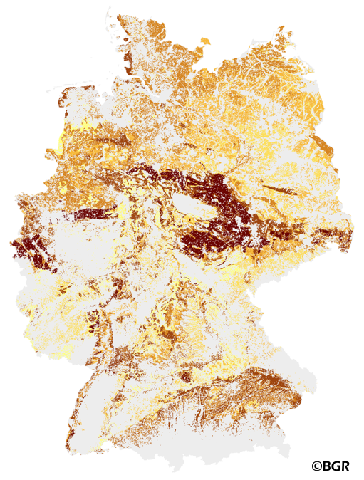
Soil quality rating for cropland in Germany 1:1,000,000
The Muencheberg Soil Quality Rating (SQR) was developed by the Leibniz Centre for Agricultural Landscape Research (ZALF). SQR describes the suitability of sites under agricultural land use and helps to estimate the yield potential of sites at a global scale. This method was especially adapted for application with soil maps by the Federal Institute of Geosciences and Resources BGR and is published in the documentation of Ad-hoc-AG Boden (representing the soil experts of the geological services of the German federal states). The map shows the SQR for cropland in Germany based on the landuse stratified soilmap of Germany at scale 1:1,000,000. Climate (DWD), Relief (BKG) and landuse data (CLC2006) are used as input data in addition to the soil map. SQR consists of a series of pedotransfer rules. First, eight basic soil properties are weighted and combined to describe the soil (substrate, rooting depth, etc.). Next, hazard indicators are derived (drought risk, soil depth above solid rock). These indicators are critical for farming and limit the overall soil quality. Only those hazard indicators were selected for SQR which have the greatest effect on potential grain yield. The final SQR-score ranges from about 0 to 102 points.
|
|
Citation proposal
. Soil quality rating for cropland in Germany 1:1,000,000. https://gdk.gdi-de.org/geonetwork/srv/api/records/3DBC11EE-81E9-41A2-916E-1281DDD6C7A8 |
- Identification
- Distribution
- Quality
- Spatial rep.
- Ref. system
- Content
- Portrayal
- Metadata
- Md. constraints
- Md. maintenance
- Schema info
Identification
Data identification
Citation
- Alternate title
- SQR1000
- Date ( Creation )
- 2013-10-24
- Edition
- Version 1.0
- Identifier
- 47BE6C4F-409A-11E3-8643-8851FB422C62
Author
- Status
- completed Completed
Point of contact
- GEMET - INSPIRE themes, version 1.0 ( Theme )
-
- Boden
- Soil
- GEMET - Concepts, version 2.4 ( Theme )
-
- Ackerbau
- Ackerland
- Bodenart
- Bodenfeuchtigkeit
- Bodenfruchtbarkeit
- Bodengüte
- Bodenkarte
- Bodennutzung
- Bodenstruktur
- Bodenverdichtung
- Bodenversauerung
- Bodenwasserhaushalt
- Ertrag (landwirtschaftlich)
- Getreide
- Humus
- Klima
- Landwirtschaft
- Niederschlag
- SGD-Liste ( Theme )
-
- ackerbauliches Ertragspotential
- Bodeneigenschaften
- Keywords ( Theme )
-
- Bodenwert
- Ertragspotential
- Keywords ( Place )
-
- Bundesrepublik Deutschland
Legal constraints
- Access constraints
- Other restrictions
Legal constraints
- Use constraints
- Other restrictions
- Other constraints
- Allgemeine Geschäftsbedingungen, siehe https://www.bgr.bund.de/AGB - General terms and conditions, see https://www.bgr.bund.de/AGB_en. Die bereitgestellten Informationen sind bei Weiterverwendung wie folgt zu zitieren: Datenquelle: SQR1000 V1.0, (C) BGR, Hannover, 2013.
- Other constraints
- Preis der gedruckten Karte: 11,21 EUR (zzgl. 7% MWSt. und Versandkosten) Weitere Informationen zur Bestellung beim Internationalen Landkartenhaus siehe https://www.bgr.bund.de/produktcenter-bestellhinweis-ILH
- Spatial representation type
- Grid
- Denominator
- 1000000
- Metadata language
- ger German
- Character set
- utf8 UTF8
- Topic category
-
- Geoscientific information
- Farming
N
S
E
W
))
- Geographic identifier
- Regionalschlüssel / 000000000000
Distribution
Distribution
- Distribution format
-
- PDF (n/a )
- georef. TIFF (n/a )
- JPEG (n/a )
- JPEG (n/a )
- PNG (n/a )
- TIFF (n/a )
- gedruckt (n/a )
Digital transfer options
- Transfer size
- 72
- OnLine resource
-
SQR1000 (PDF)
SQR1000 im Format Adobe Acrobat (Auflösung 600 dpi)
Digital transfer options
- Transfer size
- 4
- OnLine resource
-
SQR1000 (georef. TIFF)
SQR1000 im Format georeferenziertes TIFF (Rasterweite 250 m)
Digital transfer options
- Transfer size
- 48
- OnLine resource
-
SQR1000 (JPEG)
SQR1000 im Format JPEG (Auflösung 150 dpi)
Digital transfer options
- Transfer size
- 54
- OnLine resource
-
SQR1000 (JPEG)
SQR1000 im Format JPEG (Auflösung 300 dpi)
Digital transfer options
- Transfer size
- 33
- OnLine resource
-
SQR1000 (PNG)
SQR1000 im Format PNG (Auflösung 150 dpi)
Digital transfer options
- Transfer size
- 53
- OnLine resource
-
SQR1000 (TIFF)
SQR1000 im Format TIFF (Auflösung 300 dpi)
- OnLine resource
-
SQR1000 (gedruckt)
SQR1000 im Format gedruckt, gefalzt
- OnLine resource
-
SQR1000 Internetseite - SQR1000 Website
SQR1000 Internetseite - SQR1000 Website
- OnLine resource
-
Karte im BGR-Geoviewer
Karte im BGR-Geoviewer
Quality
Data quality
Scope
- Hierarchy level
- Dataset
- Statement
- Bodendaten aus BÜK1000N V2.31 (BGR), Klimadaten vom DWD (Referenzperiode 1961-1990), Landnutzung aus Corine Land Cover 2006, Höhendaten vom BKG (DGM250).
Metadata
Metadata
- File identifier
- 3DBC11EE-81E9-41A2-916E-1281DDD6C7A8 XML
- Metadata language
- German
- Character set
- utf8 UTF8
- Hierarchy level
- dataset Dataset
- Hierarchy level name
- Boden
- Date stamp
- 2025-08-11
- Metadata standard name
- INSPIRE Metadata Implementing Rules: Technical Guidelines based on EN ISO 19115 and EN ISO 19119
- Metadata standard version
- n/a
Point of contact
Overviews
Provided by

Views
3DBC11EE-81E9-41A2-916E-1281DDD6C7A8
Access to the portal
Read here the full details and access to the data.
Associated resources
Not available