 My GeoNetwork catalogue
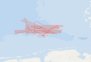
Processed seismic data of Cruise MSM97 GeoHifi 2020
Regarding the use of renewable energy and the reduction of greenhouse-gas emissions, the geological storage of fluids is of particular interest. Therefore, reservoir and barrier formations in the German North Sea come into focus. Due to the widespread distribution of storage and barrier rocks at suitable depths and in combination with a relatively low tectonic overprint, the West Schleswig Block region in the German North Sea shows a high prospectivity for CO2 storage. By means of this high-resolution 2D reflection seismic survey, we want to investigate the potential impairment of geological barriers at the top of geological storage formations (i.e. claystones/mudstones and salt of the Upper Buntsandstein, mudstone dominated formations of the Lower Cretaceous and of the Tertiary). The seismic acquisition setup with a 2400 m active streamer cable with 384 channels will allow a precise image of near-surface structures, such as Quaternary channels, seismic pipe structures, chimneys, polygonal fault systems and crestal faults. In the time period between Nov. 13th and Nov. 24th we acquired 32 lines 2D seismic reflection data (about 1500 km in total) in combination with gravity data, multibeam data and sediment echosounder data. The seismic data resolve the sediments from the seafloor down to the base of the Zechstein. With the acquired data, the sediments of the Mesozoic and Cenozoic up to the seafloor (2-3 seconds of twoway-traveltime) will be imaged in high-resolution for the first time. The imaged fault systems will be investigated regarding their ability to build seal bypass systems. In addition, we acquired seismic data across the Figge Maar blowout crater and we intend to compare these data with the seismic data from the West Schleswig Block.
Simple
- Alternate title
-
MSM97 GeoHifi
- Date (Creation)
- 2023-09-28
- Date (Publication)
- 2023-10-11
- Citation identifier
- d576977c-82d6-4fd5-8517-22cb6c109117
- Citation identifier
- https://doi.org/10.25928/bgr.mssp.msm97
- Status
- Completed
-
GEMET - INSPIRE themes, version 1.0
-
-
Geologie
-
geology
-
-
GEMET - Concepts, version 2.4
-
-
geophysics
-
Geophysik
-
raw material
-
Rohstoff
-
- Theme
-
-
Marine geology
-
Meeresgeologie
-
Seismics
-
Seismik
-
Two-dimensional seismic reflection
-
zweidimensionale Reflektionsseismik
-
GeolDG
-
- Place
-
-
Nordsee
-
North Sea
-
- Access constraints
- Other restrictions
- Other constraints
- Es gelten keine Zugriffsbeschränkungen
- Use constraints
- Other restrictions
- Other constraints
-
Allgemeine Geschäftsbedingungen, siehe http://www.bgr.bund.de/AGB - General terms and conditions, see http://www.bgr.bund.de/AGB_en . Die bereitgestellten Informationen sind bei Weiterverwendung wie folgt zu zitieren: Datenquelle: MSM97 GeoHifi, (c) BGR, Hannover, 2023
- Spatial representation type
- Vector
- Language
- English
- Character set
- UTF8
- Topic category
-
- Geoscientific information
))
- Unique resource identifier
- EPSG:4326
- Distribution format
-
-
Shapefile
(
n/a
)
-
SEG-Y
(
n/a
)
-
P190
(
n/a
)
-
Shapefile
(
n/a
)
- OnLine resource
-
Fahrtlinien (Shapefile)
Fahrtlinien im Format ESRI Shape
- OnLine resource
-
Daten (SEG-Y)
Daten im Format SEG-Y
- OnLine resource
- Fahrtbericht
- OnLine resource
- Navigation (P190)
- OnLine resource
- Karte im BGR-Geoviewer
- Hierarchy level
- Dataset
Conformance result
- Date (Publication)
- 2010-12-08
- Explanation
-
siehe dazu die angegebene Durchführungsbestimmung
- Statement
-
During the period from the 13th November to the 25th November 2020 BGR acquired seismic lines in the North Sea. The survey contain lines BGR20-101 to BGR20-132 and is processed up to prestack time migration. Details are given in the SEG-Y header.
- File identifier
- 3c397954-06d0-497c-9f5d-2dbbfe1ebc95 XML
- Metadata language
- English
- Character set
- UTF8
- Parent identifier
-
Marine Seismic Survey Profiles (MSSP)
06a73c56-06a2-40d8-b806-466222b0760d
- Hierarchy level
- Dataset
- Hierarchy level name
-
Geophysik
- Hierarchy level name
-
GeolDG
- Date stamp
- 2024-03-04
- Metadata standard name
-
INSPIRE Metadata Implementing Rules: Technical Guidelines based on EN ISO 19115 and EN ISO 19119
- Metadata standard version
-
n/a
Overviews
Spatial extent
Provided by
