 www.geodatenkatalog.de (S3L)
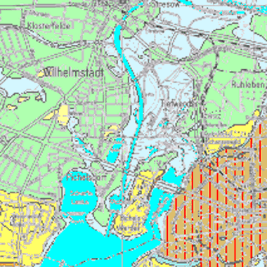
Geologische Karte 1 : 25.000 (Historische GK25, Umweltatlas)
Die Geologische Karte vermittelt im Maßstab 1:25.000 Informationen zur Verbreitung, Beschaffenheit und Abfolge von Gesteinen bis in eine Tiefe von zwei Metern unter der Geländeoberfläche. Sie beruht auf historischen Kartenblättern von 1874 bis 1937.
|
|
Citation proposal
(2017) . Geologische Karte 1 : 25.000 (Historische GK25, Umweltatlas). https://gdk.gdi-de.org/geonetwork/srv/api/records/3cfed238-c727-3aed-af05-1f5af472cb5d |
INSPIRE
Identification
- File identifier
- 3cfed238-c727-3aed-af05-1f5af472cb5d XML
- Hierarchy level
- Dataset
Online resource
Resource identifier
- Metadata language
- German
- Spatial representation type
- Vector
Encoding
- Format
- Text/HTML
- Version
- 4.01
- Specification
- Keine Angabe
Projection
Classification of data and services
- Topic category
-
- Geoscientific information
Classification of data and services
Coupled resource
Coupled resource
Classification of data and services
Coupled resource
Coupled resource
Keywords
- Räumlicher Anwendungsbereich ( Theme )
Other keywords
- Keywords ( Theme )
-
- open data
- opendata
- Karten
- Sachdaten
- Geodaten
- Berlin
- LBGR Brandenburg
- Bergbau
- Rohstoffe
- Umweltatlas
- Geologie
- Gesteine
- Historische Karte
- Urstromtal
- Hochflächen
- Holozän
- Pleistozän
- Quartär
- Tertiär
- Prätertiär
- Sander
- Strauchmoräne
- Schmelzwasser
- Talsande
- Feinsande
- Mittelsande
- Moorablagerung
- Rupelton
Geographic coverage
N
S
E
W
))
Temporal reference
Temporal extent
Temporal extent
- Date ( Creation )
- 1937-12-31
- Date ( Publication )
- 2017-08-28
Quality and validity
- Lineage
- - Historische Kartenblätter der Geologischen Karte 1874-1937 beruhend auf der Auswertung der Schichtenverzeichnisse von Sondierungen und Bohrungen, - Assmann, P. (1961): Geologische Karte von Berlin 1 : 10.000, Blatt 425. - Hrsg.: Der Senator für Bau- und Wohnungswesen; Berlin., - Berendt, G. & Dames, W. (1885): Geologische Übersichtskarte der Umgegend von Berlin 1 : 100.000. - Hrsg.: Preußisch Geol. Landesanstalt; Berlin., - Limberg A. (1995): Stand der geologischen Landesaufnahme in Berlin mit Ergebnissen der zuletzt veröffentlichten Geologischen karten 1 : 10.000, Blatt 425 und 426. - Brandenburgische Geowiss. Beitr., 2, 1, S. 39 - 49, Kleinmachnow., - Wolff, W. (1925): Geologische Übersichtskarte der Umgegend von Berlin 1 : 100.000. - Hrsg.: Preußisch Geologische Landesanstalt; Berlin.
- Denominator
- 25000
Conformity
Conformity
Conformity
Conformity
Conformity
Conformity
Restrictions on access and use
- Access constraints
- Für die Nutzung der Daten ist die Datenlizenz Deutschland - Zero - Version 2.0 anzuwenden. Die Lizenz ist über https://www.govdata.de/dl-de/zero-2-0 abrufbar.
- Access constraints
- {"id":"dl-zero-de/2.0","name":"Datenlizenz Deutschland - Zero - Version 2.0","url":"https://www.govdata.de/dl-de/zero-2-0"}
Restrictions on access and use
Responsible organization (s)
Contact for the resource
- Organisation name
- Senatsverwaltung für Mobilität, Verkehr, Klimaschutz und Umwelt Berlin
- Organisation name
- Senatsverwaltung für Mobilität, Verkehr, Klimaschutz und Umwelt Berlin
Responsible organization (s)
Contact for the resource
- Organisation name
- Senatsverwaltung für Mobilität, Verkehr, Klimaschutz und Umwelt Berlin
- Organisation name
- Senatsverwaltung für Mobilität, Verkehr, Klimaschutz und Umwelt Berlin
Metadata information
Contact for the metadata
- Organisation name
- Senatsverwaltung für Stadtentwicklung, Bauen und Wohnen Berlin
- Date stamp
- 2025-11-19T00:00:00Z
- Metadata language
- German
- Character set
- UTF8
SDS
Conformance class 1: invocable
Access Point URL
Endpoint URL
Technical specification
Conformance class 2: interoperable
Coordinate reference system
Quality of Service
Access constraints
Limitation
Use constraints
Limitation
Responsible custodian
Contact for the resource
Conformance class 3: harmonized
Overviews
Vorschaubild
Provided by

Views
3cfed238-c727-3aed-af05-1f5af472cb5d
Access to the portal
Read here the full details and access to the data.
Associated resources
Not available