 www.geodatenkatalog.de (S1L)
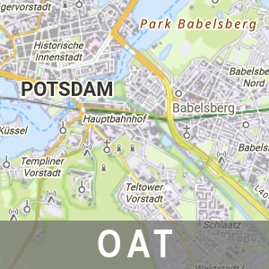
OAT basemap.de - Ausprägung Brandenburg mit Berlin
Der Kartendienst „basemap.de“ (https://basemap.de/) ist ein von Bund und Ländern gemeinsam entwickelter Internet-Kartendienst. Die Datengrundlagen sind vor allem das ATKIS Basis-DLM aus den Bundesländern sowie die am Bundesamt für Kartographie und Geodäsie (BKG) gepflegten Digitalen Landschaftsmodelle (DLM) in den Maßstäben 1 : 250 000 und 1 : 1 000 000. Die Ausprägung Brandenburg mit Berlin ist dabei eine brandenburgische Variante von basemap.de, welche zusätzlich mit brandenburgischen Daten (insbesondere aus ALKIS, der Georeferenzierten Adresse) und brandenburgspezifischen Inhalten, wie z.B. den sorbischen Bezeichnungen und den Orts- und Landschaftsnamen angereichert wird. Damit bietet die LGB gegenüber den deutschlandweiten basemap-Produkten weiterhin, wie bisher, topographische Kartendienste in hoher Datenaktualität an.
|
|
Citation proposal
. OAT basemap.de - Ausprägung Brandenburg mit Berlin. https://gdk.gdi-de.org/geonetwork/srv/api/records/3e0df578-9182-4bb2-9e70-e4151ad9045d |
INSPIRE
Identification
- File identifier
- 3e0df578-9182-4bb2-9e70-e4151ad9045d XML
- Hierarchy level
- service Service
Online resource
Resource identifier
Encoding
Projection
Classification of data and services
Classification of data and services
- Service Type
- download
- Coupling Type
- tight Tight
Coupled resource
Coupled resource
Classification of data and services
- Service Type
- download
- Coupling Type
- tight Tight
Coupled resource
Coupled resource
Keywords
Other keywords
- Keywords
-
- opendata
- Keywords ( Theme )
-
- Tatsächliche Nutzung
- AAA
- LGB
- Vermessung
- OGC API - Tiles
- AdV
- Geobasisdaten
- GDI
- OAT
- AdVMIS
- Keywords ( Place )
-
- Brandenburg
- BB
Geographic coverage
N
S
E
W
))
Temporal reference
Temporal extent
Temporal extent
- Date ( Creation )
- 2024-09-11T00:00:00
Quality and validity
Conformity
Conformity
Conformity
Conformity
Conformity
Conformity
Restrictions on access and use
Restrictions on access and use
- Access constraints
- Die Daten können gemäß der „Datenlizenz Deutschland - Namensnennung - Version 2.0“ (https://www.govdata.de/dl-de/by-2-0) genutzt werden. Namensnennung: "GeoBasis-DE/LGB", Beispiel: „© GeoBasis-DE/LGB, dl-de/by-2-0, (Daten geändert)“, (Klammer = optional)
- Access constraints
- {"id":"dl-by-de/2.0","name":"Datenlizenz Deutschland - Namensnennung - Version 2.0","url":"https://www.govdata.de/dl-de/by-2-0","quelle":"Quelle: © GeoBasis-DE/LGB, dl-de/by-2-0"}
Responsible organization (s)
Contact for the resource
- Organisation name
- Landesvermessung und Geobasisinformation Brandenburg (LGB)
Responsible organization (s)
Contact for the resource
- Organisation name
- Landesvermessung und Geobasisinformation Brandenburg (LGB)
Metadata information
Contact for the metadata
- Organisation name
- Landesvermessung und Geobasisinformation Brandenburg (LGB)
- Date stamp
- 2025-07-18T14:52:59
- Metadata language
- ger German
SDS
Conformance class 1: invocable
Access Point URL
Endpoint URL
Technical specification
Conformance class 2: interoperable
Coordinate reference system
Quality of Service
Access constraints
- Access constraints
- Other restrictions
Limitation
Use constraints
Limitation
- string
- Die Daten können gemäß der „Datenlizenz Deutschland - Namensnennung - Version 2.0“ (https://www.govdata.de/dl-de/by-2-0) genutzt werden. Namensnennung: "GeoBasis-DE/LGB", Beispiel: „© GeoBasis-DE/LGB, dl-de/by-2-0, (Daten geändert)“, (Klammer = optional)
- string
- {"id":"dl-by-de/2.0","name":"Datenlizenz Deutschland - Namensnennung - Version 2.0","url":"https://www.govdata.de/dl-de/by-2-0","quelle":"Quelle: © GeoBasis-DE/LGB, dl-de/by-2-0"}
Responsible custodian
Contact for the resource
Conformance class 3: harmonized
Contains Operations
- Operation Name
- LandingPage
- Distributed Computing Platforms
- Web services
- Connect Point
- https://ogc-api.geobasis-bb.de/basemap-bebb
Overviews
OAT-basemap.de BE/BB
Provided by

Views
3e0df578-9182-4bb2-9e70-e4151ad9045d
Access to the portal
Read here the full details and access to the data.
Associated resources
Not available