 www.geodatenkatalog.de (S3L)
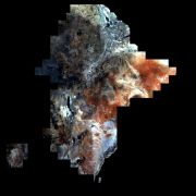
SoilSuite - Sentinel-2 - Africa, 4 year composite (2018-2021)
The SoilSuite contains a collection of different image data products that provide information about the spectral and statistical properties of soils and other bare surfaces of three East-African countries (Rwanda, Kenya and Ethiopia). It is created using DLR's Soil Composite Mapping Processor (ScMAP), which utilises the Sentinel-2 data archive. SCMaP is a specialised processing chain for detecting and analysing bare soils/surfaces on a large (continental) scale. Bare surface and soil pixels are selected using a combined NDVI and NBR index (PVIR2) that optimises the exclusion of photosynthetically active and non-active vegetation. The index is calculated and applied for each individual pixel. All SoilSuite products are calculated based on the available Sentinel-2 scenes recorded between January 2018 and December 2021 in the target region. The data package excludes all scenes with a cloud cover of larger than 80 percent and a sun elevation of less than 20 degrees. The spectral composite products are calculated from the mean value after extensive removal of clouds, haze and snow effects at both scene and pixel level. The spectral data products are available at a pixel size of 20 m and contain 10 Sentinel-2 bands (B02, B03, B04, B05, B06, B07, B08, B08a, B11, B12). The SoilSuite comprises: (a) “Bare Surface Reflectance Composite – Mean” that provides the spectral properties of soils that vary due to different soil organic carbon (SOC) content, soil moisture and soil minerology. This product is often used for spectral and digital soil mapping approaches, (b) “Bare Surface Reflectance Composite - Standard deviation” informing about the spectral dynamic of bare surfaces and soils, (c) “Bare Surface Reflectance Composite – 95% Confidence” contains information about the reliability of the spectral information due to the number of valid observations per pixel, (d) “Bare Surface Statistics Product” provides the number of bare soil occurrences over the total number of valid observations (Band 1), the number of bare soil occurrences (Band 2) and the total number of valid observations (Band 3), (e) “Mask” is a product that aggregates simple landcover classes that occur during the time period between 2018 - 2021 (Sentinel-2). The three-class Mask contains bare surface occurrences (1), permanent vegetation (2) and other surfaces such as water bodies, urban areas, roads (3). Additionally, the SoilSuite provides (f) “Reflectance Composite – Mean” that represents the mean reflectance of all valid Sentinel-2 observations between 2018 – 2021 including vegetation, bare and other surfaces, and (g) “Reflectance Composite – Standard deviation”, which contains the standard deviation per band for all valid Sentinel-2 observations between 2018 – 2021.
The SoilSuite Africa was produced as part of the Earth Observation-based derivation of soil information funded by the project 'Land, Soil and Crop Information Services (LSC-IS) to support Climate-Smart Agriculture (DeSIRA)'. LSC-IS is funded by the European Union through its DeSIRA program and the Netherlands' Ministry of Foreign Affairs, with a contribution from ISRIC - World Soil Information.
|
|
Citation proposal
German Aerospace Center (DLR). SoilSuite - Sentinel-2 - Africa, 4 year composite (2018-2021). https://gdk.gdi-de.org/geonetwork/srv/api/records/40f2db67-d180-431f-b275-2b975c552d36 |
INSPIRE
Identification
- File identifier
- 40f2db67-d180-431f-b275-2b975c552d36 XML
- Hierarchy level
- Dataset
Online resource
- Protocol
- WWW:LINK-1.0-http--link
- Protocol
- WWW:LINK-1.0-http--link
- Protocol
- WWW:LINK-1.0-http--link
- Protocol
- WWW:LINK-1.0-http--link
- Protocol
- WWW:LINK-1.0-http--link
- Protocol
- OGC:WMS-http-get-capabilities
- Protocol
- WWW:LINK-1.0-http--link
- Protocol
- WWW:LINK-1.0-http--link
- Protocol
- OGC:WMS
- Protocol
- OGC:WMS
- Protocol
- OGC:WMS
- Protocol
- OGC:WMS
- Protocol
- OGC:WMS
- Protocol
- OGC:WMS
- Protocol
- OGC:WMS
- Protocol
- OGC:WMS
- Protocol
- OGC:WMS
Resource identifier
- Metadata language
- eng
- Spatial representation type
- Grid
Encoding
Projection
- code
- WGS 84 / World Mercator (EPSG:3395)
Classification of data and services
- Topic category
-
- Geoscientific information
Classification of data and services
Coupled resource
Coupled resource
Classification of data and services
Coupled resource
Coupled resource
Keywords
- GEMET - INSPIRE themes, version 1.0 ( Theme )
-
- Soil
- Spatial scope ( Place )
Other keywords
- Keywords
-
- DLR
- EOC
- Land
- SCMaP
- Soil
- Sentinel-2
- East-Africa
- Temporal Composites
- Soil Coverage
- Soil Composite Mapping Processor
- Reflectance Composite
- Surface Reflectance Composite
- Bare Soil Coverage
- Bare Soil Frequency
- opendata
Geographic coverage
))
Temporal reference
Temporal extent
Temporal extent
- Date ( Creation )
- 2025-04-15T00:00:00
Quality and validity
- Lineage
- As input data, all Sentinel-2 images from March 2018 to December 2022 over larger Europe in L1C data format are used. All scenes with a cloud cover of larger than 80 % and a sun elevation of lower than 20° were excluded.
- Denominator
- 40000
Conformity
Conformity
Conformity
Conformity
Conformity
Conformity
- Explanation
- See the referenced specification.
Restrictions on access and use
- Access constraints
- License
- Access constraints
- Nutzungsbedingungen: License, https://creativecommons.org/licenses/by/4.0/
- Access constraints
-
{"id": "cc-by/4.0",
"name": "Creative Commons Namensnennung – 4.0 International (CC BY 4.0)",
"url": "http://dcat-ap.de/def/licenses/cc-by/4.0",
"quelle": "Copyright DLR (year of production)"}
Restrictions on access and use
Responsible organization (s)
Contact for the resource
- Organisation name
- German Aerospace Center (DLR)
- paul.karlshoefer@dlr.de
- Organisation name
- German Aerospace Center (DLR)
- geoservice@dlr.de
Responsible organization (s)
Contact for the resource
- Organisation name
- German Aerospace Center (DLR)
- paul.karlshoefer@dlr.de
- Organisation name
- German Aerospace Center (DLR)
- geoservice@dlr.de
Metadata information
Contact for the metadata
- Organisation name
- German Aerospace Center (DLR)
- geoservice@dlr.de
- Date stamp
- 2025-10-16T09:07:24
- Metadata language
- English
- Character set
- UTF8
SDS
Conformance class 1: invocable
Access Point URL
Endpoint URL
Technical specification
Conformance class 2: interoperable
Coordinate reference system
Quality of Service
Access constraints
Limitation
Use constraints
Limitation
Responsible custodian
Contact for the resource
Conformance class 3: harmonized
Overviews

Provided by
