 www.geodatenkatalog.de (S3F)
Topographische Karte 1 : 50 000 - Ausgabe Volkswirtschaft (1974-1982) 1108-2 Bad Liebenwerda
Die als Ausgabe Volkswirtschaft (AV) bezeichneten Topographischen Kartenwerke hatten vorrangig die Zweckbestimmung als Kartengrundlage für die Bereiche Verwaltung, Wissenschaft und Kultur, Ordnung und Sicherheit, Industrie und Landwirtschaft, Verkehr, Planung und Umweltschutz der ehemaligen DDR zu dienen. Sie trugen den Geheimhaltungsgrad -Vertrauliche Dienstsache- bzw. -Nur für den Dienstgebrauch-. Inhaltsebenen der TK50AV sind: Grundriß/Gitternetz-Schwarz, Gewässer-Blau, Relief/Straßenfüllung/Bebauungsflächen-Rotbraun, Waldflächen-Grün.
|
|
Citation proposal
. Topographische Karte 1 : 50 000 - Ausgabe Volkswirtschaft (1974-1982) 1108-2 Bad Liebenwerda. Landesvermessung und Geobasisinformation Brandenburg (LGB) https://gdk.gdi-de.org/geonetwork/srv/api/records/420a577c-d4cb-4179-bf94-12965a9d8b9a |
INSPIRE
Identification
- File identifier
- 420a577c-d4cb-4179-bf94-12965a9d8b9a XML
- Hierarchy level
- dataset Dataset
Online resource
Resource identifier
- Metadata language
- ger German
Encoding
Projection
Classification of data and services
- Topic category
-
- Imagery base maps earth cover
Classification of data and services
Coupled resource
Coupled resource
Classification of data and services
Coupled resource
Coupled resource
Keywords
- BE/BB Schlagwortliste, Version 1.0 ( Theme )
-
- Vermessung
Other keywords
- Keywords
-
- opendata
- Keywords ( Theme )
-
- 1:50.000
- Karte
- bodenbedeckung
- Historisch
Geographic coverage
N
S
E
W
))
Temporal reference
Temporal extent
Temporal extent
- Date ( Revision )
- 1979-01-01T00:00:00
- Date ( Creation )
- 1979-01-01T00:00:00
Quality and validity
- Lineage
- Eine Auskunft über die Herkunft der Daten erhalten Sie per Anfrage an die E-Mail kundenservice@geobasis-bb.de.
- Denominator
- 50000
Conformity
Conformity
Conformity
Conformity
Conformity
Conformity
Restrictions on access and use
- Access constraints
- Die Daten können gemäß der „Datenlizenz Deutschland - Namensnennung - Version 2.0“ (https://www.govdata.de/dl-de/by-2-0) genutzt werden. Namensnennung: "GeoBasis-DE/LGB", Beispiel: „© GeoBasis-DE/LGB, dl-de/by-2-0, (Daten geändert)“, (Klammer = optional)
- Access constraints
- {"id":"dl-by-de/2.0","name":"Datenlizenz Deutschland - Namensnennung - Version 2.0","url":"https://www.govdata.de/dl-de/by-2-0","quelle":"Quelle: © GeoBasis-DE/LGB, dl-de/by-2-0"}
Restrictions on access and use
Responsible organization (s)
Contact for the resource
- Organisation name
- Landesvermessung und Geobasisinformation Brandenburg (LGB)
Responsible organization (s)
Contact for the resource
- Organisation name
- Landesvermessung und Geobasisinformation Brandenburg (LGB)
Metadata information
Contact for the metadata
- Organisation name
- Landesvermessung und Geobasisinformation Brandenburg (LGB)
- Date stamp
- 2021-11-09T09:46:29
- Metadata language
- ger German
- Character set
- utf8 UTF8
SDS
Conformance class 1: invocable
Access Point URL
Endpoint URL
Technical specification
Conformance class 2: interoperable
Coordinate reference system
Quality of Service
Access constraints
Limitation
Use constraints
Limitation
Responsible custodian
Contact for the resource
Conformance class 3: harmonized
Overviews
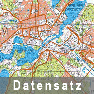
Beispielausschnitt aus der Topographischen Karte 1 : 50 000 - Ausgabe Volkswirtschaft
Provided by

Views
420a577c-d4cb-4179-bf94-12965a9d8b9a
Access to the portal
Read here the full details and access to the data.
Associated resources
Not available