 www.geodatenkatalog.de (S2L)
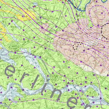
Grundwassergleichen 2015 (Umweltatlas)
Grundwassergleichenkarte des Hauptgrundwasserleiters und des Panketalgrundwasserleiters für den Mai 2015
|
|
Citation proposal
. Grundwassergleichen 2015 (Umweltatlas). https://gdk.gdi-de.org/geonetwork/srv/api/records/42642878-e2a7-36ea-b599-1003f8cdbd01 |
- Identification
- Distribution
- Quality
- Spatial rep.
- Ref. system
- Content
- Portrayal
- Metadata
- Md. constraints
- Md. maintenance
- Schema info
Identification
Data identification
Citation
- Date ( Creation )
- 2015-12-15
- Presentation form
- Digital map
- Status
- Completed
Point of contact
- Keywords ( Theme )
-
- opendata
- open data
- Karten
- Geodaten
- Berlin
- Grundwasserstände
- Grundwasserstand
- Grundwasserganglinien
- Grundwasserhöhenlinien
- Spatial scope
Legal constraints
- Access constraints
- Other restrictions
Legal constraints
- Use constraints
- Other restrictions
- Other constraints
- Für die Nutzung der Daten ist die Datenlizenz Deutschland - Namensnennung - Version 2.0 anzuwenden. Die Lizenz ist über https://www.govdata.de/dl-de/by-2-0 abrufbar. Der Quellenvermerk gemäß (2) der Lizenz lautet "Geoportal Berlin / [Titel des Datensatzes]".
- Other constraints
- { "id": "dl-by-de/2.0" , "name": " Datenlizenz Deutschland - Namensnennung - Version 2.0 ", "url": "https://www.govdata.de/dl-de/by-2-0", "quelle": "Geoportal Berlin / [Titel des Datensatzes]" }
- Spatial representation type
- Vector
- Spatial representation type
- Text, table
- Denominator
- 50000
- Metadata language
- German
- Character set
- UTF8
- Topic category
-
- Geoscientific information
Extent
N
S
E
W
))
Geographic description
- Extent type code
- true
- Geographic identifier
- 110000000000
Quality
Data quality
- Hierarchy level
- Dataset
Conformance result
Citation
- Date ( Publication )
- 2010-12-08
- Explanation
- see referenced specification
- Pass
- false
Conformance result
Citation
- Date ( Publication )
- 2013-12-10
- Explanation
- see referenced specification
- Pass
- false
- Statement
- 1712 Grundwassermesswerte und 31 Oberflächenwassermesswerte aus den Messnetzen des Landesgrundwasserdienstes Berlin, der Berliner Wasserbetriebe, der Wasserwerke in Brandenburg und des Landesamts für Umwelt, Gesundheit und Verbraucherschutz Brandenburg vom Mai 2015
Ref. system
- Reference system identifier
- http://www.opengis.net/def/crs/EPSG/0/25833
Metadata
Metadata
- File identifier
- 42642878-e2a7-36ea-b599-1003f8cdbd01 XML
- Metadata language
- German
- Character set
- UTF8
- Hierarchy level
- Dataset
- Date stamp
- 2024-01-04T09:57:53
- Metadata standard name
- ISO 19115/19119 – BE
- Metadata standard version
- 1.0.0
Overviews
Provided by

Views
42642878-e2a7-36ea-b599-1003f8cdbd01
Access to the portal
Read here the full details and access to the data.
Associated resources
Not available