 www.geodatenkatalog.de (S3L)
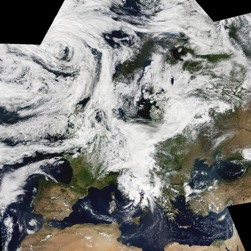
MODIS - Image Mosaic - Europe
The Moderate Resolution Imaging Spectroradiometer (MODIS) is a key instrument aboard the Terra (EOS AM-1) and Aqua (EOS PM-1) satellites. The MODIS-EU image mosaic is a seamless true color composite of all Terra and Acqua passes received at DLR during a single day. Daily and Near Real Time (NRT) products are available. For the composite, MODIS channels 1, 4, 3 are used. The channels are re-projected, radiometrically enhanced, and seamlessly stitched to obtain a visually appealing result.
Terra passes from north to south across the equator in the morning, while Aqua passes the equator south to north in the afternoon. Both MODIS instruments are viewing the entire Earth surface every 1 to 2 days, acquiring data in 36 spectral bands.
|
|
Citation proposal
German Aerospace Center (DLR). MODIS - Image Mosaic - Europe. https://gdk.gdi-de.org/geonetwork/srv/api/records/43487af3-1fd7-4b5b-8e50-db02a61479b9 |
INSPIRE
Identification
- File identifier
- 43487af3-1fd7-4b5b-8e50-db02a61479b9 XML
- Hierarchy level
- Series
Online resource
- Protocol
- WWW:LINK-1.0-http--link
- Protocol
- OGC:WMS
- Protocol
- OGC:WMS
- Protocol
- OGC:WCS
- Protocol
- WWW:LINK-1.0-http--link
Resource identifier
- Metadata language
- eng
- Spatial representation type
- Grid
Encoding
Projection
Classification of data and services
- Topic category
-
- Climatology, meteorology, atmosphere
Classification of data and services
Coupled resource
Coupled resource
Classification of data and services
Coupled resource
Coupled resource
Keywords
- GEMET - INSPIRE themes, version 1.0 ( Theme )
-
- Orthoimagery
Other keywords
- Keywords
-
- MODIS-EU
- MODIS
- Moderate Resolution Imaging Spectroradiometer
- Aqua
- Terra
- true color composite
- visible wavelengths
- Europe
Geographic coverage
))
Temporal reference
Temporal extent
Temporal extent
- Date ( Creation )
- 2015-02-24T00:00:00
Quality and validity
- Lineage
-
For details see:
https://www.dlr.de/de/eoc/forschung-transfer/themen/aktuelle-wetterbilder/modis-eu
- Denominator
- 500000
Conformity
Conformity
Conformity
Conformity
Conformity
Conformity
- Explanation
- See the referenced specification
Restrictions on access and use
- Access constraints
- Nutzungsbedingungen: Copyright
Restrictions on access and use
Responsible organization (s)
Contact for the resource
- Organisation name
- German Aerospace Center (DLR)
- Helpdesk-DFD@dlr.de
- Organisation name
- German Aerospace Center (DLR)
- geoservice@dlr.de
Responsible organization (s)
Contact for the resource
- Organisation name
- German Aerospace Center (DLR)
- Helpdesk-DFD@dlr.de
- Organisation name
- German Aerospace Center (DLR)
- geoservice@dlr.de
Metadata information
Contact for the metadata
- Organisation name
- German Aerospace Center (DLR)
- geoservice@dlr.de
- Date stamp
- 2024-09-27T14:05:10
- Metadata language
- English
- Character set
- UTF8
SDS
Conformance class 1: invocable
Access Point URL
Endpoint URL
Technical specification
Conformance class 2: interoperable
Coordinate reference system
Quality of Service
Access constraints
Limitation
Use constraints
Limitation
Responsible custodian
Contact for the resource
Conformance class 3: harmonized
Overviews

Provided by
