 www.geodatenkatalog.de (S1L)
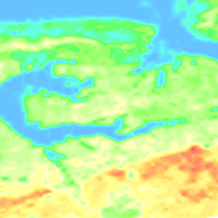
Helicopter-borne Radiometrics (HRD) Area 109 Hadelner Marsch
BGR conducted an airborne survey in the region of the Hadelner Marsch in cooperation with the GGA Institute (now LIAG) as well as with the water suppliers of Land Hadeln and Wingst. The survey area Hadelner Marsch (2004) is bounded by the river Elbe to the north and by the settlements Bederkesa and Lamstedt to the south. The size of the area is about 700 km². The area was surveyed with 20 flights totalling to 2970 line-km (75,822 survey points). The nominal separation of the 117 ESE-WNW lines and 13 NNE-SSW tie lines was 250 m and 2000 m, respectively. The maps display the total count, the (equivalent) content of potassium, uranium and thorium as well as the exposure rate at ground.
|
|
Citation proposal
. Helicopter-borne Radiometrics (HRD) Area 109 Hadelner Marsch. https://gdk.gdi-de.org/geonetwork/srv/api/records/4587f894-5d6b-4df3-bb8f-2e3a46b318fb |
INSPIRE
Identification
- File identifier
- 4587f894-5d6b-4df3-bb8f-2e3a46b318fb XML
- Hierarchy level
- Dataset
Online resource
Resource identifier
- code
- ff0681b8-01a0-47b2-aaf6-b33ac45bcbe9
- Metadata language
- German
- Spatial representation type
- Grid
Encoding
- Format
- georef. TIFF
- Version
- n/a
- Format
- Version
- n/a
Projection
Classification of data and services
- Topic category
-
- Geoscientific information
Classification of data and services
Coupled resource
Coupled resource
Classification of data and services
Coupled resource
Coupled resource
Keywords
- GEMET - INSPIRE themes, version 1.0 ( Theme )
-
- Geologie
- Geology
- GEMET - Concepts, version 2.4 ( Theme )
-
- Geophysik
Other keywords
- Keywords ( Theme )
-
- Aerogeophysik
- Hubschrauber-Radiometrie
- Äquivalentgehalte
- Thorium
- Uran
- Kalium
- Ionendosisleistung
- airborne geophysics
- helicopter-borne radiometrics
- equivalent concentrations
- uranium
- potassium
- exposure rate
- Keywords ( Place )
-
- Niedersachsen
Geographic coverage
N
S
E
W
))
Temporal reference
Temporal extent
Temporal extent
- Date ( Revision )
- 2019-03-01
Quality and validity
- Lineage
- Erarbeitung im Rahmen des BGR-Projektes "D-AERO-Auswertung"
Conformity
Conformity
Conformity
Conformity
Conformity
Conformity
- Explanation
- siehe dazu die angegebene Durchführungsbestimmung
Restrictions on access and use
- Access constraints
- Allgemeine Geschäftsbedingungen, siehe https://www.bgr.bund.de/AGB - General terms and conditions, see https://www.bgr.bund.de/AGB_en. Die bereitgestellten Informationen sind bei Weiterverwendung wie folgt zu zitieren: Datenquelle: 109HadelnerMarschHRD, (c) BGR, Hannover, 2019, doi:10.25928/dsa5-w551
Restrictions on access and use
Responsible organization (s)
Contact for the resource
- Organisation name
- Bundesanstalt für Geowissenschaften und Rohstoffe (BGR)
- heli@bgr.de
Responsible organization (s)
Contact for the resource
- Organisation name
- Bundesanstalt für Geowissenschaften und Rohstoffe (BGR)
- heli@bgr.de
Metadata information
Contact for the metadata
- Organisation name
- Bundesanstalt für Geowissenschaften und Rohstoffe (BGR)
- Date stamp
- 2025-04-07
- Metadata language
- German
- Character set
- UTF8
SDS
Conformance class 1: invocable
Access Point URL
Endpoint URL
Technical specification
Conformance class 2: interoperable
Coordinate reference system
Quality of Service
Access constraints
Limitation
Use constraints
Limitation
Responsible custodian
Contact for the resource
Conformance class 3: harmonized
Overviews
Provided by

Views
4587f894-5d6b-4df3-bb8f-2e3a46b318fb
Access to the portal
Read here the full details and access to the data.
Associated resources
Not available