 www.geodatenkatalog.de (S1L)
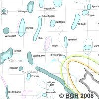
Salt Structures of Northern Gemany (1:500,000)
New map of salt structures in northern Germany at a scale of 1:500,000.
|
|
Citation proposal
(2008) . Salt Structures of Northern Gemany (1:500,000). https://gdk.gdi-de.org/geonetwork/srv/api/records/46464EDB-CB37-46E1-B6A4-9410FA725CCE |
Simple
- Alternate title
- BGR-Salzkarte
- Date ( Publication )
- 2008-04-01
- Edition
- 1. Auflage
- Identifier
- F91FA242-2A0C-408E-9CC6-8DEF05F65F63
Author
Author
Author
- Other citation details
- Größe der gedruckte Karte: 185,0 cm x 85,0 cm; doppelseitig bedruckt - Size of the printed map: 185.0 cm x 85.0 cm; printed double-sided
- Status
- completed Completed
Point of contact
- GEMET - INSPIRE themes, version 1.0 ( Theme )
-
- Geologie
- Geology
- Keywords ( Theme )
-
- Diapir
- Jura
- Keuper
- Norddeutschland
- Perm
- Salinar
- Salzintrusion
- Salzkissen
- Salzstock
- Salzstruktur
- Keywords ( Place )
-
- Deutschland
- Access constraints
- Other restrictions
- Use constraints
- Other restrictions
- Other constraints
- Allgemeine Geschäftsbedingungen, s. https://www.bgr.bund.de/agb - General Terms and Conditions, s. https://www.bgr.bund.de/agb_en
- Other constraints
- Preis der gedruckten Karte: 14,02 EUR (zzgl. 7% MWSt. und Versandkosten) Weitere Informationen zur Bestellung beim Internationalen Landkartenhaus siehe https://www.bgr.bund.de/produktcenter-bestellhinweis-ILH
- Spatial representation type
- Grid
- Denominator
- 500000
- Metadata language
- ger German
- Character set
- utf8 UTF8
- Topic category
-
- Geoscientific information
N
S
E
W
))
- Distribution format
-
- PDF 300 dpi (n/a )
- PDF 150 dpi (n/a )
- JPEG 150 dpi (n/a )
- PNG 300 dpi (n/a )
- PNG 75 dpi (n/a )
- gedruckt (n/a )
- Transfer size
- 16
- OnLine resource
-
BGR-Salzkarte (PDF)
BGR-Salzkarte im Format Adobe Acrobat (Auflösung >300 dpi)
- Transfer size
- 16
- OnLine resource
-
BGR-Salzkarte (PDF)
BGR-Salzkarte im Format Adobe Acrobat (Auflösung 150 dpi)
- Transfer size
- 17
- OnLine resource
-
BGR-Salzkarte (JPEG)
BGR-Salzkarte im Format JPEG (Auflösung 150 dpi)
- Transfer size
- 23
- OnLine resource
-
BGR-Salzkarte (PNG)
BGR-Salzkarte im Format PNG (Auflösung 300 dpi)
- Transfer size
- 6
- OnLine resource
-
BGR-Salzkarte (PNG)
BGR-Salzkarte im Format PNG (Auflösung 75 dpi)
- OnLine resource
-
BGR-Salzkarte (gedruckt)
BGR-Salzkarte im Format gedruckt, gefalzt
- OnLine resource
-
Vorschau - Preview
Vorschau - Preview
- Hierarchy level
- Dataset
- Statement
- Baldschuhn R., Frisch, U. & Kockel, F. [Hrsg.] (1996): Geotektonischer Atlas von NW-Deutschland. Reinhardt, H.-G. (1989): Tiefenlinien der Horizonte T9 / X1 / X2 - Regionales reflexionsseismisches Kartenwerk, VEB Geophysik Leipzig (unveröff.). -
gmd:MD_Metadata
- File identifier
- 46464EDB-CB37-46E1-B6A4-9410FA725CCE XML
- Metadata language
- German
- Character set
- utf8 UTF8
- Hierarchy level
- dataset Dataset
- Hierarchy level name
- Geologie
- Date stamp
- 2025-08-14
- Metadata standard name
- INSPIRE Metadata Implementing Rules: Technical Guidelines based on EN ISO 19115 and EN ISO 19119
- Metadata standard version
- n/a
Point of contact
Overviews
Provided by

Views
46464EDB-CB37-46E1-B6A4-9410FA725CCE
Access to the portal
Read here the full details and access to the data.
Associated resources
Not available