 www.geodatenkatalog.de (S1L)
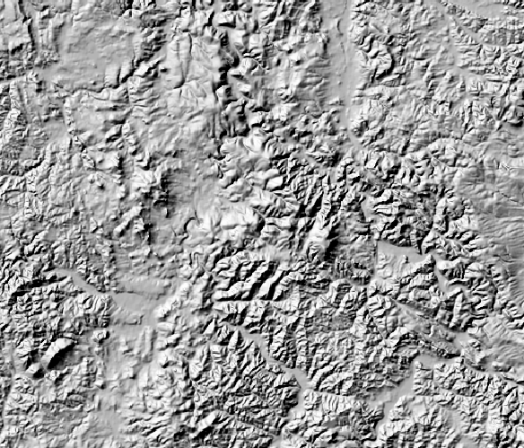
WMS Digitales Geländemodell Gitterweite 200 m
Darstellungsdienst des Digitales Geländemodell Gitterweite 200 m für das Gebiet der Bundesrepublik Deutschland.
Zur einheitlichen Beschreibung des Reliefs des Gebietes der Bundesrepublik Deutschland werden im Rahmen des ATKIS®-Projektes durch die deutsche Landesvermessung Digitale Geländemodelle (DGM) unterschiedlicher Qualitätsstufen aufgebaut.
Das Digitale Geländemodell DGM200 beschreibt die Geländeformen der Erdoberfläche durch eine in einem regelmäßigen Gitter angeordnete, in Lage und Höhe georeferenzierte Punktmenge. Die Gitterweite beträgt 200 m.
Für die Visualisierung des Reliefs stellt der Darstellungsdienst folgende Layer bereit: Höheninformation, Colormap, Relief, Schummerung Bodenauflösung: 200m
|
|
Citation proposal
. WMS Digitales Geländemodell Gitterweite 200 m. Bundesamt für Kartographie und Geodäsie (BKG) https://gdk.gdi-de.org/geonetwork/srv/api/records/47CE2030-3588-47A6-93ED-A1A17857D8B4 |
Simple
Identification info
- Alternate title
- Digitale Geländemodelle
- Alternate title
- wms_dgm200
- Date ( Creation )
- 2012-07-01T00:00:00.000+02:00
- Status
- On going
Point of contact
Publisher
- GEMET - Concepts, version 3.1 ( Theme )
- Keywords
-
- DGM200
- INSPIRE:ViewService
- WMS
- ViewService
- infoMapAccessService
- BKG
- Bundesamt für Kartographie und Geodäsie
- Deutschland
- Schummerung
- Colormap
- DGM
- Digitale Geländemodelle
- Service Classification, version 1.0 ( Theme )
-
- infoMapAccessService
- Keywords
-
- AdVMIS
- Access constraints
- otherRestrictions Other restrictions
- Use constraints
- otherRestrictions Other restrictions
- Other constraints
- Die Daten sind urheberrechtlich geschützt. Die Daten werden geldleistungsfrei gemäß der Datenlizenz Deutschland Namensnennung 2.0 (https://www.govdata.de/dl-de/by-2-0) zur Verfügung gestellt. Die Verwendung des Datensatzes für die Pflege und Erweiterung der Daten des OpenStreetMap Projektes wird unter Einhaltung der im Ergänzungstext beschriebenen Angaben zur Namensnennung ausdrücklich erlaubt, siehe https://sgx.geodatenzentrum.de/web_public/gdz/lizenz/deu/datenlizenz_deutschland_ergaenzungstext_namensnennung.pdf. Der Quellenvermerk ist zu beachten.
- Other constraints
- Quellenvermerk: © GeoBasis-DE / BKG (Jahr)
- Service Type
- view
- Service Version
- OGC:WMS 1.3.0
- Extent type code
- true
- Geographic identifier
- Raumbezug des Datensatzes
))
Coupled Resource
- Operation Name
- GetCapabilities
Coupled Resource
- Operation Name
- GetMap
Coupled Resource
- Operation Name
- GetFeatureInfo
- Coupling Type
- Tight
Contains Operations
- Operation Name
- GetCapabilities
- Distributed Computing Platforms
- HTTPGet
- Invocation Name
- GetCapabilities
Parameter
- Name
- REQUEST=GetCapabilities
- Description
- Request name
- Optionality
- 0
- Repeatability
- false
- Name
Parameter
- Name
- UPDATESEQUENCE=number
- Description
- Sequence number for cache control
- Optionality
- 1
- Repeatability
- false
- Name
Parameter
- Name
- VERSION=1.3.0
- Description
- Request version
- Optionality
- 1
- Repeatability
- false
- Name
Parameter
- Name
- SERVICE=WMS
- Description
- Service type
- Optionality
- 0
- Repeatability
- false
- Name
- Connect Point
- https://sg.geodatenzentrum.de/wms_dgm200?
Contains Operations
- Operation Name
- GetMap
- Distributed Computing Platforms
- HTTPGet
- Invocation Name
- GetMap
Parameter
- Name
- SLD=styled_layer_descriptor_URL
- Description
- URL of Styled Layer Descriptor (as defined in SLD Specification)
- Optionality
- 1
- Repeatability
- false
- Name
Parameter
- Name
- Other sample dimension(s)
- Description
- Value of other dimensions as appropriate
- Optionality
- 1
- Repeatability
- false
- Name
Parameter
- Name
- WFS=web_feature_service_URL
- Description
- URL of Web Feature Service providing features to be symbolized using SLD
- Optionality
- 1
- Repeatability
- false
- Name
Parameter
- Name
- EXCEPTIONS=exception_format
- Description
- The format in which exceptions are to be reported by the WMS (default=SE_XML)
- Optionality
- 1
- Repeatability
- false
- Name
Parameter
- Name
- VERSION=1.3.0
- Description
- Request version
- Optionality
- 0
- Repeatability
- false
- Name
Parameter
- Name
- SRS=namespace:identifier
- Description
- Spatial Reference System
- Optionality
- 0
- Repeatability
- false
- Name
Parameter
- Name
- WIDTH=output_width
- Description
- Width in pixels of map picture
- Optionality
- 0
- Repeatability
- false
- Name
Parameter
- Name
- BBOX=minx,miny,maxx,maxy
- Description
- Bounding box corners (lower left, upper right) in SRS units
- Optionality
- 0
- Repeatability
- false
- Name
Parameter
- Name
- TRANSPARENT=TRUE|FALSE
- Description
- Background transparency of map (default=FALSE)
- Optionality
- 1
- Repeatability
- false
- Name
Parameter
- Name
- STYLES=style_list
- Description
- Comma-separated list of one rendering style per requested layer. Optional if SLD parameter is present
- Optionality
- 0
- Repeatability
- false
- Name
Parameter
- Name
- ELEVATION=elevation
- Description
- Elevation of layer desired
- Optionality
- 1
- Repeatability
- false
- Name
Parameter
- Name
- TIME=time
- Description
- Time value of layer desired
- Optionality
- 1
- Repeatability
- false
- Name
Parameter
- Name
- FORMAT=output_format
- Description
- Output format of map
- Optionality
- 0
- Repeatability
- false
- Name
Parameter
- Name
- BGCOLOR=color_value
- Description
- Hexadecimal red-green-blue color value for the background color (default=0xFFFFFF)
- Optionality
- 1
- Repeatability
- false
- Name
Parameter
- Name
- Vendor-specific parameters
- Description
- Optional experimental parameters
- Optionality
- 1
- Repeatability
- false
- Name
Parameter
- Name
- LAYERS=layer_list
- Description
- Comma-separated list of one or more map layers. Optional if SLD parameter is present
- Optionality
- 0
- Repeatability
- false
- Name
Parameter
- Name
- HEIGHT=output_height
- Description
- Height in pixels of map picture
- Optionality
- 0
- Repeatability
- false
- Name
Parameter
- Name
- REQUEST=GetMap
- Description
- Request name
- Optionality
- 0
- Repeatability
- false
- Name
- Connect Point
- https://sg.geodatenzentrum.de/wms_dgm200?
Contains Operations
- Operation Name
- GetFeatureInfo
- Distributed Computing Platforms
- HTTPGet
- Invocation Name
- GetFeatureInfo
Parameter
- Name
- X=pixel_column
- Description
- X coordinate in pixels of feature (measured from upper left corner=0)
- Optionality
- 0
- Repeatability
- false
- Name
Parameter
- Name
- (map_request_copy)
- Description
- Partial copy of the Map request parameters that generated the map for which information is desired
- Optionality
- 0
- Repeatability
- false
- Name
Parameter
- Name
- VERSION=1.3.0
- Description
- Request version
- Optionality
- 0
- Repeatability
- false
- Name
Parameter
- Name
- INFO_FORMAT=output_format
- Description
- Return format of feature information (MIME type)
- Optionality
- 1
- Repeatability
- false
- Name
Parameter
- Name
- Y=pixel_row
- Description
- Y coordinate in pixels of feature (measured from upper left corner=0)
- Optionality
- 0
- Repeatability
- false
- Name
Parameter
- Name
- FEATURE_COUNT=number
- Description
- Number of features about which to return information (default=1)
- Optionality
- 1
- Repeatability
- false
- Name
Parameter
- Name
- EXCEPTIONS=exception_format
- Description
- The format in which exceptions are to be reported by the WMS (default=application/vnd.ogc.se_xml)
- Optionality
- 1
- Repeatability
- false
- Name
Parameter
- Name
- Vendor-specific parameters
- Description
- Optional experimental parameters
- Optionality
- 1
- Repeatability
- false
- Name
Parameter
- Name
- REQUEST=GetFeatureInfo
- Description
- Request name
- Optionality
- 0
- Repeatability
- false
- Name
Parameter
- Name
- QUERY_LAYERS=layer_list
- Description
- Comma-separated list of one or more layers to be queried
- Optionality
- 0
- Repeatability
- false
- Name
- Connect Point
- https://sg.geodatenzentrum.de/wms_dgm200?
- Operates On
- Reference system identifier
- CRS 84: CRS 84 / mathematisch
- Distribution format
-
- TIFF ()
- PNG ()
- JPEG ()
- Hierarchy level
- Service
- Other
- 3
Conformance result
- Date ( Publication )
- 2006-03-15
- Explanation
- see the referenced specification
- Pass
- true
Conformance result
- Date ( Publication )
- 2013-04-04
- Explanation
- see the referenced specification
- Pass
- true
gmd:MD_Metadata
- File identifier
- 47CE2030-3588-47A6-93ED-A1A17857D8B4 XML
- Metadata language
- German
- Character set
- UTF8
- Hierarchy level
- service Service
- Hierarchy level name
- service
- Date stamp
- 2025-06-03
- Metadata standard name
- ISO19115/ISO19119
- Metadata standard version
- Erste Edition 2003-05-01/2005:PDAM 1
Point of contact
Overviews
Provided by
