 www.geodatenkatalog.de (S1L)
Processed seismic data of Cruise ME67 1984
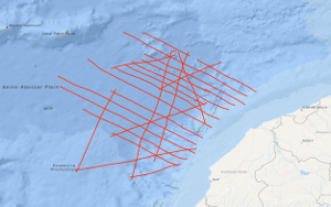
The area of the 1st leg of METEOR cruise no. 67 lies off the Moroccan coast between longitudes 32.5°N and 35°N and latitude 12°W. Within this continental margin segment multichannel reflection seismic measurements were carried out in parallel with magnetic and gravimetric measurements on 22 lines with a total length of 4,378 km during the period from January 20th to February 13th 1984, with the research objectives: i) to collect new geophysical data for a better understanding of magmatic-volcanic and tectonic processes during the initial drifting phase, and ii) to search for suitable positions for deep drilling sites of the "Ocean Drilling Programme" in the transition zone between continental and oceanic crust. A distinct and sharp reflection seismic boundary running from about 31°30'N/11°W in the south to 34°30'N/10°25'W in the north separates flat-lying Mesozoic sediments overlying slightly structured basement of the Jurassic "Magnetic Quiet Zone" from the complex Moroccan piercement zone in the east. A prominent magnetic anomaly, called S1, is nearly coincident with the sharp reflection seismic boundary, and is thought to represent most probably the initial drifting zone. The Moroccan piercement zone is interpreted to represent the eastern part of a pre-Jurassic rift-basin which conjugated western part lies off Nova Scotia/Canada. Subsidence associated with small-scale rotational block-faulting was time-transgressive in the Moroccan piercement zone, e.g. it started in Triassic time in the central part of the rift-basin and affected successively its landward parts apparently due to successively cooling of the stretched and thinned crust. Weak magnetic anomalies trending approximately NE-SW were recorded within the Jurassic "Magnetic Quiet Zone" lying west of magnetic anomaly S1. These anomalies can be correlated over distances of up to 300 km. They are interpreted to represent either variations of the geomagnetic field intensity or field reversals during a time of weak geomagnetic field.
|
|
Citation proposal
. Processed seismic data of Cruise ME67 1984. https://gdk.gdi-de.org/geonetwork/srv/api/records/4b8e6d83-717b-48f6-af22-f53be1a4467b |
- Identification
- Distribution
- Quality
- Spatial rep.
- Ref. system
- Content
- Portrayal
- Metadata
- Md. constraints
- Md. maintenance
- Schema info
Identification
Data identification
Citation
- Alternate title
- ME67 1984
- Date ( Creation )
- 1984-02-13
- Identifier
- 9d5bf07d-2435-3b83-7308-6f39b398e35c
- Status
- completed Completed
Point of contact
- GEMET - INSPIRE themes, version 1.0 ( Theme )
-
- Geologie
- geology
- GEMET - Concepts, version 2.4 ( Theme )
-
- geophysics
- Geophysik
- raw material
- Rohstoff
- Keywords ( Theme )
-
- Marine geology
- Meeresgeologie
- Seismics
- Seismik
- Two-dimensional seismic reflection
- zweidimensionale Reflektionsseismik
- Keywords ( Place )
-
- Seine Abyssal Plain
- Seine-Tiefseeebene
- Central East Atlantic
- Zentraler Ostatlantik
Legal constraints
- Access constraints
- Other restrictions
Legal constraints
- Use constraints
- Other restrictions
- Other constraints
- Allgemeine Geschäftsbedingungen, siehe http://www.bgr.bund.de/AGB - General terms and conditions, see http://www.bgr.bund.de/AGB_en. Die bereitgestellten Informationen sind bei Weiterverwendung wie folgt zu zitieren: Datenquelle: ME67 1984, (c) BGR, Hannover, 1984
- Spatial representation type
- Vector
- Metadata language
- English
- Character set
- UTF8
- Topic category
-
- Geoscientific information
N
S
E
W
))
Distribution
Distribution
- Distribution format
-
- Shapefile (n/a )
Digital transfer options
- Transfer size
- 2
- OnLine resource
-
ME67 1984 (Shapefile)
ME67 1984 im Format ESRI Shape
- OnLine resource
-
Profile ME67-01
Profile ME67-01
- OnLine resource
-
Profile ME67-02
Profile ME67-02
- OnLine resource
-
Profile ME67-03
Profile ME67-03
- OnLine resource
-
Profile ME67-04
Profile ME67-04
- OnLine resource
-
Profile ME67-06
Profile ME67-06
- OnLine resource
-
Profile ME67-07
Profile ME67-07
- OnLine resource
-
Profile ME67-09
Profile ME67-09
- OnLine resource
-
Profile ME67-10A
Profile ME67-10A
- OnLine resource
-
Profile ME67-10B
Profile ME67-10B
- OnLine resource
-
Profile ME67-11
Profile ME67-11
- OnLine resource
-
Profile ME67-12
Profile ME67-12
- OnLine resource
-
Profile ME67-13
Profile ME67-13
- OnLine resource
-
Profile ME67-14
Profile ME67-14
- OnLine resource
-
Profile ME67-15
Profile ME67-15
- OnLine resource
-
Profile ME67-16
Profile ME67-16
- OnLine resource
-
Profile ME67-17
Profile ME67-17
- OnLine resource
-
Profile ME67-18
Profile ME67-18
- OnLine resource
-
Profile ME67-19A
Profile ME67-19A
- OnLine resource
-
Profile ME67-19B
Profile ME67-19B
- OnLine resource
-
Profile ME67-20
Profile ME67-20
- OnLine resource
-
Profile ME67-21
Profile ME67-21
- OnLine resource
-
Profile ME67-22A
Profile ME67-22A
- OnLine resource
-
Profile ME67-22B
Profile ME67-22B
- OnLine resource
-
Profile ME67-24
Profile ME67-24
- OnLine resource
-
Karte im BGR-Geoviewer
Karte im BGR-Geoviewer
Quality
Data quality
Scope
- Hierarchy level
- Dataset
Conformance result
Citation
- Date ( Publication )
- 2010-12-08
- Explanation
- siehe dazu die angegebene Durchführungsbestimmung
- Statement
- During the period from the 20th January to the 13th February 1984 BGR acquired seismic lines off Central Morocco. Lines ME67-05 and ME67-09B are raw data. Lines ME67-01, ME67-02, ME67-03, ME67-04, ME67-06, ME67-07, ME67-09, ME67-10A, ME67-10B and ME67-11 to ME67-024 are processed (migrated) data.
Metadata
Metadata
- File identifier
- 4b8e6d83-717b-48f6-af22-f53be1a4467b XML
- Metadata language
- English
- Character set
- UTF8
- Parent identifier
- 06a73c56-06a2-40d8-b806-466222b0760d
- Hierarchy level
- Dataset
- Hierarchy level name
- Geophysik
- Date stamp
- 2023-11-14
- Metadata standard name
- INSPIRE Metadata Implementing Rules: Technical Guidelines based on EN ISO 19115 and EN ISO 19119
- Metadata standard version
- n/a
Point of contact
Overviews
Provided by

Views
4b8e6d83-717b-48f6-af22-f53be1a4467b
Access to the portal
Read here the full details and access to the data.
Associated resources
Not available