 www.geodatenkatalog.de (S1F)
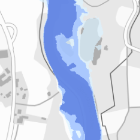
Hochwassergefahrenflächen HQhäufig
Die Hochwassergefahrenflächen HQhäufig zeigen, welche Gebiete bei einem häufigen Hochwasser betroffen sind.
|
|
Citation proposal
. Hochwassergefahrenflächen HQhäufig. https://gdk.gdi-de.org/geonetwork/srv/api/records/4c1845f1-88e8-4157-88b4-187faadcd809 |
INSPIRE
Identification
- File identifier
- 4c1845f1-88e8-4157-88b4-187faadcd809 XML
- Hierarchy level
- dataset Dataset
Online resource
Resource identifier
- Metadata language
- ger German
- Spatial representation type
- vector Vector
Encoding
- Format
- sonstiges
- Version
- keine Angabe
Projection
Classification of data and services
- Topic category
-
- Inland waters
- Environment
Classification of data and services
Coupled resource
Coupled resource
Classification of data and services
Coupled resource
Coupled resource
Keywords
- Spatial scope
-
- Regional
Other keywords
- Keywords ( Theme )
-
- Hochwasser
- Hochwassergefahren
- Hochwassergefahrenflächen
- Überschwemmungsgebiet
- HQhäufig
- Keywords
-
- gdiby
Geographic coverage
N
S
E
W
))
Temporal reference
Temporal extent
Temporal extent
- Date ( Creation )
- 2013-09-10
Quality and validity
- Lineage
- Die Hochwassergefahrenflächen HQhäufig werden im Rahmen des Projektes „Hochwassergefahren- und Hochwasserrisikokarten“ mithilfe von Strömungsmodellen (hydraulische 1D- und 2D-Modelle) ermittelt.
Conformity
Conformity
Conformity
Conformity
Conformity
Conformity
Restrictions on access and use
- Use limitation
- keine Einschränkungen
- Access constraints
- Der Datensatz/Dienst steht unter der Lizenz: Creative Commons Namensnennung - Weitergabe unter gleichen Bedingungen 4.0 International (CC BY-SA 4.0). Die Namensnennung des Bayerischen Landesamtes für Umwelt als Rechteinhaber hat in folgender Weise zu erfolgen: "Datenquelle: Bayerisches Landesamt für Umwelt, www.lfu.bayern.de". Die Nutzung von Daten über Dienste ist geldleistungsfrei. Bei Bezug von Daten über die Datenstelle des LfU (nur Daten, die nicht über Dienste verfügbar sind) wird eine Bereitstellungsgebühr erhoben, die sich an der Umweltgebührenordnung orientiert.
- Access constraints
- { "id": "cc-by-sa", "name": "Creative Commons Namensnennung - Weitergabe unter gleichen Bedingungen (CC BY-SA)", "quelle": "Datenquelle: Bayerisches Landesamt für Umwelt, www.lfu.bayern.de", "url": "http://creativecommons.org/licenses/by-sa/3.0/deed.de" }
Restrictions on access and use
Responsible organization (s)
Contact for the resource
- Organisation name
- Bayerisches Landesamt für Umwelt
Responsible organization (s)
Contact for the resource
- Organisation name
- Bayerisches Landesamt für Umwelt
Metadata information
Contact for the metadata
- Organisation name
- Bayerisches Landesamt für Umwelt
- Date stamp
- 2022-10-26T06:57:28+01:00
- Metadata language
- ger German
- Character set
- utf8 UTF8
SDS
Conformance class 1: invocable
Access Point URL
Endpoint URL
Technical specification
Conformance class 2: interoperable
Coordinate reference system
Quality of Service
Access constraints
Limitation
Use constraints
Limitation
Responsible custodian
Contact for the resource
Conformance class 3: harmonized
Overviews
Provided by

Views
4c1845f1-88e8-4157-88b4-187faadcd809
Access to the portal
Read here the full details and access to the data.
Associated resources
Not available