 www.geodatenkatalog.de (S1L)
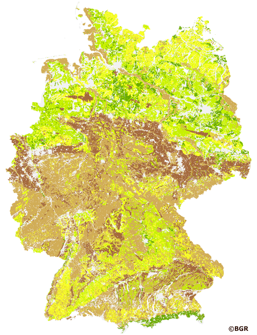
Soil erodibility on soils in Germany
The K-factor of the Universal soil loss equation (USLE) describes the erodibility of soils. Basically the factor depends on six soil properties: the content of silt and very fine sand, the content of sand, the organic matter content, the permeability of the soil, the aggregation of the top soil and the stone content. The method has been adapted for the DIN 19708:2005-02. The first two factors are summarized. The K-factor can now be described by the soil texture class. The DIN method is published in the documentation of AG Boden (representing the soil experts of the geological surveys of the German federal states). For the application with soil maps, the method was adapted by the Federal Institute for Geosciences and Natural Resources (BGR). The presented K-factor is based on the soil texture class, the organic content, the gravel content, the permeability of the soil and the aggregation of the top soil. The map shows the K-factor for soils in Germany based on the landuse stratified soil map of Germany at scale 1:1,000.000.
|
|
Citation proposal
(2021) . Soil erodibility on soils in Germany. https://gdk.gdi-de.org/geonetwork/srv/api/records/4c4cfec0-2108-4821-8a55-9dbda180d876 |
INSPIRE
Identification
- File identifier
- 4c4cfec0-2108-4821-8a55-9dbda180d876 XML
- Hierarchy level
- Dataset
Online resource
Resource identifier
- code
- 3b538570-be07-11eb-b219-10e7c63313a0
- Metadata language
- German
Encoding
- Format
- georef. TIFF
- Version
- n/a
Projection
Classification of data and services
- Topic category
-
- Geoscientific information
Classification of data and services
Coupled resource
Coupled resource
Classification of data and services
Coupled resource
Coupled resource
Keywords
- GEMET - INSPIRE themes, version 1.0 ( Theme )
-
- Soil
- Boden
- GEMET - Concepts ( Theme )
-
- Bodenkarte
- Ackerbau
- Bodenart
- Boden
- Bodendegradation
- Bodenerosion
- Bodenschutz
- Bodenzustand
- Erosion
- Erosionsschutz
- SGD-Liste ( Theme )
-
- Wassererosion
- Freies Schlagwort ( Theme )
-
- K-Faktor
- ABAG
- USLE
- Erodibilität
- Erosionsanfälligkeit
- Erosionsgefährdung
- Erodierbarkeit
Other keywords
- Keywords ( Place )
-
- Deutschland
Geographic coverage
N
S
E
W
))
Temporal reference
Temporal extent
Temporal extent
- Date ( Creation )
- 2021-05-26
- Date ( Publication )
- 2021-06-10
Quality and validity
- Lineage
- Nutzungsdifferenzierte Bodenübersichtskarte der Bundesrepublik Deutschland 1:1.000.000 (BÜK1000N), Version 2.32.
Conformity
Conformity
Conformity
Conformity
Conformity
Conformity
- Explanation
- siehe dazu die angegebene Durchführungsbestimmung
Restrictions on access and use
- Access constraints
- Allgemeine Geschäftsbedingungen, siehe http://www.bgr.bund.de/AGB - General terms and conditions, see http://www.bgr.bund.de/AGB_en. Die bereitgestellten Informationen sind bei Weiterverwendung wie folgt zu zitieren: Datenquelle: KFaktor1000_250 V1.1, (C) BGR, Hannover, 2021
Restrictions on access and use
Responsible organization (s)
Contact for the resource
- Organisation name
- Bundesanstalt für Geowissenschaften und Rohstoffe (BGR)
- fis.bo@bgr.de
Responsible organization (s)
Contact for the resource
- Organisation name
- Bundesanstalt für Geowissenschaften und Rohstoffe (BGR)
- fis.bo@bgr.de
Metadata information
Contact for the metadata
- Organisation name
- Bundesanstalt für Geowissenschaften und Rohstoffe (BGR)
- Date stamp
- 2025-04-07
- Metadata language
- German
- Character set
- UTF8
SDS
Conformance class 1: invocable
Access Point URL
Endpoint URL
Technical specification
Conformance class 2: interoperable
Coordinate reference system
Quality of Service
Access constraints
Limitation
Use constraints
Limitation
Responsible custodian
Contact for the resource
Conformance class 3: harmonized
Overviews
Provided by

Views
4c4cfec0-2108-4821-8a55-9dbda180d876
Access to the portal
Read here the full details and access to the data.
Associated resources
Not available