 www.geodatenkatalog.de (S3L)
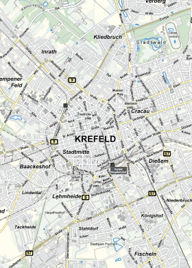
Stadtkarte Krefeld
Die Stadtkarte Krefeld zeigt das gesamte Stadtgebiet Krefeld. Sie dient der Orientierung oder als Grundlage für thematische Karten. Der amtliche Stadtplan enthält das Verkehrsnetz, die Bebauung und die Bodennutzung.
Die Stadtkarte wird in verschiedenen Maßstäben aufbereitet (1:20.000 und 1:50.000) sowie in unterschiedlicher Farbgestaltung (grau, light, farbig). Je nach Kartenmaßstab werden die Daten stärker generalisiert. Auch die Auswahl der Beschriftungen in der Karte unterscheidet sich je Maßstab.
|
|
Citation proposal
(2024) . Stadtkarte Krefeld. https://gdk.gdi-de.org/geonetwork/srv/api/records/4c65e9b0-9aeb-4fb7-a6a6-494319ad57eb |
- Identification
- Distribution
- Quality
- Spatial rep.
- Ref. system
- Content
- Portrayal
- Metadata
- Md. constraints
- Md. maintenance
- Schema info
Identification
Data identification
Citation
- Date ( Publication )
- 2024-10-15T00:00:00.000+02:00
- Status
- On going
Point of contact
Maintenance information
- Maintenance and update frequency
- As needed
- Update scope
- Dataset
- Keywords
-
- Stadt Krefeld
- Stadtkarte
- Hintergrundkarte
- Übersichtskarte
- Stadtplan
- opendata
- Keywords ( Theme )
-
- REGI
- UMTHES Thesaurus ( Theme )
- GEMET - Concepts, version 3.1 ( Theme )
Legal constraints
- Use constraints
- Other restrictions
- Other constraints
- Datenlizenz Deutschland - Zero - Version 2.0 [https://www.govdata.de/dl-de/zero-2-0]
- Other constraints
- {"id":"dl-zero-de/2.0","name":"Datenlizenz Deutschland – Zero – Version 2.0","url":"https://www.govdata.de/dl-de/zero-2-0","quelle":""}
Legal constraints
- Access constraints
- otherRestrictions Other restrictions
- Metadata language
- German
- Topic category
-
- Society
- Boundaries
- Location
Extent
Bounding Polygon
- Extent type code
- true
Geographic description
- Extent type code
- true
- Geographic identifier
- Krefeld, Gemeinde (051140000000)
N
S
E
W
))
Distribution
Distribution
- Distribution format
-
- ()
- OnLine resource
- Stadtkarten - Stadt Krefeld
- OnLine resource
- WMS Stadtkarte Krefeld
- OnLine resource
- WMS Stadtkarte Krefeld
Quality
Data quality
- Hierarchy level
- Dataset
- Statement
- Amtliche Basiskarte
Metadata
Metadata
- File identifier
- 4c65e9b0-9aeb-4fb7-a6a6-494319ad57eb XML
- Metadata language
- German
- Character set
- UTF8
- Hierarchy level
- dataset Dataset
- Date stamp
- 2025-07-22
- Metadata standard name
- ISO19115
- Metadata standard version
- 2003/Cor.1:2006
Point of contact
Overviews
Provided by

Views
4c65e9b0-9aeb-4fb7-a6a6-494319ad57eb
Access to the portal
Read here the full details and access to the data.
Associated resources
Not available