 www.geodatenkatalog.de (S3L)
Überschwemmungsgebiete und Hochwassergefahren - WMS
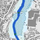
Die Hochwassergefahrenflächen zeigen, welche Flächen bei Hochwasserereignissen unterschiedlicher Eintrittswahrscheinlichkeit betroffen sind. Dadurch kann verglichen werden, welche Flächen jeweils bei einem häufigen (HQhäufig), 100-jährlichen (HQ100) und extremen Hochwasser (HQextrem) unter Wasser stehen.
Die Überschwemmungsgebiete werden auf der Grundlage der Hochwassergefahrenflächen für ein HQ100 durch amtliche Bekanntmachung vorläufig gesichert und anschließend in einem formellen Verfahren per Rechtsverordnung festgesetzt (§ 76 Wasserhaushaltsgesetz). In Überschwemmungsgebieten gelten Nutzungseinschränkungen. Maximale Bildgröße: 4096 x 4096 Pixel.
|
|
Citation proposal
(2013) . Überschwemmungsgebiete und Hochwassergefahren - WMS. https://gdk.gdi-de.org/geonetwork/srv/api/records/4cab2c12-fa7e-49c3-97ba-f4f33af3a598 |
- Identification
- Distribution
- Quality
- Spatial rep.
- Ref. system
- Content
- Portrayal
- Metadata
- Md. constraints
- Md. maintenance
- Schema info
Identification
Identification info
Service Identification (19119)
Citation
- Alternate title
- Wasser
- Date ( Publication )
- 2013-09-11T00:00:00.000+02:00
- Status
- On going
Point of contact
- Website
- https://www.lfu.bayern.de
Maintenance information
- Maintenance and update frequency
- Weekly
- Update scope
- Service
- Service Classification, version 1.0 ( Theme )
-
- infoMapAccessService
- Keywords
-
- gdiby
- vorläufig gesicherte Gebiete zur HW-Entlastung/-Rückhaltung
- Flutpolder
- Hochwasser
- Überschwemmungsgebiet
- festgesetztes Überschwemmungsgebiet
- vorläufig gesichertes Überschwemmungsgebiet
- Hochwassergefahren
- Hochwassergefahrenflächen
- Brückenstatus
- geschützte Gebiete
- Berechnungsgrenzen
- hochwassergeschützt
- überschwemmungsgefährdet
- Bayern
- HQhäufig
- HQ10
- HQ5
- HQ100
- HQmittel
- HQextrem
- HQselten
- Hochwasserrisiko
- Use limitation
- keine Einschränkungen
Legal constraints
- Use constraints
- Other restrictions
- Other constraints
- Creative Commons Namensnennung - Weitergabe unter gleichen Bedingungen 4.0 International (CC BY-SA 4.0); Datenquelle: Bayerisches Landesamt für Umwelt, www.lfu.bayern.de
- Other constraints
- {"id":"cc-by-sa/4.0","name":"Creative Commons Namensnennung - Weitergabe unter gleichen Bedingungen 4.0 International (CC BY-SA 4.0)","url":"https://creativecommons.org/licenses/by-sa/4.0/deed.de","quelle":"Bayerisches Landesamt für Umwelt, www.lfu.bayern.de"}
Legal constraints
- Access constraints
- otherRestrictions Other restrictions
- Service Type
- view
- Service Version
- OGC:WMS 1.3.0
Extent
- Description
- Der Dienst umfasst die Landesfläche Bayerns.
N
S
E
W
))
Coupled Resource
- Operation Name
- GetCapabilities
Coupled Resource
- Operation Name
- GetMap
Coupled Resource
- Operation Name
- GetFeatureInfo
Coupled Resource
- Operation Name
- esri_wms:GetStyles
Coupled Resource
- Operation Name
- GetCapabilities
Coupled Resource
- Operation Name
- GetMap
Coupled Resource
- Operation Name
- GetFeatureInfo
Coupled Resource
- Operation Name
- esri_wms:GetStyles
Coupled Resource
- Operation Name
- GetCapabilities
Coupled Resource
- Operation Name
- GetMap
Coupled Resource
- Operation Name
- GetFeatureInfo
Coupled Resource
- Operation Name
- esri_wms:GetStyles
Coupled Resource
- Operation Name
- GetCapabilities
Coupled Resource
- Operation Name
- GetMap
Coupled Resource
- Operation Name
- GetFeatureInfo
Coupled Resource
- Operation Name
- esri_wms:GetStyles
Coupled Resource
- Operation Name
- GetCapabilities
Coupled Resource
- Operation Name
- GetMap
Coupled Resource
- Operation Name
- GetFeatureInfo
Coupled Resource
- Operation Name
- esri_wms:GetStyles
Coupled Resource
- Operation Name
- GetCapabilities
Coupled Resource
- Operation Name
- GetMap
Coupled Resource
- Operation Name
- GetFeatureInfo
Coupled Resource
- Operation Name
- esri_wms:GetStyles
Coupled Resource
- Operation Name
- GetCapabilities
Coupled Resource
- Operation Name
- GetMap
Coupled Resource
- Operation Name
- GetFeatureInfo
Coupled Resource
- Operation Name
- esri_wms:GetStyles
Coupled Resource
- Operation Name
- GetCapabilities
Coupled Resource
- Operation Name
- GetMap
Coupled Resource
- Operation Name
- GetFeatureInfo
Coupled Resource
- Operation Name
- esri_wms:GetStyles
Coupled Resource
- Operation Name
- GetCapabilities
Coupled Resource
- Operation Name
- GetMap
Coupled Resource
- Operation Name
- GetFeatureInfo
Coupled Resource
- Operation Name
- esri_wms:GetStyles
Coupled Resource
- Operation Name
- GetCapabilities
Coupled Resource
- Operation Name
- GetMap
Coupled Resource
- Operation Name
- GetFeatureInfo
Coupled Resource
- Operation Name
- esri_wms:GetStyles
Coupled Resource
- Operation Name
- GetCapabilities
Coupled Resource
- Operation Name
- GetMap
Coupled Resource
- Operation Name
- GetFeatureInfo
Coupled Resource
- Operation Name
- esri_wms:GetStyles
- Coupling Type
- Tight
Contains Operations
- Operation Name
- GetCapabilities
- Distributed Computing Platforms
- Web services
- Operation Description
- application/vnd.ogc.wms_xml; text/xml;
Contains Operations
- Operation Name
- GetMap
- Distributed Computing Platforms
- Web services
- Operation Description
- image/bmp; image/jpeg; image/tiff; image/png; image/png8; image/png24; image/png32; image/gif; image/svg+xml;
Contains Operations
- Operation Name
- GetFeatureInfo
- Distributed Computing Platforms
- Web services
- Operation Description
- application/vnd.esri.wms_raw_xml; application/vnd.esri.wms_featureinfo_xml; application/vnd.ogc.wms_xml; text/xml; text/html; text/plain;
Contains Operations
- Operation Name
- esri_wms:GetStyles
- Distributed Computing Platforms
- Web services
- Operation Description
- application/vnd.ogc.sld+xml;
- Operates On
-
- Brückenstatus HQ100
- Brückenstatus HQhäufig
- Berechnungsgrenzen
- Hochwassergefahrenflächen HQ100
- Vorläufig gesicherte Gebiete zur HW-Entlastung/-Rückhaltung
- Hochwassergeschützte Gebiete HQ100
- Festgesetzte Überschwemmungsgebiete
- Hochwassergefahrenflächen HQextrem
- Vorläufig gesicherte Überschwemmungsgebiete
- Hochwassergefahrenflächen HQhäufig
- Brückenstatus HQextrem
Distribution
Distribution
- Distribution format
-
- Sonstiges ()
Distributor
Distributor
- Website
- https://www.lfu.bayern.de
- Fees
- geldleistungsfrei
- OnLine resource
-
URL des Dienstes
URL des Dienstes
- OnLine resource
-
Dienst "Überschwemmungsgebiete und Hochwassergefahren - WMS" (GetCapabilities)
application/vnd.ogc.wms_xml; text/xml;
Metadata
Metadata
- File identifier
- 4cab2c12-fa7e-49c3-97ba-f4f33af3a598 XML
- Metadata language
- German
- Character set
- UTF8
- Hierarchy level
- service Service
- Hierarchy level name
- service
- Date stamp
- 2025-08-13
- Metadata standard name
- ISO19119
- Metadata standard version
- 2005/PDAM 1
Point of contact
- Website
- https://www.lfu.bayern.de
Overviews
Provided by

Views
4cab2c12-fa7e-49c3-97ba-f4f33af3a598
Access to the portal
Read here the full details and access to the data.
Associated resources
Not available