 My GeoNetwork catalogue
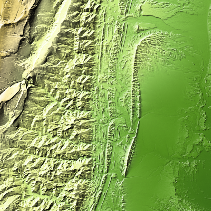
TanDEM-X - Edited Digital Elevation Model (EDEM) - Global, 30m
TanDEM-X (TerraSAR-X add-on for Digital Elevation Measurements) is an Earth observation radar mission that consists of a SAR interferometer built by two almost identical satellites flying in close formation. With a typical separation between the satellites of 120 m to 500 m a global Digital Elevation Model (DEM) has been generated.
The TanDEM-X 30m EDEM is a product variant of the global Digital Elevation Model (DEM) acquired in the frame of the German TanDEM-X mission between 2010 and 2014, and has a reduced pixel spacing of 1 arcseconds (arsec), which corresponds to 30m at the equator. An automated edition was developed by the Microwaves and Radar Institute at the German Aerospace Center (DLR) to have a full and clean coverage of all Earth’s landmasses from pole to pole.
INSPIRE
Identification
- File identifier
- 4ee664df-ceb9-4d59-bc6e-4df4da54b53d XML
- Hierarchy level
- Dataset
Online resource
- Protocol
-
WWW:LINK-1.0-http--link
- Protocol
-
WWW:LINK-1.0-http--link
- Protocol
-
WWW:LINK-1.0-http--link
- Protocol
-
WWW:LINK-1.0-http--link
- Protocol
-
OGC:WMS
- Protocol
-
OGC:WMS
- Protocol
-
OGC:WMS
- Protocol
-
OGC:WMS
- Protocol
-
OGC:WMS
- Protocol
-
OGC:WMS
- Protocol
-
OGC:WMS
- Protocol
-
WWW:LINK-1.0-http--link
Resource identifier
- Metadata language
- English
- Spatial representation type
- Grid
Encoding
- Format
-
GeoTIFF
Projection
- code
- EPSG:4326
Classification of data and services
- Topic category
-
- Elevation
Classification of data and services
Coupled resource
Coupled resource
Classification of data and services
Coupled resource
Coupled resource
Keywords
-
GEMET - INSPIRE themes, version 1.0
-
-
Elevation
-
Other keywords
- Keywords
-
-
DLR
-
TDM
-
HR
-
TanDEM-X
-
EDEM
-
DEM
-
Digital Elevation Model
-
TDX-1
-
TSX-1
-
TDM 30m EDEM
-
Edited DEM
-
Global
-
Geographic coverage
))
Temporal reference
Temporal extent
- Begin
- 2010-12-12T04:04:33
- End
- 2015-01-16T00:37:12
Temporal extent
- Date (Creation)
- 2023-11-17T12:00:00
Quality and validity
- Lineage
-
TDM 30 EDEM has been edited using the following DEMs for filling gaps are AW3D30, Nasadem, Lidar, REMA DEM and Arctic DEM.
- Denominator
- 60000
Conformity
Conformity
Conformity
Conformity
Conformity
Conformity
- Explanation
-
See the referenced specification
Restrictions on access and use
- Access constraints
- Öffentlicher Zugriff beschränkt entsprechend Artikel 13(1)(e) der INSPIRE-Richtlinie: e) aufgrund nachteiliger Auswirkungen auf die Rechte des geistigen Eigentums
- Access constraints
-
Nutzungsbedingungen: https://geoservice.dlr.de/resources/licenses/tdm30-edited/License_for_the_Utilization_of_TanDEM-X_30m-EDEM_DCM_for_Scientific_Use.pdf Terms of Use: https://geoservice.dlr.de/resources/licenses/tdm30-edited/License_for_the_Utilization_of_TanDEM-X_30m-EDEM_DCM_for_Scientific_Use.pdf
Responsible organization (s)
Contact for the resource
- Organisation name
-
German Aerospace Center (DLR)
- Organisation name
-
German Aerospace Center (DLR)
Responsible organization (s)
Contact for the resource
- Organisation name
-
German Aerospace Center (DLR)
- Organisation name
-
German Aerospace Center (DLR)
Metadata information
Contact for the metadata
- Organisation name
-
German Aerospace Center (DLR)
- Date stamp
- 2024-06-27T14:44:46
- Metadata language
- English
- Character set
- UTF8
SDS
Conformance class 1: invocable
Access Point URL
Endpoint URL
Technical specification
Conformance class 2: interoperable
Access constraints
Limitation
Use constraints
Limitation
Responsible custodian
Contact for the resource
Overviews
Spatial extent
Provided by
