 www.geodatenkatalog.de (S1L)
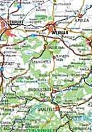
Übersichtskarte 1: 600 000
Das Thüringer Landesamt für Bodenmanagement und Geoinformation hat eine top. Übersichtskarte von Thüringen im Maßstab 1:600 000 ( ÜK Th 600 ) herausgegeben. Der Maßstab wurde der analogen Karte im Format DIN A3 ( 297 x 420 mm ) angepasst. Eine kleine Legende erläutert die Bedeutung von Zeichen und Beschriftungen. Die Karte zeigt im nordöstlichen Teil die Städte Halle und Leipzig mit ihren Verkehrsverbindungen, was für den Kraftfahrer eine Hilfe sein kann. Natürlich fehlen auch nicht die freigegebenen Thüringer Autobahnabschnitte der A71 und A38.
|
|
Citation proposal
. Übersichtskarte 1: 600 000. https://gdk.gdi-de.org/geonetwork/srv/api/records/51aa65eb-c229-41ea-8084-608f6e0b11b7 |
INSPIRE
Identification
- File identifier
- 51aa65eb-c229-41ea-8084-608f6e0b11b7 XML
- Hierarchy level
- Dataset
Online resource
Resource identifier
- Metadata language
- German
- Spatial representation type
- Grid
Encoding
- Format
- Version
- keine
Projection
- code
- EPSG:25832
Classification of data and services
- Topic category
-
- Imagery base maps earth cover
Classification of data and services
Coupled resource
Coupled resource
Classification of data and services
Coupled resource
Coupled resource
Keywords
Other keywords
- Keywords
-
- Grenze
- Übersichtskarte
- Karte
- GOVE
- opendata
Geographic coverage
N
S
E
W
))
Temporal reference
Temporal extent
Temporal extent
- Date ( Revision )
- 2024-01-01
Quality and validity
- Lineage
- stark vereinfachte Topographie und die Landesgrenze des Freistaates
- Distance
- 1 m
Conformity
Conformity
Conformity
Conformity
Conformity
Conformity
Restrictions on access and use
- Access constraints
- { "id": "dl-by-de/2.0", "name": "Datenlizenz Deutschland Namensnennung 2.0", "url": "https://www.govdata.de/dl-de/by-2-0", "quelle": "© GDI-Th" }
Restrictions on access and use
Responsible organization (s)
Contact for the resource
- Organisation name
- Thüringer Landesamt für Bodenmanagement und Geoinformation
Responsible organization (s)
Contact for the resource
- Organisation name
- Thüringer Landesamt für Bodenmanagement und Geoinformation
Metadata information
Contact for the metadata
- Organisation name
- Thüringer Landesamt für Bodenmanagement und Geoinformation
- Date stamp
- 2024-11-19T11:13:27
- Metadata language
- German
- Character set
- UTF8
SDS
Conformance class 1: invocable
Access Point URL
Endpoint URL
Technical specification
Conformance class 2: interoperable
Coordinate reference system
Quality of Service
Access constraints
Limitation
Use constraints
Limitation
Responsible custodian
Contact for the resource
Conformance class 3: harmonized
Overviews
Provided by

Views
51aa65eb-c229-41ea-8084-608f6e0b11b7
Access to the portal
Read here the full details and access to the data.
Associated resources
Not available