 My GeoNetwork catalogue
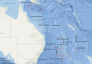
Processed seismic data of Cruise SO7 1978
In the period from October 16, 1978 to December 9, 1978 geophysical investigations have been carried out on SONNE cruises SO-7A and SO-7B on the Lord Howe Rise off eastern Australia and in the northern Coral Sea by the Federal Institute for Geosciences and Natural Resources (Hannover) in co-operation with the Bureau of Mineral Resources, Geology & Geophysics (Canberra), Department of Scientific and Industrial Research (Wellington), Geological Survey of Papua New Guinea (Port Moresby). A total of 10,500 km of bathymetric, magnetic and gravity profiles, 7,000 km of digital seismic reflection profiles and 50 sonobuoy refraction profiles were recorded during this survey. Objective of cruise SO-7A was to determine the depth and nature of the basement of the Lord Howe Rise, the configuration of the early rift basin, and the thickness and internal structure of the enclosed sediments. A new sea-mount in the southern Norfolk Basin rising some 2200 m above sea floor characterized by a free air anomaly of about 80 mgal and by a magnetic anomaly of some 500 nT was found. A complex horst and graben zone often associated with volcanic intrusions underlies the western flank of the Lord Howe Rise. Within some grabens the "breakup"-unconformity seems to exist, supporting the model that the Lord Howe Rise and the Dampier Ridge were once part of the Australian continent. The thickness of pre-breakup sediments is normally small on the Lord Howe Rise. Only in some grabens the thickness of these sediments exceeds 1 second reflection time. The Oligocene/Eocene unconformity and a Miocene unconformity are clearly recognizable in all our seismic records. Best explanation of these unconformities seems to be relative falls in sea level due to swelling and subsidences of oceanic crust. Strong variations in the character of the acoustic basement have been observed. Besides blocks with flat-lying acoustic basement zones with hummocky and irregular basement surface exist which may relate to areas of stretched continental basement contaminated by basaltic intrusions. The eastern edge of the Lord Howe Rise is characterized by an edge anomaly rising to +1000 nT. The general magnetic and gravity features of the western flank of Lord Howe Rise and the Dampier Ridge are: A generally quiet magnetic field with isolated large anomalies, consistent with the faulted acoustic basement of low or moderate susceptibility, with low susceptibility, dense intrusives in places, and also high susceptibility intrusions or flows. Gravimetric/magnetic "edge anomalies" between the outer and western edge of the Lord Howe/Dampier Ridge and the Tasman Sea are apparently absent. The objective of cruise SO-7B was to search for marginal graben zones off the Queensland and Papuan Plateaus associated with the initial rifting of the Coral Sea Basin. In the seismic records at least two regional unconformities are recognizable which represent periods of erosion or non-deposition during Oligocene/Eocene respectively in Miocene time. Further an older unconformity exists in block-faulted regions of the Queensland and Papuan Plateaus. Beneath the present continental slopes the Miocene and Oligocene/Eocene unconformities lie close together and are sometimes coincident. The transition from oceanic crust of the Coral Sea Basin to continental crust of the Queensland and Papuan Plateaus occurs in the surveyed area over a narrow ( 50 km) zone and is associated with a sediment filled graben. The graben-zone observed beneath the present slope of the Queensland and Papuan Plateaus contains more than 2 sec (reflection time) thick sediments of pre-Oligocene/Eocene age. The oceanic crust, as it approaches the plateaus, either rapidly deepens or abruptly stops and/or changes its seismic character so as not to be recognizable. In the seismic records from the outer part and slope of the Queensland and Papuan Plateaus, 5 to 10 km wide, convex, reflectionless zones exist. These features are interpreted as drowned fossil reefs. All observed reefs lie beneath the Oligocene/Eocene unconformity indicating these present deep-water areas were at shallow depths in pre-Eocene time. In the surveyed area post-Oligocene fossil reefs do not exist suggesting these areas were already at upper bathyal depths in the Oligocene. Assuming a seismic velocity for reefal material of 4000 m/s, the reefs on the outer Papuan Plateau have an approximate thickness of 3000 meters. Assuming a reef-growth rate of 25 m/m.y. the growth of the reefs started in upper Jurassic time (120 m.y. + 29 m.y. (assumed age of the Oligocene/Eocene unconformity) yields to 149 m.y.). The basement of the Papuan and Queensland Plateaus is probably crystalline Paleozoic rocks. This is suggested for the Queensland Plateau in particular by their relatively shallow depth, refraction velocities of 6.0 - 6.3 km/s (Ewing et al.) and 5.0 (this survey) and high intensity magnetics. A complex system of horst and graben structures exist on the Queensland and Papuan Plateaus. A larger graben appears to trend in an East-West direction on the southern Papuan Plateau. This graben is about 1 second (reflection time) deep and varies in width from 5 to 20 km.
INSPIRE
Identification
- File identifier
- 51ecf986-b28f-4223-9a4c-901471e1f53b XML
- Hierarchy level
- Dataset
Online resource
Resource identifier
- code
-
d67bae80-cd43-5635-d417-7bc592f7f6d0
- Metadata language
- English
- Spatial representation type
- Vector
Encoding
- Format
-
Shapefile
- Version
-
n/a
Projection
- code
- EPSG:4326
Classification of data and services
- Topic category
-
- Geoscientific information
Classification of data and services
Coupled resource
Coupled resource
Classification of data and services
Coupled resource
Coupled resource
Keywords
-
GEMET - INSPIRE themes, version 1.0
-
-
Geologie
-
geology
-
-
GEMET - Concepts, version 2.4
-
-
geophysics
-
Geophysik
-
raw material
-
Rohstoff
-
Other keywords
- Theme
-
-
Marine geology
-
Meeresgeologie
-
Seismics
-
Seismik
-
Two-dimensional seismic reflection
-
zweidimensionale Reflektionsseismik
-
- Place
-
-
Norfolk Basin
-
Norfolk Becken
-
Dampier Ridge
-
Lord Howe Rise
-
Lord Howe Rücken
-
Korallensee
-
Coral Sea
-
Geographic coverage
))
Temporal reference
Temporal extent
Temporal extent
- Date (Creation)
- 1978-12-09
Quality and validity
- Lineage
-
In the period from October 16, 1978 to December 9, 1978 BGR acquired seismic lines at the Lord Howe Rise and in the northern Coral Sea during cruises SO-7A and SO-7B with RV SONNE. The lines SO7-01, SO7-01A, SO7-02, SO7-03, SO7-04, SO7-05, SO7-06, SO7-07, SO7-07A, SO7-08, SO7-09, SO7-10, SO7-12, SO7-12A, SO7-19, SO7-19A, SO7-19B, SO7-20, SO7-20A and SO7-21 consist of raw data.
Conformity
Conformity
Conformity
Conformity
Conformity
Conformity
- Explanation
-
siehe dazu die angegebene Durchführungsbestimmung
Restrictions on access and use
- Access constraints
- Es gelten keine Zugriffsbeschränkungen
- Access constraints
-
Allgemeine Geschäftsbedingungen, siehe http://www.bgr.bund.de/AGB - General terms and conditions, see http://www.bgr.bund.de/AGB_en . Die bereitgestellten Informationen sind bei Weiterverwendung wie folgt zu zitieren: Datenquelle: SO7 1978, (c) BGR, Hannover, 2019
Responsible organization (s)
Contact for the resource
- Organisation name
-
Federal Institute for Geosciences and Natural Resources
Responsible organization (s)
Contact for the resource
- Organisation name
-
Federal Institute for Geosciences and Natural Resources
Metadata information
Contact for the metadata
- Organisation name
-
Bundesanstalt für Geowissenschaften und Rohstoffe (BGR)
- Date stamp
- 2023-11-16
- Metadata language
- English
- Character set
- UTF8
SDS
Conformance class 1: invocable
Access Point URL
Endpoint URL
Technical specification
Conformance class 2: interoperable
Access constraints
Limitation
Use constraints
Limitation
Responsible custodian
Contact for the resource
Overviews
Spatial extent
Provided by
