 www.geodatenkatalog.de (S3L)
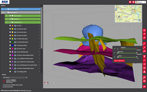
BGR's 3D web viewer
BGR's 3D web viewer allows for a visualisation of the its produced 3D subsurface models from various perspectives and camera positions by using only a web browser. Each of the geologic horizons of a model can be separately switched on and off. The information belonging to a horizon can be queried by clicking with the mouse on the displayed object. The user can chose which model data are to be exported, thereby loading the data to the own computer. Predefined camera positions give a quick access to the visualisation of a model. The web application offers essential tools to explore the 3D model such as rotation, zoom and panning functions, or adjustment of the exaggeration in vertical direction. Additionally, the user has the choice between different topographic data which can be put on top of the model. By means of the slicer function parts of the model can be blanked out, so the user gains more detailed insights into the model. Moreover, virtual boreholes and profile sections can be interactively created. Filter functions, spatial measuring tools and storing of scalable screen shots complete the functionalities. Further hints for the usage of the web application are found on the graphical user interface.
|
|
Citation proposal
(2021) . BGR's 3D web viewer. https://gdk.gdi-de.org/geonetwork/srv/api/records/51f1a27c-51f1-4c80-9b85-21e9ce26c4d1 |
INSPIRE
Identification
- File identifier
- 51f1a27c-51f1-4c80-9b85-21e9ce26c4d1 XML
- Hierarchy level
- application
Online resource
Resource identifier
- code
- af8be89e-cbd6-a5f2-facb-eb4a06d4dc82
- Metadata language
- German
Encoding
- Format
- Webapplication
- Version
- n/a
Projection
Classification of data and services
- Topic category
-
- Geoscientific information
Classification of data and services
Coupled resource
Coupled resource
Classification of data and services
Coupled resource
Coupled resource
Keywords
Other keywords
- Keywords ( Theme )
-
- Geologie
- 3D-Untergrundmodelle
- virtuelle Bohrungen
- virtuelle Profilschnitte
- TUNB
- Norddeutsches Becken
Geographic coverage
N
S
E
W
))
Temporal reference
Temporal extent
Temporal extent
- Date ( Publication )
- 2021-01-28
Quality and validity
- Lineage
- Bereitstellung und Pflege durch den Bereich Geodatenmanagement der Bundesanstalt für Geowissenschaften und Rohstoffe (BGR)
Conformity
Conformity
Conformity
Conformity
Conformity
Conformity
Restrictions on access and use
- Access constraints
- Allgemeine Geschäftsbedingungen, siehe https://www.bgr.bund.de/AGB - General terms and conditions, see https://www.bgr.bund.de/AGB_en. Die bereitgestellten Informationen sind bei Weiterverwendung wie folgt zu zitieren: Datenquelle: BGR-3D-Viewer, (c) BGR, Hannover, 2021
Restrictions on access and use
Responsible organization (s)
Contact for the resource
- Organisation name
- Bundesanstalt für Geowissenschaften und Rohstoffe (BGR)
Responsible organization (s)
Contact for the resource
- Organisation name
- Bundesanstalt für Geowissenschaften und Rohstoffe (BGR)
Metadata information
Contact for the metadata
- Organisation name
- Bundesanstalt für Geowissenschaften und Rohstoffe (BGR)
- Date stamp
- 2021-07-15
- Metadata language
- German
- Character set
- UTF8
SDS
Conformance class 1: invocable
Access Point URL
Endpoint URL
Technical specification
Conformance class 2: interoperable
Coordinate reference system
Quality of Service
Access constraints
Limitation
Use constraints
Limitation
Responsible custodian
Contact for the resource
Conformance class 3: harmonized
Overviews
Provided by

Views
51f1a27c-51f1-4c80-9b85-21e9ce26c4d1
Access to the portal
Read here the full details and access to the data.
Associated resources
Not available