 www.geodatenkatalog.de (S3L)
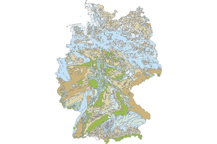
Hydrogeology of Germany 1:1,000,000 (HY1000)
In the map, all strata are first classified in the four main types “pore aquifers”, “combined pore and fractured aquifers”, “fractured and karst aquifers” and “aquitards and aquicludes”. Further differentiation is made depending on the areal extent and productivity of the aquifers according to the classification of the Standard Legend for Hydrogeological Maps (SLHyM). The productivity classes have been derived from permeability values. In addition, the surface strata are divided into 19 different types of consolidated or unconsolidated rocks and four types of covering layers. Furthermore, the map shows salinity zones of near-surface groundwater in inland areas, as well as zones of saltwater intrusions along the coast. Areas in which groundwater is affected by mining are also shown. The map “Hydrogeology” is based on the digital Geological Map of Germany 1:1,000,000 (GK1000) published by BGR in 1993. The digital GK1000 contains attributes for the stratigraphy, lithology and genesis of the rocks.
|
|
Citation proposal
(2019) . Hydrogeology of Germany 1:1,000,000 (HY1000). https://gdk.gdi-de.org/geonetwork/srv/api/records/53656EEE-00DC-4C65-ABDA-F097F86ACC20 |
Simple
- Alternate title
- HY1000
- Date ( Publication )
- 2019-08-15
- Edition
- v1.0
- Identifier
- F4BDC436-6A7E-4D7D-87A3-51F95ED2716B
Author
Author
- Other citation details
- HY1000 (c) BGR Hannover 2019
- Status
- completed Completed
Point of contact
- GEMET - INSPIRE themes, version 1.0 ( Theme )
-
- Geologie
- GEMET - Concepts, version 2.4 ( Theme )
-
- Grundwasser
- Hydrogeologie
- Keywords ( Theme )
-
- Hydrogeologie von Deutschland
- HAD
- HAD 1.6
- HK1000
- Keywords ( Place )
-
- Deutschland
- Access constraints
- Other restrictions
- Use constraints
- Other restrictions
- Other constraints
- Allgemeine Geschäftsbedingungen, siehe https://www.bgr.bund.de/AGB - General terms and conditions, see https://www.bgr.bund.de/AGB_en. Die bereitgestellten Informationen sind bei Weiterverwendung wie folgt zu zitieren: Datenquelle: HY1000 (c) BGR Hannover 2019
- Spatial representation type
- Vector
- Denominator
- 1000000
- Metadata language
- ger German
- Character set
- utf8 UTF8
- Topic category
-
- Geoscientific information
N
S
E
W
))
- Geographic identifier
- Regionalschlüssel / 000000000000
- Distribution format
-
- Shapefile (n/a )
- Transfer size
- 27
- OnLine resource
-
HY1000 (Shapefile)
HY1000 im Format ESRI Shape
- OnLine resource
-
Informationen zum Projekt HAD und Bezugsquelle der gedruckten Atlastafel - Information about the project and supply of the printed edition
Informationen zum Projekt HAD und Bezugsquelle der gedruckten Atlastafel - Information about the project and supply of the printed edition
- OnLine resource
-
Karte im BGR-Geoviewer
Karte im BGR-Geoviewer
- Hierarchy level
- Dataset
- Statement
- Geologische Karte von Deutschland 1:1.000.000 (GK1000).
gmd:MD_Metadata
- File identifier
- 53656EEE-00DC-4C65-ABDA-F097F86ACC20 XML
- Metadata language
- German
- Character set
- utf8 UTF8
- Hierarchy level
- dataset Dataset
- Hierarchy level name
- Grundwasser
- Date stamp
- 2025-03-07
- Metadata standard name
- INSPIRE Metadata Implementing Rules: Technical Guidelines based on EN ISO 19115 and EN ISO 19119
- Metadata standard version
- n/a
Point of contact
Overviews
Provided by

Views
53656EEE-00DC-4C65-ABDA-F097F86ACC20
Access to the portal
Read here the full details and access to the data.
Associated resources
Not available