 www.geodatenkatalog.de (S3L)
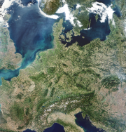
MODIS - Image Mosaic - Germany
The Moderate Resolution Imaging Spectroradiometer (MODIS) is a key instrument aboard the Terra (EOS AM-1) and Aqua (EOS PM-1) satellites. Terra's orbit around the Earth is timed so that it passes from north to south across the equator in the morning, while Aqua passes south to north over the equator in the afternoon. Terra MODIS and Aqua MODIS are viewing the entire Earth's surface every 1 to 2 days, acquiring data in 36 spectral bands, or groups of wavelengths (see MODIS Technical Specifications).
This mosaic has been generated from Terra and Aqua products acquired between 30 September and 03 October 2011.
|
|
Citation proposal
German Aerospace Center (DLR). MODIS - Image Mosaic - Germany. https://gdk.gdi-de.org/geonetwork/srv/api/records/53da0644-f6ef-4720-a824-ebcde9467234 |
INSPIRE
Identification
- File identifier
- 53da0644-f6ef-4720-a824-ebcde9467234 XML
- Hierarchy level
- Dataset
Online resource
- Protocol
- OGC:WMS
- Protocol
- OGC:WCS
- Protocol
- OGC:WMS-http-get-capabilities
- Protocol
- WWW:LINK-1.0-http--link
Resource identifier
- Metadata language
- English
- Spatial representation type
- Grid
Encoding
- Format
- Version
Projection
Classification of data and services
- Topic category
-
- Imagery base maps earth cover
Classification of data and services
Coupled resource
Coupled resource
Classification of data and services
Coupled resource
Coupled resource
Keywords
- GEMET - INSPIRE themes, version 1.0 ( Theme )
-
- Orthoimagery
- Spatial scope ( Place )
Other keywords
- Keywords
-
- MODIS
- MODIS-DE
- Aqua
- Terra
- Moderate Resolution Imaging Spectroradiometer
- Mosaic
- visual wavelengths
- Germany
- DLR-DFD
Geographic coverage
N
S
E
W
))
Temporal reference
Temporal extent
Temporal extent
- Date ( Creation )
- 2011-01-13T00:00:00
Quality and validity
- Lineage
- Please refer to https://www.dlr.de/de/eoc/forschung-transfer/themen/aktuelle-wetterbilder/modis-eu for more details. The MODIS data used in this product were obtained through the online Data Pool at the NASA Land Processes Distributed Active Archive Center (LP DAAC), USGS/Earth Resources Observation and Science (EROS) Center, Sioux Falls, South Dakota (https://lpdaac.usgs.gov/get_data).
- Denominator
- 500000
Conformity
Conformity
Conformity
Conformity
Conformity
Conformity
- Explanation
- See the referenced specification
Restrictions on access and use
- Access constraints
- Nutzungsbedingungen: Copyright
Restrictions on access and use
Responsible organization (s)
Contact for the resource
- Organisation name
- German Aerospace Center (DLR)
- geoservice@dlr.de
- Organisation name
- German Aerospace Center (DLR)
- geoservice@dlr.de
Responsible organization (s)
Contact for the resource
- Organisation name
- German Aerospace Center (DLR)
- geoservice@dlr.de
- Organisation name
- German Aerospace Center (DLR)
- geoservice@dlr.de
Metadata information
Contact for the metadata
- Organisation name
- German Aerospace Center (DLR)
- geoservice@dlr.de
- Date stamp
- 2024-07-09T13:24:19
- Metadata language
- English
- Character set
- UTF8
SDS
Conformance class 1: invocable
Access Point URL
Endpoint URL
Technical specification
Conformance class 2: interoperable
Coordinate reference system
Quality of Service
Access constraints
Limitation
Use constraints
Limitation
Responsible custodian
Contact for the resource
Conformance class 3: harmonized
Overviews

large_thumbnail
thumbnail
Provided by

Views
53da0644-f6ef-4720-a824-ebcde9467234
Access to the portal
Read here the full details and access to the data.
Associated resources
Not available