 www.geodatenkatalog.de (S2F)
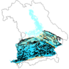
Malm - Verbreitung, Tiefenlage und Faziesverteilung
Die Karte zeigt die Verbreitung des an der Erdoberfläche ausstreichenden Malm, die Tiefenlage der Purbeck- bzw. Malmoberfläche in Meter unter Normalnull sowie die als Stützpunkte verwendeten Bohrungen, Störungen im Bereich der Malmoberfläche, den Umgriff möglicher malmfreier Gebiete auf dem Landshuter-Neuöttinger-Hoch (LNH), die tektonischen Grenzen zur Faltenmolasse bzw. zu den alpinen Decken, den Umriss des Nördlinger Rieses sowie die Faziesverteilung im Malm.
Die Geometrien sind für den Betrachtungsmaßstab 1:500.000 konzipiert und teilweise generalisiert.
Die Karte bietet die Möglichkeit, für einen gegebenen Standort die Tiefenlage der Malmoberfläche bestimmen und für diese Tiefenlage aus den Temperaturkarten die zu erwartenden Temperaturen abschätzen zu können. Sie ersetzt nicht die Durchführung von Detailuntersuchungen.
|
|
Citation proposal
. Malm - Verbreitung, Tiefenlage und Faziesverteilung. https://gdk.gdi-de.org/geonetwork/srv/api/records/552a998a-6284-4147-9f71-a3c9fc375591 |
INSPIRE
Identification
- File identifier
- 552a998a-6284-4147-9f71-a3c9fc375591 XML
- Hierarchy level
- dataset Dataset
Online resource
Resource identifier
- Metadata language
- German
- Spatial representation type
- Vector
Encoding
- Format
- GDB
Projection
Classification of data and services
- Topic category
-
- Environment
- Geoscientific information
Classification of data and services
Coupled resource
Coupled resource
Classification of data and services
Coupled resource
Coupled resource
Keywords
Other keywords
- Keywords
-
- UmweltAtlas
- Störungen
- Nördlinger Ries
- Purbeck-/Malmoberfläche
- Jura
- Malm
- Geologie
- gdiby
- opendata
- Keywords ( Theme )
-
- ENVI
Geographic coverage
))
Temporal reference
Temporal extent
Temporal extent
- Date ( Revision )
- 2022-10-28T00:00:00.000+02:00
Quality and validity
- Lineage
- Dieser Datenbestand wurde im Rahmen der Darstellung des Themenbereiches Tiefe Geothermie erstellt.
- Denominator
- 5000000
Conformity
Conformity
Conformity
Conformity
Conformity
Conformity
Restrictions on access and use
- Access constraints
- Creative Commons Namensnennung 4.0 International (CC BY 4.0); Datenquelle: Bayerisches Landesamt für Umwelt, www.lfu.bayern.de; Die Nutzung von Daten über Dienste ist geldleistungsfrei. Bei Bezug von Daten über die Datenstelle des LfU (nur Daten, die nicht über Dienste verfügbar sind) wird eine Bereitstellungsgebühr erhoben, die sich an der Umweltgebührenordnung orientiert.
- Access constraints
- {"id":"cc-by/4.0","name":"Creative Commons Namensnennung 4.0 International (CC BY 4.0)","url":"https://creativecommons.org/licenses/by/4.0/deed.de","quelle":"Bayerisches Landesamt für Umwelt, www.lfu.bayern.de"}
Restrictions on access and use
Responsible organization (s)
Contact for the resource
- Organisation name
- Bayerisches Landesamt für Umwelt
- Organisation name
- Bayerisches Landesamt für Umwelt
Responsible organization (s)
Contact for the resource
- Organisation name
- Bayerisches Landesamt für Umwelt
- Organisation name
- Bayerisches Landesamt für Umwelt
Metadata information
Contact for the metadata
- Organisation name
- Bayerisches Landesamt für Umwelt
- Date stamp
- 2024-08-01
- Metadata language
- German
- Character set
- UTF8
SDS
Conformance class 1: invocable
Access Point URL
Endpoint URL
Technical specification
Conformance class 2: interoperable
Coordinate reference system
Quality of Service
Access constraints
Limitation
Use constraints
Limitation
Responsible custodian
Contact for the resource
Conformance class 3: harmonized
Overviews
Provided by
