 www.geodatenkatalog.de (S2L)
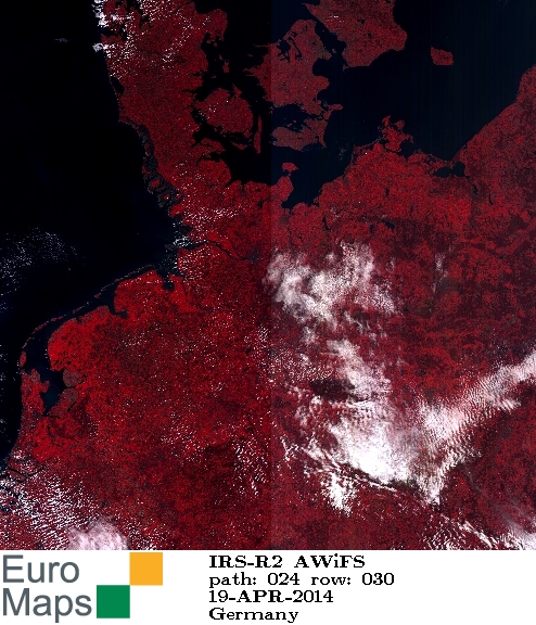
Resourcesat-2 - Wide Field Sensor Images (AWiFS) - Europe
Indian Remote Sensing satellites (IRS) are a series of Earth Observation satellites, built, launched and maintained by Indian Space Research Organisation. The IRS series provides many remote sensing services to India and international ground stations.
The revisit capability of only 5 days and the products coverage size of 370 km x 370 km make AWiFS products a valuable source for application fields such forestry and environmental monitoring
|
|
Citation proposal
GAF AG. Resourcesat-2 - Wide Field Sensor Images (AWiFS) - Europe. https://gdk.gdi-de.org/geonetwork/srv/api/records/57485ff5-8523-4251-9d01-2f497a31cc48 |
- Identification
- Distribution
- Quality
- Spatial rep.
- Ref. system
- Content
- Portrayal
- Metadata
- Md. constraints
- Md. maintenance
- Schema info
Identification
Data identification
Citation
- Date ( Creation )
- 2015-01-08T00:00:00
- Edition
- Presentation form
- Digital map
- Status
- On going
Point of contact
Author
- Maintenance and update frequency
- Not planned
- GEMET - INSPIRE themes, version 1.0 ( Theme )
-
- Orthoimagery
- Spatial scope ( Theme )
- Keywords
-
- urn:eop:DLR:EOWEB:IRS-R2.AWiFS.P
- IRS-R2.AWiFS.P
- IRS-R2
- AWiFS
- Resourcesat-2
- visible wavelengths
- infrared wavelengths
- FEDEO
- Use limitation
- Nutzungseinschränkungen: Das DLR ist nicht haftbar für Schäden, die sich aus der Nutzung ergeben. / Use Limitations: DLR not liable for damage resulting from use.
Legal constraints
- Access constraints
- Other restrictions
Legal constraints
- Use constraints
- Other restrictions
- Other constraints
- Nutzungsbedingungen / Terms of Use: https://geoservice.dlr.de/resources/licenses/D-SDA_DataLicenseTerms.pdf
- Spatial representation type
- Grid
- Denominator
- 112000
- Metadata language
- eng
- Character set
- UTF8
- Topic category
-
- Imagery base maps earth cover
Extent
N
S
E
W
))
Distribution
Distribution
- Distribution format
-
- ()
Digital transfer options
- OnLine resource
-
IRS-R2.AWiFS.P
EOWEB Collection
- OnLine resource
- Euromap Homepage
Quality
Data quality
- Hierarchy level
- Series
Domain consistency
- Measure identification
- INSPIRE / Conformity_001
Conformance result
Citation
- Date ( Publication )
- 2010-12-08
- Explanation
- See the referenced specification
Lineage
- Statement
- For details see: https://www.euromap.de/site/index.html
- Description
- Browse processing
Ref. system
- Reference system identifier
- EPSG / WGS 84 (EPSG:4326) / 7.4
Metadata
Metadata
- File identifier
- 57485ff5-8523-4251-9d01-2f497a31cc48 XML
- Metadata language
- English
- Character set
- UTF8
- Hierarchy level
- Series
- Hierarchy level name
- Dataseries
- Date stamp
- 2024-09-27T12:48:43
- Metadata standard name
- ISO 19115:2003/19139
- Metadata standard version
- 1.0
Point of contact
Overviews
large_thumbnail

thumbnail
Provided by

Views
57485ff5-8523-4251-9d01-2f497a31cc48
Access to the portal
Read here the full details and access to the data.
Associated resources
Not available