 www.geodatenkatalog.de (S3L)
WMS Sentinel2 Deutschland
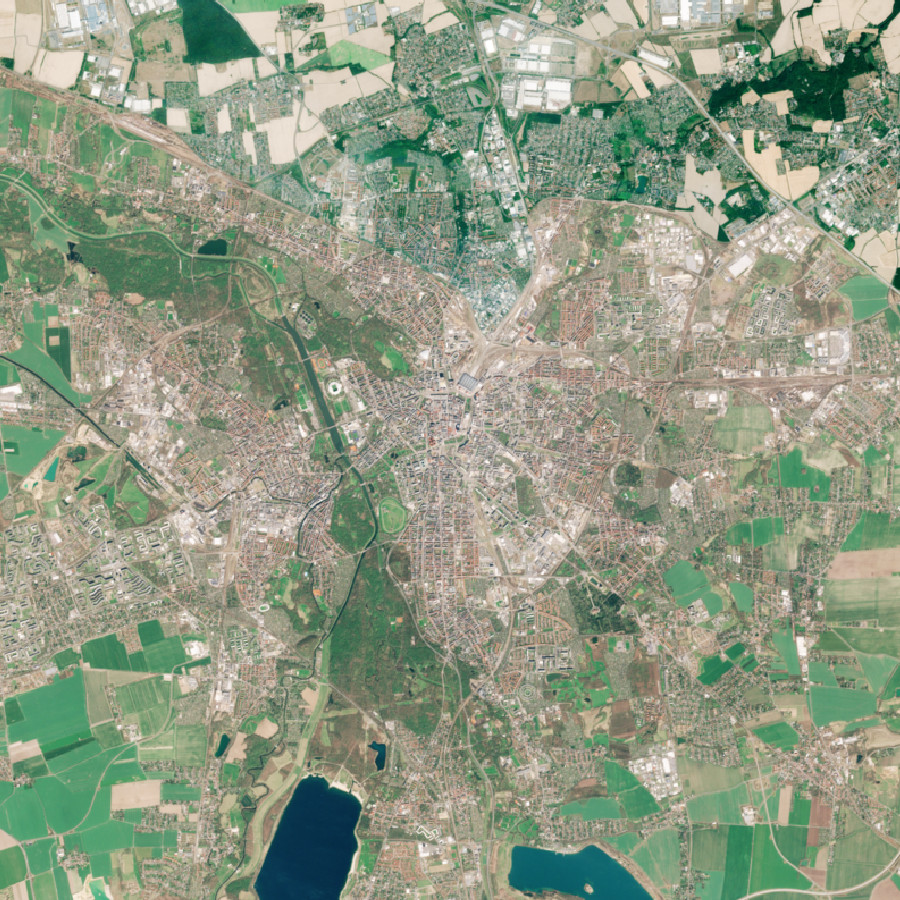
Das Bundesamt für Kartographie und Geodäsie (BKG) hat ein Verfahren zur bedarfsbezogenen Bereitstellung von Fernerkundungsdaten entwickelt. Für die fernerkundliche Produktion werden derzeit optische Satellitenbilddaten in der Bundesverwaltung bevorzugt eingesetzt. Hierfür ist das sogenannte Mosaik-Verfahren eine wichtige Methode. Das Verfahren wurde mit den von der EU finanzierten Sentinel-2- Daten der europäischen Erdbeobachtungsinitiative Copernicus aufgebaut und kann für jeden optischen Datensatz (inkl. Luftbilder) angewendet werden. Wir stellen mit dieser Methode einen Service zur Verfügung, über den sich optische Fernerkundungsdaten für jedes Gebiet auf der Erde fachlich und bedarfsorientiert aufbereiten lassen.
Über diesen Dienst wird den Bedarfsträgern ermöglicht, vorprozessierte und aufbereitete Fernerkundungsinformationen aus dem Erdbeobachtungsprogramm Copernicus (Sentinel-2, L1C-L2A), für die Bundesrepublik Deutschland, in bestehende eigene Fachverfahren mit einzubinden. Die Bilddaten der Jahre 2018 bis 2021 wurden jeweils zu einem Mosaik zusammengefügt, welches eine Bodenauflösung von 10 m hat. Drei Komposite aus fünf Bändern (Sentinel-2 Bänder: 2, 3, 4, 5 und 8, bzw. R, G, B, Red Edge und NIR) sowie eine Information zu den Eingangsbilddaten werden angeboten. Über ein Resampling-Verfahren ist die ursprüngliche Auflösung des Kanals 5 (20 m) auf 10 m gerechnet. Die Wolkenbedeckung für das Mosaik beträgt über das gesamte Gebiet weniger als 3%.
Es werden separate Layer für die verschiedenen Jahresstände bereitgestellt (z.B. Layers=rgb_2019 oder Layers=nirrer_2020). Alle Jahresstände sind zudem in den drei Layern rgb, nir und nirrer kombiniert. Über den Request-Parameter TIME kann hier gezielt ein spezifischer Jahresstand angezeigt werden (z.B. Time=2018) (ohne TIME-Parameter wird der neueste Stand angezeigt). Bodenauflösung: 10m
|
|
Citation proposal
. WMS Sentinel2 Deutschland. https://gdk.gdi-de.org/geonetwork/srv/api/records/57B654B9-D96C-4916-B056-0B2776126C4E |
INSPIRE
Identification
- File identifier
- 57B654B9-D96C-4916-B056-0B2776126C4E XML
- Hierarchy level
- service Service
Online resource
Resource identifier
Encoding
- Format
- TIFF
- Format
- PNG
- Format
- JPEG
Projection
- code
- CRS 84: CRS 84 / mathematisch
Classification of data and services
Classification of data and services
- Service Type
- view
- Coupling Type
- Tight
Coupled resource
Coupled resource
Classification of data and services
- Service Type
- view
- Coupling Type
- Tight
Coupled resource
Coupled resource
Keywords
- GEMET - Concepts, version 3.1 ( Theme )
- Service Classification, version 1.0 ( Theme )
-
- infoMapAccessService
Other keywords
- Keywords
-
- Copernicus
- 2018
- Deutschland
- Multispektral
- Sentinel2
- BKG
- Satellitenbildkarte
- Sentinel
- WMS
- Bundesamt für Kartographie und Geodäsie
- 2019
- 2020
- 2021
- Hintergrundkarte
Geographic coverage
))
))
Temporal reference
Temporal extent
Temporal extent
- Date ( Creation )
- 2019-03-25T00:00:00.000+01:00
- Date ( Revision )
- 2022-02-22T00:00:00.000+01:00
Quality and validity
Conformity
Conformity
Conformity
Conformity
Conformity
Conformity
- Explanation
- see the referenced specification
Restrictions on access and use
Restrictions on access and use
- Access constraints
- Die Daten sind urheberrechtlich geschützt. Die Daten werden geldleistungsfrei unter folgenden Nutzungsbedingungen zur Verfügung gestellt: Rechtlicher Hinweis zur Verwendung von Copernicus Sentinel-Daten und Diensteinformationen (https://sgx.geodatenzentrum.de/web_public/gdz/lizenz/deu/Sentinel_Data_Legal_Notice_deu.pdf). Der Quellenvermerk ist zu beachten.
- Access constraints
- Quellenvermerk: © Europäische Union, enthält Copernicus Sentinel-2 Daten [Jahr], verarbeitet durch das Bundesamt für Kartographie und Geodäsie (BKG)
Responsible organization (s)
Contact for the resource
- Organisation name
- Bundesamt für Kartographie und Geodäsie (BKG)
- dlz@bkg.bund.de
- Organisation name
- Bundesamt für Kartographie und Geodäsie (BKG)
- mailbox@bkg.bund.de
Responsible organization (s)
Contact for the resource
- Organisation name
- Bundesamt für Kartographie und Geodäsie (BKG)
- dlz@bkg.bund.de
- Organisation name
- Bundesamt für Kartographie und Geodäsie (BKG)
- mailbox@bkg.bund.de
Metadata information
Contact for the metadata
- Organisation name
- Bundesamt für Kartographie und Geodäsie (BKG)
- dlz@bkg.bund.de
- Date stamp
- 2025-03-10
- Metadata language
- German
SDS
Conformance class 1: invocable
- Pass
- true
Access Point URL
Endpoint URL
Technical specification
- Date
- Explanation
- see the referenced specification
Conformance class 2: interoperable
Coordinate reference system
Quality of Service
Access constraints
- Access constraints
- otherRestrictions Other restrictions
Limitation
Use constraints
Limitation
- string
- Die Daten sind urheberrechtlich geschützt. Die Daten werden geldleistungsfrei unter folgenden Nutzungsbedingungen zur Verfügung gestellt: Rechtlicher Hinweis zur Verwendung von Copernicus Sentinel-Daten und Diensteinformationen (https://sgx.geodatenzentrum.de/web_public/gdz/lizenz/deu/Sentinel_Data_Legal_Notice_deu.pdf). Der Quellenvermerk ist zu beachten.
- string
- Quellenvermerk: © Europäische Union, enthält Copernicus Sentinel-2 Daten [Jahr], verarbeitet durch das Bundesamt für Kartographie und Geodäsie (BKG)
Responsible custodian
Contact for the resource
Conformance class 3: harmonized
Contains Operations
- Operation Name
- GetCapabilities
- Distributed Computing Platforms
- HTTPGet
- Invocation Name
- GetCapabilities
Parameter
- Name
- UPDATESEQUENCE=number
- Description
- Sequence number for cache control
- Optionality
- 1
- Repeatability
- false
- Name
Parameter
- Name
- SERVICE=WMS
- Description
- Service type
- Optionality
- 0
- Repeatability
- false
- Name
Parameter
- Name
- REQUEST=GetCapabilities
- Description
- Request name
- Optionality
- 0
- Repeatability
- false
- Name
Parameter
- Name
- VERSION=1.3.0
- Description
- Request version
- Optionality
- 1
- Repeatability
- false
- Name
- Connect Point
- https://sgx.geodatenzentrum.de/wms_sentinel2_de?
Contains Operations
- Operation Name
- GetMap
- Distributed Computing Platforms
- HTTPGet
- Invocation Name
- GetMap
Parameter
- Name
- VERSION=1.3.0
- Description
- Request version
- Optionality
- 0
- Repeatability
- false
- Name
Parameter
- Name
- SRS=namespace:identifier
- Description
- Spatial Reference System
- Optionality
- 0
- Repeatability
- false
- Name
Parameter
- Name
- LAYERS=layer_list
- Description
- Comma-separated list of one or more map layers. Optional if SLD parameter is present
- Optionality
- 0
- Repeatability
- false
- Name
Parameter
- Name
- STYLES=style_list
- Description
- Comma-separated list of one rendering style per requested layer. Optional if SLD parameter is present
- Optionality
- 0
- Repeatability
- false
- Name
Parameter
- Name
- BBOX=minx,miny,maxx,maxy
- Description
- Bounding box corners (lower left, upper right) in SRS units
- Optionality
- 0
- Repeatability
- false
- Name
Parameter
- Name
- TIME=time
- Description
- Time value of layer desired
- Optionality
- 1
- Repeatability
- false
- Name
Parameter
- Name
- EXCEPTIONS=exception_format
- Description
- The format in which exceptions are to be reported by the WMS (default=SE_XML)
- Optionality
- 1
- Repeatability
- false
- Name
Parameter
- Name
- Other sample dimension(s)
- Description
- Value of other dimensions as appropriate
- Optionality
- 1
- Repeatability
- false
- Name
Parameter
- Name
- Vendor-specific parameters
- Description
- Optional experimental parameters
- Optionality
- 1
- Repeatability
- false
- Name
Parameter
- Name
- HEIGHT=output_height
- Description
- Height in pixels of map picture
- Optionality
- 0
- Repeatability
- false
- Name
Parameter
- Name
- REQUEST=GetMap
- Description
- Request name
- Optionality
- 0
- Repeatability
- false
- Name
Parameter
- Name
- TRANSPARENT=TRUE|FALSE
- Description
- Background transparency of map (default=FALSE)
- Optionality
- 1
- Repeatability
- false
- Name
Parameter
- Name
- BGCOLOR=color_value
- Description
- Hexadecimal red-green-blue color value for the background color (default=0xFFFFFF)
- Optionality
- 1
- Repeatability
- false
- Name
Parameter
- Name
- SLD=styled_layer_descriptor_URL
- Description
- URL of Styled Layer Descriptor (as defined in SLD Specification)
- Optionality
- 1
- Repeatability
- false
- Name
Parameter
- Name
- FORMAT=output_format
- Description
- Output format of map
- Optionality
- 0
- Repeatability
- false
- Name
Parameter
- Name
- WIDTH=output_width
- Description
- Width in pixels of map picture
- Optionality
- 0
- Repeatability
- false
- Name
Parameter
- Name
- ELEVATION=elevation
- Description
- Elevation of layer desired
- Optionality
- 1
- Repeatability
- false
- Name
Parameter
- Name
- WFS=web_feature_service_URL
- Description
- URL of Web Feature Service providing features to be symbolized using SLD
- Optionality
- 1
- Repeatability
- false
- Name
- Connect Point
- https://sgx.geodatenzentrum.de/wms_sentinel2_de?
Contains Operations
- Operation Name
- GetFeatureInfo
- Distributed Computing Platforms
- HTTPGet
- Invocation Name
- GetFeatureInfo
Parameter
- Name
- (map_request_copy)
- Description
- Partial copy of the Map request parameters that generated the map for which information is desired
- Optionality
- 0
- Repeatability
- false
- Name
Parameter
- Name
- QUERY_LAYERS=layer_list
- Description
- Comma-separated list of one or more layers to be queried
- Optionality
- 0
- Repeatability
- false
- Name
Parameter
- Name
- VERSION=1.3.0
- Description
- Request version
- Optionality
- 0
- Repeatability
- false
- Name
Parameter
- Name
- FEATURE_COUNT=number
- Description
- Number of features about which to return information (default=1)
- Optionality
- 1
- Repeatability
- false
- Name
Parameter
- Name
- X=pixel_column
- Description
- X coordinate in pixels of feature (measured from upper left corner=0)
- Optionality
- 0
- Repeatability
- false
- Name
Parameter
- Name
- Y=pixel_row
- Description
- Y coordinate in pixels of feature (measured from upper left corner=0)
- Optionality
- 0
- Repeatability
- false
- Name
Parameter
- Name
- Vendor-specific parameters
- Description
- Optional experimental parameters
- Optionality
- 1
- Repeatability
- false
- Name
Parameter
- Name
- EXCEPTIONS=exception_format
- Description
- The format in which exceptions are to be reported by the WMS (default=application/vnd.ogc.se_xml)
- Optionality
- 1
- Repeatability
- false
- Name
Parameter
- Name
- REQUEST=GetFeatureInfo
- Description
- Request name
- Optionality
- 0
- Repeatability
- false
- Name
Parameter
- Name
- INFO_FORMAT=output_format
- Description
- Return format of feature information (MIME type)
- Optionality
- 1
- Repeatability
- false
- Name
- Connect Point
- https://sgx.geodatenzentrum.de/wms_sentinel2_de?
Overviews
Provided by
