 www.geodatenkatalog.de (S2L)
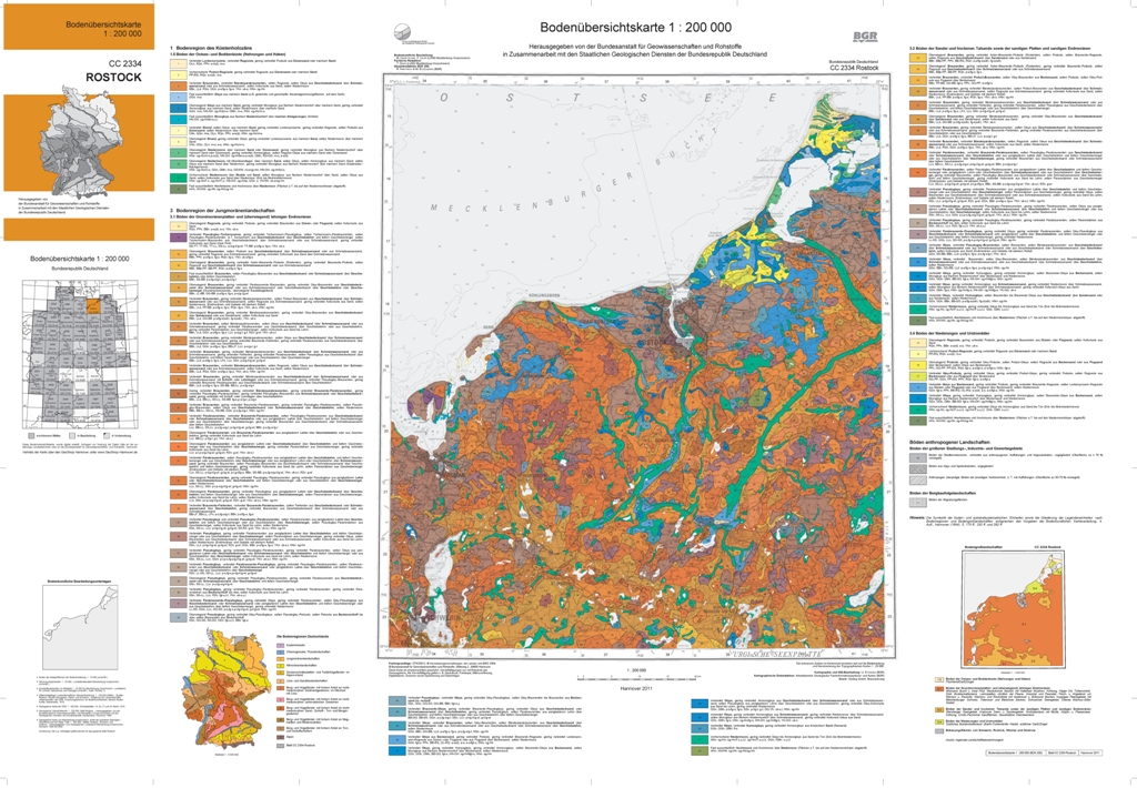
Soil Map of Germany 1:200,000 (BUEK200) - CC2334 Rostock
The soil map 1:200,000 (BUEK200) is prepared by the Federal Institute for Geosciences and Natural Resources (BGR) in cooperation with the National Geological Surveys (SGD) of the federal states in the sheet line system of the Topographic Map 1:200,000 (TUEK200) and is published in 55 individual map sheets. The digital data management provides a detailed, nationwide uniform and comprehensive information base for statements on land use and soil protection across the states. Information about the current state of processing can be found on the BGR website about soil. The soil inventories and their spatial distribution on the territory of this map sheet is described in terms of 84 legend units structured by soil regions and landscapes. Each legend unit contains soil systematic information as well as information about the soil parent material of each dominant and associated soil. Last dataset update on November 9, 2010.
|
|
Citation proposal
(2010) . Soil Map of Germany 1:200,000 (BUEK200) - CC2334 Rostock. https://gdk.gdi-de.org/geonetwork/srv/api/records/582D6580-DA89-4EE6-941C-5D639BA8A5D6 |
Simple
- Alternate title
- BÜK200 - CC2334 Rostock
- Date ( Creation )
- 2006-06-01
- Date ( Publication )
- 2010-11-09
- Date ( Revision )
- 2010-11-09
- Edition
- Version 1.1 mit Gewässerflächen
- Identifier
- 94E67256-0897-47C9-A317-775911D910AC
- Other citation details
- Größe der gedruckten Karte: 99,7 x 68,7 cm - Size of printed map: 99.7 x 68.7 cm
- Status
- completed Completed
Point of contact
Bundesanstalt für Geowissenschaften und Rohstoffe (BGR)
-
Krug, Dietmar
Stilleweg 2
Hannover
30655
DE
- GEMET - INSPIRE themes, version 1.0 ( Theme )
-
- Boden
- Soil
- GEMET - Concepts, version 2.4 ( Theme )
-
- Bodenart
- Bodenauslaugung
- Bodenbearbeitung
- Bodenbelastung
- Bodenbildung
- Bodenbiologie
- Bodenchemie
- Bodendegradation
- Bodendekontamination
- Bodenerosion
- Bodenfeuchtigkeit
- Bodenfruchtbarkeit
- Bodenfunktion
- Bodengestaltung
- Bodengüte
- Bodenkarte
- Bodenluft
- Bodenmechanik
- Bodenmineralogie
- Bodennutzbarkeit
- Bodennutzung
- SGD-Liste ( Theme )
-
- ackerbauliches Ertragspotential
- Bodeneigenschaften
- Bodengefüge
- Bodengruppe
- Bodenhorizont
- bodenphysikalische Eigenschaften
- Bodenskelett
- Bodenverbreitung
- Durchlässigkeit
- effektive Durchwurzelungstiefe
- Keywords ( Theme )
-
- Bodenausgangsgestein
- Bodenform
- Bodengesellschaft
- Bodeninformationssystem
- Bodenprofil
- Bodensubstrat
- Bodensystematik
- Bodentyp
- Fachinformationssystem
- MMK
- Keywords ( Place )
-
- Rostock
- Keywords ( Place )
-
- Mecklenburg-Vorpommern
- Keywords
-
- opendata
- Access constraints
- Other restrictions
- Use constraints
- Other restrictions
- Other constraints
- Allgemeine Geschäftsbedingungen, siehe https://www.bgr.bund.de/AGB - General terms and conditions, see https://www.bgr.bund.de/AGB_en. Die bereitgestellten Informationen sind bei Weiterverwendung wie folgt zu zitieren: Datenquelle: BÜK200 CC2334 V1.1, (C) BGR, Hannover, 2010.
- Other constraints
- Dieser Datensatz kann gemäß der "Nutzungsbestimmungen für die Bereitstellung von Geodaten des Bundes" (https://sg.geodatenzentrum.de/web_public/gdz/lizenz/geonutzv.pdf) genutzt werden.
- Other constraints
- Preis der gedruckten Karte: 14,02 EUR (zzgl. 7% MWSt. und Versandkosten) Weitere Informationen zur Bestellung beim Internationalen Landkartenhaus siehe https://www.bgr.bund.de/produktcenter-bestellhinweis-ILH
- Other constraints
- {"id": "geoNutz/20130319", "name": "Nutzungsbestimmungen für die Bereitstellung von Geodaten des Bundes", "url": "https://sg.geodatenzentrum.de/web_public/gdz/lizenz/geonutzv.pdf", "quelle": "BÜK200 CC2334 V1.1, (C) BGR, Hannover, 2010"}
- Spatial representation type
- Vector
- Denominator
- 200000
- Metadata language
- ger German
- Character set
- utf8 UTF8
- Topic category
-
- Geoscientific information
- Farming
- Environment
N
S
E
W
))
- Distribution format
-
- PDF (n/a )
- Shapefile (n/a )
- JPEG (n/a )
- PNG (n/a )
- TIFF (n/a )
- gedruckt (n/a )
- Transfer size
- 7
- OnLine resource
-
BÜK200 - CC2334 Rostock (PDF)
BÜK200 - CC2334 Rostock im Format Adobe Acrobat Datei (Auflösung 600 dpi)
- Transfer size
- 6
- OnLine resource
-
BÜK200 - CC2334 Rostock (Shapefile)
BÜK200 - CC2334 Rostock im Format ESRI Shape
- Transfer size
- 23
- OnLine resource
-
BÜK200 - CC2334 Rostock (JPEG)
BÜK200 - CC2334 Rostock im Format JPEG (Auflösung 300 dpi)
- Transfer size
- 18
- OnLine resource
-
BÜK200 - CC2334 Rostock (PNG)
BÜK200 - CC2334 Rostock im Format PNG (Auflösung 150 dpi)
- Transfer size
- 21
- OnLine resource
-
BÜK200 - CC2334 Rostock (TIFF)
BÜK200 - CC2334 Rostock im Format TIFF (Auflösung 300 dpi)
- OnLine resource
-
BÜK200 - CC2334 Rostock (gedruckt)
BÜK200 - CC2334 Rostock im Format gedruckt, gefalzt
- OnLine resource
-
BÜK200-Internetseite - BÜK200-Website
BÜK200-Internetseite - BÜK200-Website
- OnLine resource
-
Flyer zur Bodenübersichtskarte der Bundesrepublik Deutschland 1:200.000 (BÜK200) - BÜK200-Flyer
Flyer zur Bodenübersichtskarte der Bundesrepublik Deutschland 1:200.000 (BÜK200) - BÜK200-Flyer
- OnLine resource
-
Indexkarte
Indexkarte
- Hierarchy level
- Dataset
Conformance result
- Date ( Publication )
- 2010-12-08
- Explanation
- siehe dazu die angegebene Durchführungsbestimmung
- Statement
- Bodendaten und -karten 1:10.000 bis 1:200.000 von 1970-2000 (Staatlicher Geologischer Dienst des Landes Mecklenburg-Vorpommern). -
gmd:MD_Metadata
- File identifier
- 582D6580-DA89-4EE6-941C-5D639BA8A5D6 XML
- Metadata language
- German
- Character set
- utf8 UTF8
- Parent identifier
- 154997F4-3C14-4A53-B217-8A7C7509E05F
- Hierarchy level
- dataset Dataset
- Hierarchy level name
- Boden
- Date stamp
- 2020-02-14
- Metadata standard name
- INSPIRE Metadata Implementing Rules: Technical Guidelines based on EN ISO 19115 and EN ISO 19119
- Metadata standard version
- n/a
Point of contact
Overviews
Provided by

Views
582D6580-DA89-4EE6-941C-5D639BA8A5D6
Access to the portal
Read here the full details and access to the data.
Associated resources
Not available