 www.geodatenkatalog.de (S1L)
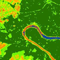
WMS SL Sentinel-2 NDVI - Sentinel-2 NDVI 2015
Sentinel-2 Normierter Differenzierter Vegetationsindex (NDVI), räumliche Auflösung 10 m (2019):Dieser Layer visualisiert den Sentinel-2 Normierter Differenzierter Vegetationsindex (NDVI) des Jahr 2015.
|
|
Citation proposal
. WMS SL Sentinel-2 NDVI - Sentinel-2 NDVI 2015. Landesamt für Vermessung, Geoinformation und Landentwicklung https://gdk.gdi-de.org/geonetwork/srv/api/records/597b8d7e-c87f-2698-d393-24fc285a5c12 |
INSPIRE
Identification
- File identifier
- 597b8d7e-c87f-2698-d393-24fc285a5c12 XML
- Hierarchy level
- service Service
Online resource
- Protocol
- OGC:WMS-1.1.1-http-get-map
Resource identifier
Encoding
Projection
Classification of data and services
Classification of data and services
- Service Type
- view
- Coupling Type
- Loose
Coupled resource
Coupled resource
Classification of data and services
- Service Type
- view
- Coupling Type
- Loose
Coupled resource
Coupled resource
Keywords
Other keywords
- Keywords
-
- 2015
- NDVI
- Sentinel-2
- Normierter Differenzierter Vegetationsindex
- Normalized Difference Vegetation Index
- infoMapAccessService
- basisdaten
Geographic coverage
N
S
E
W
))
Temporal reference
Temporal extent
Temporal extent
- Date ( Revision )
- 2025-11-13
Quality and validity
Conformity
Conformity
Conformity
Conformity
Conformity
Conformity
- Explanation
- No explanation available
- Explanation
- No explanation available
- Explanation
- No explanation available
- Explanation
- No explanation available
- Explanation
- No explanation available
- Explanation
- No explanation available
- Explanation
- No explanation available
- Explanation
- No explanation available
Restrictions on access and use
Restrictions on access and use
- Access constraints
- Die Daten sind urheberrechtlich geschützt. Der Datensatz wird entgeltfrei unter folgenden Nutzungsbedingungen zur Verfügung gestellt: <a href="https://sentinels.copernicus.eu/documents/247904/690755/Sentinel_Data_Legal_Notice">Legal notice on the use of Copernicus Sentinel Data and Service Information</a>. Der Quellenvermerk ist zu beachten. | Quellenvermerk: © Europäische Union, enthält Copernicus Sentinel-2 Daten 2021, verarbeitet durch das Landesamt für Vermessung, Geoinformation und Landentwicklung (LVGL).
Responsible organization (s)
Contact for the resource
- Organisation name
- Landesamt für Vermessung, Geoinformation und Landentwicklung
Responsible organization (s)
Contact for the resource
- Organisation name
- Landesamt für Vermessung, Geoinformation und Landentwicklung
Metadata information
Contact for the metadata
- Organisation name
- LVGL-Saarland
- gdi-sl@lvgl.saarland.de
- Date stamp
- 2025-11-13
- Metadata language
- ger German
SDS
Conformance class 1: invocable
- Pass
- true
- Pass
- true
- Pass
- true
- Pass
- true
- Pass
- true
- Pass
- true
- Pass
- true
- Pass
- true
Access Point URL
Endpoint URL
Technical specification
- Date
- Explanation
- No explanation available
- Date
- Explanation
- No explanation available
- Date
- Explanation
- No explanation available
- Date
- Explanation
- No explanation available
- Date
- Explanation
- No explanation available
- Date
- Explanation
- No explanation available
- Date
- Explanation
- No explanation available
- Date
- Explanation
- No explanation available
Conformance class 2: interoperable
Coordinate reference system
Quality of Service
Access constraints
- Access constraints
- Other restrictions
Limitation
Use constraints
Limitation
- string
- Die Daten sind urheberrechtlich geschützt. Der Datensatz wird entgeltfrei unter folgenden Nutzungsbedingungen zur Verfügung gestellt: <a href="https://sentinels.copernicus.eu/documents/247904/690755/Sentinel_Data_Legal_Notice">Legal notice on the use of Copernicus Sentinel Data and Service Information</a>. Der Quellenvermerk ist zu beachten. | Quellenvermerk: © Europäische Union, enthält Copernicus Sentinel-2 Daten 2021, verarbeitet durch das Landesamt für Vermessung, Geoinformation und Landentwicklung (LVGL).
Responsible custodian
Contact for the resource
Conformance class 3: harmonized
Contains Operations
- Operation Name
- GetCapabilities
- Distributed Computing Platforms
- Web services
Overviews
Thumbnail
Provided by

Views
597b8d7e-c87f-2698-d393-24fc285a5c12
Access to the portal
Read here the full details and access to the data.
Associated resources
Not available