 www.geodatenkatalog.de (S3F)
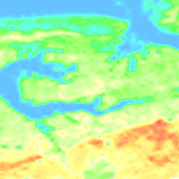
Helicopter-borne Radiometrics (HRD) Area 129 Esens
BGR conducted within the project „Airborne geophysical surveys for mapping the shallow subsurface in Germany “ (D-AERO) airborne surveys at the German North Sea coast. The survey area Esens (2008/09) ranges from about Dornum and Aurich in the west to Wittmund and Werdum in the east. The size of the area is about 370 km². The area was surveyed with 23 flights totalling to 1074 line-km (30,412 survey points). The nominal separation of the 75 N-S lines and 8 W-E tie lines was 250 m and 2000 m, respectively. The maps display the total count, the (equivalent) content of potassium, uranium and thorium as well as the exposure rate at ground.
|
|
Citation proposal
(2014) . Helicopter-borne Radiometrics (HRD) Area 129 Esens. https://gdk.gdi-de.org/geonetwork/srv/api/records/5a0a6a85-05ae-47e8-b8fd-7104c15596f2 |
INSPIRE
Identification
- File identifier
- 5a0a6a85-05ae-47e8-b8fd-7104c15596f2 XML
- Hierarchy level
- Dataset
Online resource
Resource identifier
- code
- e09a9194-66d7-4f0d-ad00-dd31b0f1a853
- Metadata language
- German
- Spatial representation type
- Grid
Encoding
- Format
- georef. TIFF
- Version
- n/a
- Format
- Version
- n/a
Projection
Classification of data and services
- Topic category
-
- Geoscientific information
Classification of data and services
Coupled resource
Coupled resource
Classification of data and services
Coupled resource
Coupled resource
Keywords
- GEMET - INSPIRE themes, version 1.0 ( Theme )
-
- Geologie
- Geology
- GEMET - Concepts, version 2.4 ( Theme )
-
- Geophysik
Other keywords
- Keywords ( Theme )
-
- Aerogeophysik
- Hubschrauber-Radiometrie
- Äquivalentgehalte
- Thorium
- Uran
- Kalium
- Ionendosisleistung
- Airborne geophysics
- helicopter-borne radiometrics
- equivalent concentrations
- Thorium
- Uranium
- Potassium
- exposure rate
- Keywords ( Place )
-
- Niedersachsen
Geographic coverage
N
S
E
W
))
Temporal reference
Temporal extent
Temporal extent
- Date ( Publication )
- 2014-01-15
Quality and validity
- Lineage
- Erarbeitung im Rahmen des BGR-Projektes "D-AERO" mit Unterstützung durch das LIAG-Projekt "Flächenhafte Befliegung mit Aerogeophysik"
Conformity
Conformity
Conformity
Conformity
Conformity
Conformity
- Explanation
- siehe dazu die angegebene Durchführungsbestimmung
Restrictions on access and use
- Access constraints
- Allgemeine Geschäftsbedingungen, siehe https://www.bgr.bund.de/AGB - General terms and conditions, see https://www.bgr.bund.de/AGB_en. Die bereitgestellten Informationen sind bei Weiterverwendung wie folgt zu zitieren: Datenquelle: 129EsensHRD, (c) BGR, Hannover, 2016, doi:10.25928/bgr129hrd_2jr3-9896
Restrictions on access and use
Responsible organization (s)
Contact for the resource
- Organisation name
- Bundesanstalt für Geowissenschaften und Rohstoffe (BGR)
- heli@bgr.de
Responsible organization (s)
Contact for the resource
- Organisation name
- Bundesanstalt für Geowissenschaften und Rohstoffe (BGR)
- heli@bgr.de
Metadata information
Contact for the metadata
- Organisation name
- Bundesanstalt für Geowissenschaften und Rohstoffe (BGR)
- Date stamp
- 2021-07-06
- Metadata language
- German
- Character set
- UTF8
SDS
Conformance class 1: invocable
Access Point URL
Endpoint URL
Technical specification
Conformance class 2: interoperable
Coordinate reference system
Quality of Service
Access constraints
Limitation
Use constraints
Limitation
Responsible custodian
Contact for the resource
Conformance class 3: harmonized
Overviews
Provided by

Views
5a0a6a85-05ae-47e8-b8fd-7104c15596f2
Access to the portal
Read here the full details and access to the data.
Associated resources
Not available