 My GeoNetwork catalogue
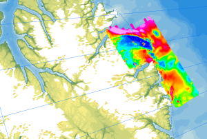
Helicopter-borne Magnetics CASE11
Onshore geological field work combined with an onshore/offshore aeromagnetic survey was carried out during a joint expedition of the German BGR and the Canadian GSC to understand the structural architecture of the North American continental margin. The helicopter-borne magnetic survey of 2008 covered the northern coastal areas of Ellesmere Island and the adjacent marine areas. The survey was conducted with a line separation of 2 km and covered a 40 to 50 km wide swath offshore about parallel to the north coast of Ellesmere Island from Yelverton Bay in the west to Parr Bay east of Cape Columbia, the northernmost point of Canada. Between Yelverton Bay and M'Clintock Inlet, the survey extended about 40 to 50 km inland, which was the prime target area of the CASE 11 geological investigations. This section of mountainous terrain was flown in a “draped” mode to keep the distance to ground at approximately 1500 ft, same as over the offshore areas. During a 4-weeks period in May/June 2008, close to 8000 km of aeromagnetic line data were acquired, covering an area of 12000 km².
- Identification
- Distribution
- Quality
- Spatial rep.
- Ref. system
- Content
- Portrayal
- Metadata
- Md. constraints
- Md. maintenance
- Schema info
Identification
Data identification
Citation
- Alternate title
-
AeromagCASE11
- Date (Publication)
- 2023-02-22
- Citation identifier
- afb3116e-5c1b-4f53-a7a2-495aab80faf7
- Status
- Completed
-
GEMET - INSPIRE themes, version 1.0
-
-
Geologie
-
Geology
-
-
GEMET - Concepts, version 2.4
-
-
Geophysik
-
- Theme
-
-
Aerogeophysik
-
Aeromagnetik
-
Anomalien des erdmagnetischen Feldes
-
Airborne geophysics
-
helicopter-borne /fixed-wing magnetics
-
anomalies of the Earth’s magnetic field
-
- Place
-
-
Arktis
-
Arctic
-
Nordpolargebiet
-
North Polar
-
Ellesmere Island
-
Legal constraints
- Access constraints
- Other restrictions
- Other constraints
- Es gelten keine Zugriffsbeschränkungen
Legal constraints
- Use constraints
- Other restrictions
- Other constraints
-
Allgemeine Geschäftsbedingungen, siehe https://www.bgr.bund.de/AGB - General terms and conditions, see https://www.bgr.bund.de/AGB_en . Die bereitgestellten Informationen sind bei Weiterverwendung wie folgt zu zitieren: Datenquelle: AeromagCASE11, (c) BGR, Hannover, 2023
- Language
- English
- Character set
- UTF8
- Topic category
-
- Geoscientific information
))
Distribution
Distribution
- Distribution format
-
-
GeoTIFF
(
n/a
)
-
shp
(
n/a
)
-
WMS
(
OGC:WMS1.3.0
)
-
GeoTIFF
(
n/a
)
- OnLine resource
-
AeromagCASE11 (GeoTIFF)
AeromagCASE11 im Format geoTiff
- OnLine resource
- Arktisforschung der BGR
- OnLine resource
- Karte im BGR-Geoviewer
- OnLine resource
-
Flightlines (Shape)
Flightlines im Format Shape
Quality
Data quality
Scope
- Hierarchy level
- Dataset
- Statement
-
The aeromagnetic data were jointly collected by GSC Canada and BGR as part of the CASE program during the CASE 11 expedition on Ellesmere Island.
Ref. system
- Unique resource identifier
- EPSG:3995
Metadata
Metadata
- File identifier
- 5aa4488e-f0cc-4edd-bedf-a2b9256c8107 XML
- Metadata language
- English
- Character set
- UTF8
- Parent identifier
-
Helicopter-borne Magnetics in the Arctic region
e85d6dcc-91b8-48bc-a80d-7ca0f9546cda
- Hierarchy level
- Dataset
- Hierarchy level name
-
Geophysik
- Date stamp
- 2026-01-13
- Metadata standard name
-
INSPIRE Metadata Implementing Rules: Technical Guidelines based on EN ISO 19115 and EN ISO 19119
- Metadata standard version
-
n/a
Overviews
Spatial extent
Provided by
