 www.geodatenkatalog.de (S3L)
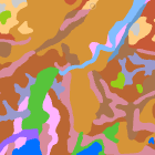
Bodenübersichtskarte 1:200.000 Bayern - WMS
Die Bodenübersichtskarte von Bayern 1:200.000 (BÜK200-BY) entstand durch Zusammenführung der bundesweit in Einzelblattschnitten vorliegenden und über die BGR erhältlichen Bodenübersichtskarte der Bundesrepublik Deutschland (BÜK200).
Für den Gesamtumgriff Bayerns wurden die Einzelblätter der BÜK200 zusammengefügt, Blattgrenzen aufgelöst, einzelne Flächen nochmals überarbeitet und die Inhalte der jeweiligen Kartenlegenden zusammengeführt, überarbeitet und gestrafft. Die BÜK200-BY liegt flächendeckend und blattschnittfrei vor, mit einer bayernspezifischen Generallegende.
Inhaltliche Differenzen zu den Einzelblättern der BÜK200 sind gering und in der Regel aufgrund des regionalen Ansatzes gewollt.
Die BÜK200 beruht auf der Aggregierung und Generalisierung der ebenfalls flächendeckend vorliegenden Übersichtsbodenkarte 1:25.000 (ÜBK25). Ein Datensatz an Referenzprofilen für die einzelnen Legendeneinheiten liegt vor.
|
|
Citation proposal
. Bodenübersichtskarte 1:200.000 Bayern - WMS. https://gdk.gdi-de.org/geonetwork/srv/api/records/5d87e523-efdd-452a-841c-8c9467d808bb |
INSPIRE
Identification
- File identifier
- 5d87e523-efdd-452a-841c-8c9467d808bb XML
- Hierarchy level
- service Service
Online resource
Resource identifier
Encoding
- Format
- Sonstiges
Projection
Classification of data and services
Classification of data and services
- Service Type
- view
- Coupling Type
- Tight
Coupled resource
Coupled resource
Classification of data and services
- Service Type
- view
- Coupling Type
- Tight
Coupled resource
Coupled resource
Keywords
- Service Classification, version 1.0 ( Theme )
-
- infoMapAccessService
Other keywords
- Keywords
-
- gdiby
- Bodenkarte
- Boden
Geographic coverage
))
Temporal reference
Temporal extent
Temporal extent
- Date ( Creation )
- 2020-11-25T00:00:00.000+01:00
Quality and validity
Conformity
Conformity
Conformity
Conformity
Conformity
Conformity
Restrictions on access and use
Restrictions on access and use
- Access constraints
- Creative Commons Namensnennung 4.0 International (CC BY 4.0); Datenquelle: Bayerisches Landesamt für Umwelt, www.lfu.bayern.de
- Access constraints
- {"id":"cc-by/4.0","name":"Creative Commons Namensnennung 4.0 International (CC BY 4.0)","url":"https://creativecommons.org/licenses/by/4.0/deed.de","quelle":"Bayerisches Landesamt für Umwelt, www.lfu.bayern.de"}
Responsible organization (s)
Contact for the resource
- Organisation name
- Bayerisches Landesamt für Umwelt
Responsible organization (s)
Contact for the resource
- Organisation name
- Bayerisches Landesamt für Umwelt
Metadata information
Contact for the metadata
- Organisation name
- Bayerisches Landesamt für Umwelt
- Date stamp
- 2025-08-13
- Metadata language
- German
SDS
Conformance class 1: invocable
Access Point URL
Endpoint URL
Technical specification
Conformance class 2: interoperable
Coordinate reference system
Quality of Service
Access constraints
- Access constraints
- otherRestrictions Other restrictions
Limitation
Use constraints
Limitation
- string
- Creative Commons Namensnennung 4.0 International (CC BY 4.0); Datenquelle: Bayerisches Landesamt für Umwelt, www.lfu.bayern.de
- string
- {"id":"cc-by/4.0","name":"Creative Commons Namensnennung 4.0 International (CC BY 4.0)","url":"https://creativecommons.org/licenses/by/4.0/deed.de","quelle":"Bayerisches Landesamt für Umwelt, www.lfu.bayern.de"}
Responsible custodian
Contact for the resource
Conformance class 3: harmonized
Contains Operations
- Operation Name
- GetCapabilities
- Distributed Computing Platforms
- Web services
- Operation Description
- application/vnd.ogc.wms_xml; text/xml;
- Connect Point
- https://www.lfu.bayern.de/gdi/wms/boden/buek200by?
Contains Operations
- Operation Name
- GetMap
- Distributed Computing Platforms
- Web services
- Operation Description
- image/bmp; image/jpeg; image/tiff; image/png; image/png8; image/png24; image/png32; image/gif; image/svg+xml;
- Connect Point
- https://www.lfu.bayern.de/gdi/wms/boden/buek200by?
Contains Operations
- Operation Name
- GetFeatureInfo
- Distributed Computing Platforms
- Web services
- Operation Description
- application/vnd.esri.wms_raw_xml; application/vnd.esri.wms_featureinfo_xml; application/vnd.ogc.wms_xml; application/geojson; text/xml; text/html; text/plain;
- Connect Point
- https://www.lfu.bayern.de/gdi/wms/boden/buek200by?
Contains Operations
- Operation Name
- esri_wms:GetStyles
- Distributed Computing Platforms
- Web services
- Operation Description
- application/vnd.ogc.sld+xml;
- Connect Point
- https://www.lfu.bayern.de/gdi/wms/boden/buek200by?
Overviews
Provided by
