 www.geodatenkatalog.de (S2L)
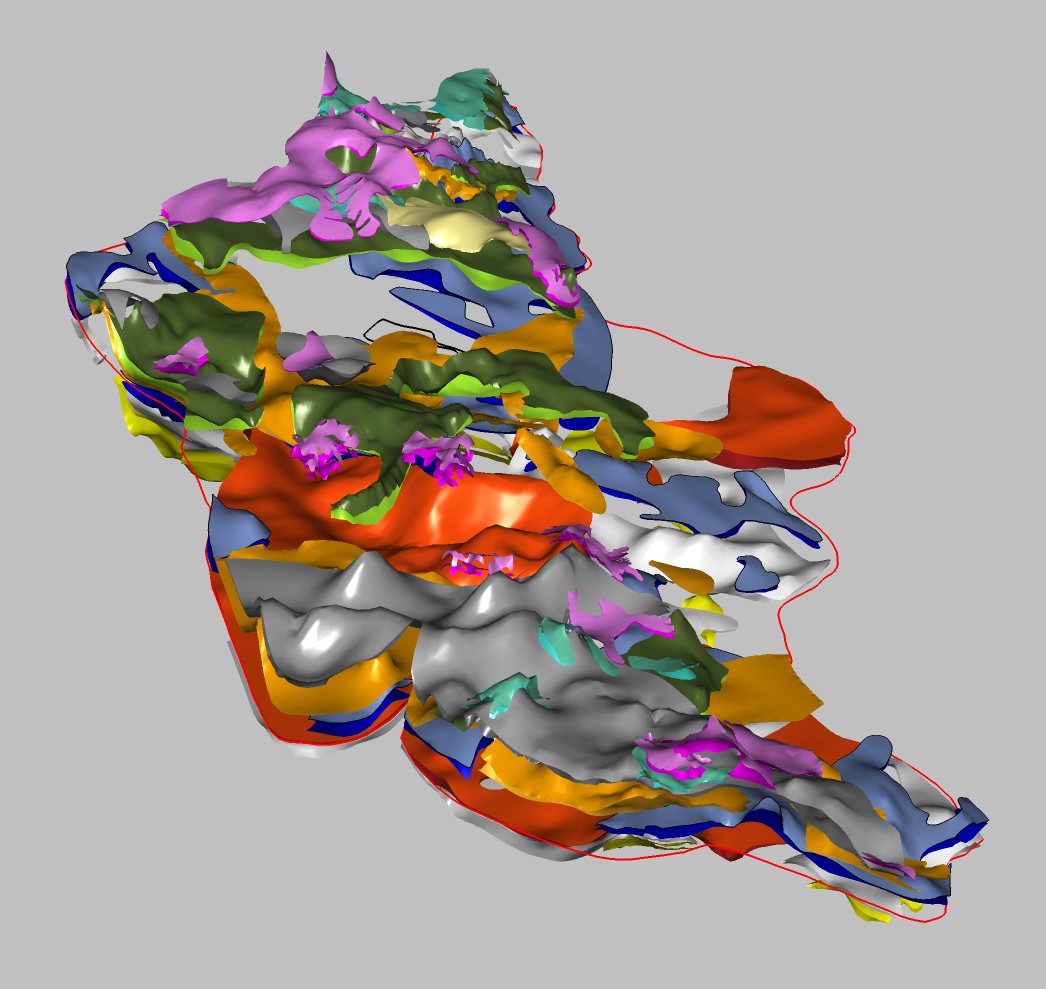
Structural model of the quarternary in the sub-catchment "Mittlere Oder"
The project Geo3D-Oder aims at establishing geological 3D models of three sub-catchment areas along the Oder river in the federal state of Brandenburg in the north of the confluence of the Neisse river. The combined model of the sub-catchments shall serve as a basis for a quantitative groundwater model. In this context the model shows the aquitardes formed by the cohesive sediments of ground moraines, glaciolacustrine deposits and sediments of the Holstein interglacial period up to the till of the younger Elsterian ice age as the lowest horizon. For the time being any other space is interpreted undifferentiated as an aquifer. The respective data basis comes from the “Lithofazieskarte Quartär (LKQ 50)” of the former GDR at a scale of 1 : 50,000. The structural model of the sub-catchment area „Mittlere Oder“ constitutes the first model section. It consists of the ground surface derived from the Digital Terrain Model DGM 50 and ten horizons confined by top and base layers. As a simplification, the model assumes a concordant sequence of horizons without any faults. Due to data gaps for several horizons just a hypothetical modelling is feasible in relevant parts applying a specifically developed methodology. For this purpose, auxiliary horizons (“virtual horizons”) are built based on the elevation of other horizons in order to serve as modeling constraints. The resulting horizons were finished using several tools provided by the modeling software SKUA-GOCAD.
|
|
Citation proposal
(2022) . Structural model of the quarternary in the sub-catchment "Mittlere Oder". https://gdk.gdi-de.org/geonetwork/srv/api/records/5d980350-24a7-4c27-affb-2fbfbdccf251 |
INSPIRE
Identification
- File identifier
- 5d980350-24a7-4c27-affb-2fbfbdccf251 XML
- Hierarchy level
- Dataset
Online resource
Resource identifier
- code
- 5489ee61-f748-83e3-4be9-5a430b85b389
- Metadata language
- German
- Spatial representation type
- TIN
Encoding
- Format
- online
- Version
- n/a
- Format
- GOCAD/SKUA
- Version
- n/a
Projection
Classification of data and services
- Topic category
-
- Geoscientific information
Classification of data and services
Coupled resource
Coupled resource
Classification of data and services
Coupled resource
Coupled resource
Keywords
- GEMET - INSPIRE themes, version 1.0 ( Theme )
-
- Geologie
- Geology
Other keywords
- Keywords ( Theme )
-
- Geologisches Strukturmodell
- 3D-Modell
- Hydrogeologie
- Quartär
- Grundwasserhemmer
- Strukturgeologie
- Keywords ( Place )
-
- Brandenburg
- Mittlere Oder
Geographic coverage
N
S
E
W
))
Temporal reference
Temporal extent
Temporal extent
- Date ( Publication )
- 2022-08-17
Quality and validity
- Lineage
- 3D-Modellierung mittels SKUA-GOCAD auf Grundlage von Daten aus einer Digitalisierung der Lithofazieskarte Quartär im Maßstab 1 : 50.000 (LKQ 50)
Conformity
Conformity
Conformity
Conformity
Conformity
Conformity
- Explanation
- siehe dazu die angegebene Durchführungsbestimmung
Restrictions on access and use
- Access constraints
- Allgemeine Geschäftsbedingungen, siehe https://www.bgr.bund.de/AGB General terms and conditions, see https://www.bgr.bund.de/AGB_en. Die bereitgestellten Informationen sind bei Weiterverwendung wie folgt zu zitieren: Datenquelle: Geo3D-Oder MO, (c) BGR, Hannover, 2022
Restrictions on access and use
Responsible organization (s)
Contact for the resource
- Organisation name
- Bundesanstalt für Geowissenschaften und Rohstoffe (BGR)
- Klaus.Duscher@bgr.de
Responsible organization (s)
Contact for the resource
- Organisation name
- Bundesanstalt für Geowissenschaften und Rohstoffe (BGR)
- Klaus.Duscher@bgr.de
Metadata information
Contact for the metadata
- Organisation name
- Bundesanstalt für Geowissenschaften und Rohstoffe (BGR)
- Date stamp
- 2025-04-07
- Metadata language
- German
- Character set
- UTF8
SDS
Conformance class 1: invocable
Access Point URL
Endpoint URL
Technical specification
Conformance class 2: interoperable
Coordinate reference system
Quality of Service
Access constraints
Limitation
Use constraints
Limitation
Responsible custodian
Contact for the resource
Conformance class 3: harmonized
Overviews
Provided by

Views
5d980350-24a7-4c27-affb-2fbfbdccf251
Access to the portal
Read here the full details and access to the data.
Associated resources
Not available