 www.geodatenkatalog.de (S3L)
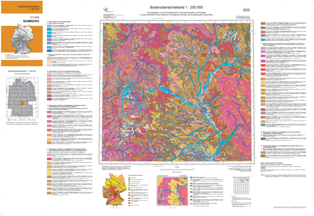
Soil Map of Germany 1:200,000 (BUEK200) - CC6326 Bamberg
The soil map 1:200,000 (BUEK200) is prepared by the Federal Institute for Geosciences and Natural Resources (BGR) in cooperation with the National Geological Surveys (SGD) of the federal states in the sheet line system of the Topographic Map 1:200,000 (TUEK200) and is published in 55 individual map sheets. The digital data management provides a detailed, nationwide uniform and comprehensive information base for statements on land use and soil protection across the states. Information about the current state of processing can be found on the BGR website about soil. The soil inventories and their spatial distribution on the territory of this map sheet is described in terms of 67 legend units structured by soil regions and landscapes. Each legend unit contains soil systematic information as well as information about the soil parent material of each dominant and associated soil.
|
|
Citation proposal
(2017) . Soil Map of Germany 1:200,000 (BUEK200) - CC6326 Bamberg. https://gdk.gdi-de.org/geonetwork/srv/api/records/5dff4e77-6592-4fc0-86f8-009088decaa0 |
INSPIRE
Identification
- File identifier
- 5dff4e77-6592-4fc0-86f8-009088decaa0 XML
- Hierarchy level
- dataset Dataset
Online resource
Resource identifier
- code
- 89353840-7768-11e7-b62d-8851fb422c62
- Metadata language
- ger German
- Spatial representation type
- Vector
Encoding
- Format
- Version
- n/a
- Format
- Shapefile
- Version
- n/a
- Format
- JPEG
- Version
- n/a
- Format
- PNG
- Version
- n/a
- Format
- TIFF
- Version
- n/a
- Format
- gedruckt
- Version
- n/a
Projection
Classification of data and services
- Topic category
-
- Geoscientific information
- Farming
- Environment
Classification of data and services
Coupled resource
Coupled resource
Classification of data and services
Coupled resource
Coupled resource
Keywords
- GEMET - INSPIRE themes, version 1.0 ( Theme )
-
- Boden
- Soil
- GEMET - Concepts, version 2.4 ( Theme )
-
- Bodenbearbeitung
- Bodenerosion
- Bodenfeuchtigkeit
- Bodenart
- Bodenmineralogie
- Bodengestaltung
- Bodenkarte
- Bodenfunktion
- Bodenbelastung
- Bodendegradation
- Bodenfruchtbarkeit
- Bodenauslaugung
- Bodennutzung
- Bodennutzbarkeit
- Bodenbildung
- Bodenmechanik
- Bodendekontamination
- Bodenchemie
- Bodenbiologie
- Bodenluft
- Bodengüte
- SGD-Liste ( Theme )
-
- Bodengruppe
- Bodengefüge
- Bodenskelett
- Bodenverbreitung
- Bodenhorizont
- bodenphysikalische Eigenschaften
- effektive Durchwurzelungstiefe
- Durchlässigkeit
- Bodeneigenschaften
Other keywords
- Keywords ( Theme )
-
- Bodengesellschaft
- Bodensubstrat
- Bodenprofil
- Bodentyp
- Bodenform
- Bodensystematik
- Bodeninformationssystem
- Bodenausgangsgestein
- Bodengesellschaft
- Fachinformationssystem
- Keywords ( Place )
-
- Bamberg
- Bayern
- Thüringen
- Keywords
-
- opendata
Geographic coverage
N
S
E
W
))
Temporal reference
Temporal extent
Temporal extent
- Date ( Creation )
- 2017-03-01
- Date ( Publication )
- 2017-06-20
Quality and validity
- Lineage
- Bodendaten und -karten 1:10.000 bis 1:25.000 (Staatliche Geologische Dienste der Länder Bayern und Thüringen).
- Denominator
- 200000
Conformity
Conformity
Conformity
Conformity
Conformity
Conformity
- Explanation
- siehe dazu die angegebene Durchführungsbestimmung
Restrictions on access and use
- Access constraints
- Allgemeine Geschäftsbedingungen, siehe http://www.bgr.bund.de/AGB - General terms and conditions, see http://www.bgr.bund.de/AGB_en. Die bereitgestellten Informationen sind bei Weiterverwendung wie folgt zu zitieren: Datenquelle: BÜK200 CC6326 V1.0, (C) BGR, Hannover, 2017.
- Access constraints
- Dieser Datensatz kann gemäß der "Nutzungsbestimmungen für die Bereitstellung von Geodaten des Bundes" (https://sg.geodatenzentrum.de/web_public/gdz/lizenz/geonutzv.pdf) genutzt werden.
- Access constraints
- Preis der gedruckten Karte: 14,02 EUR (zzgl. 7% MWSt. und Versandkosten) Weitere Informationen zur Bestellung beim Internationalen Landkartenhaus siehe https://www.bgr.bund.de/produktcenter-bestellhinweis-ILH
- Access constraints
- {"id": "geoNutz/20130319", "name": "Nutzungsbestimmungen für die Bereitstellung von Geodaten des Bundes", "url": "https://sg.geodatenzentrum.de/web_public/gdz/lizenz/geonutzv.pdf", "quelle": "BÜK200 CC6326 V1.0, (C) BGR, Hannover, 2017"}
Restrictions on access and use
Responsible organization (s)
Contact for the resource
- Organisation name
- Bundesanstalt für Geowissenschaften und Rohstoffe (BGR)
- fis.bo@bgr.de
Responsible organization (s)
Contact for the resource
- Organisation name
- Bundesanstalt für Geowissenschaften und Rohstoffe (BGR)
- fis.bo@bgr.de
Metadata information
Contact for the metadata
- Organisation name
- Bundesanstalt für Geowissenschaften und Rohstoffe (BGR)
- Date stamp
- 2020-02-11
- Metadata language
- German
- Character set
- utf8 UTF8
SDS
Conformance class 1: invocable
Access Point URL
Endpoint URL
Technical specification
Conformance class 2: interoperable
Coordinate reference system
Quality of Service
Access constraints
Limitation
Use constraints
Limitation
Responsible custodian
Contact for the resource
Conformance class 3: harmonized
Overviews
Provided by

Views
5dff4e77-6592-4fc0-86f8-009088decaa0
Access to the portal
Read here the full details and access to the data.
Associated resources
Not available