 My GeoNetwork catalogue
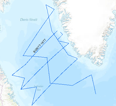
Processed seismic data of Cruise BGR 1977
A geophysical reconnaissance survey was carried out in the Labrador Sea and Davis Strait between July and September 1977 by BGR. The data format is Society of Exploration Geophysicists SEG Y. The survey was executed on the research vessel MS Explora. The seismic, magnetic and gravity data from 5931 line-kilometers on 21 lines were recorded on magnetic tape. A 24-fold coverage technique was used with 48 seismic channels (traces), with a 2400m streamer cable, and 23.45 l airgun array. A full integrated computerized satellite navigation system (INDAS III) served as positioning system. Based on a preliminary interpretation of the seismograms, the Labrador Sea was devided into an eastern (Greenland) and western (Canadian) area, seperated by the Mid Labrador Ridge. Within the eastern part of the Labrador Sea the Pre-Cenozoic sediments show three distinct layers, traceable over the entire Greenland area of the sea. In the Cenozoic layer olisthostromes occur. The highest apparent velocity determined from sonobuoy data was 9.26 km/sec. The calculated refractor lies at a depth of approximately 13 km. The seismic section from the sediments on the Canadian side of the Labrador Sea show a uniform series of thick sediments below the Cenozoic cover. The highly disturbed basement is often masked by the multiple reflections from the seafloor. Statements about the nature and structure of the basement can only be made after processing data.
Simple
- Alternate title
-
BGR77 1977
- Date (Creation)
- 1977-09-08
- Citation identifier
- 66989e10-f8de-44bc-93cb-4871dc1e2ba4
- Status
- Completed
-
GEMET - INSPIRE themes, version 1.0
-
-
geology
-
Geologie
-
-
GEMET - Concepts, version 2.4
-
-
geophysics
-
Geophysik
-
raw material
-
Rohstoff
-
marine geology
-
Meeresgeologie
-
- Theme
-
-
seismics
-
Seismik
-
two-dimensional seismic reflection
-
zweidimensionale Reflektionsseismik
-
MSSP
-
- Place
-
-
Labrador Sea
-
Labrador See
-
- Access constraints
- Other restrictions
- Other constraints
- Es gelten keine Zugriffsbeschränkungen
- Use constraints
- Other restrictions
- Other constraints
-
Allgemeine Geschäftsbedingungen, siehe https://www.bgr.bund.de/AGB - General terms and conditions, see https://www.bgr.bund.de/AGB_en . Die bereitgestellten Informationen sind bei Weiterverwendung wie folgt zu zitieren: Datenquelle: BGR77, (c) BGR, Hannover, 1977
- Spatial representation type
- Vector
- Language
- English
- Character set
- UTF8
- Topic category
-
- Geoscientific information
))
- Unique resource identifier
- EPSG:4326
- Distribution format
-
-
Shapefile
(
n/a
)
-
Shapefile
(
n/a
)
- Transfer size
- 1
- OnLine resource
-
BGR77 1977 (Shapefile)
BGR77 1977 im Format ESRI Shape
- OnLine resource
- Profil BGR77-01
- OnLine resource
- Profil BGR77-02
- OnLine resource
- Profil BGR77-03a
- OnLine resource
- Profil BGR77-04
- OnLine resource
- Profil BGR77-05
- OnLine resource
- Profil BGR77-06
- OnLine resource
- Profil BGR77-07
- OnLine resource
- Profil BGR77-08
- OnLine resource
- Profil BGR77-09
- OnLine resource
- Profil BGR77-10
- OnLine resource
- Profil BGR77-11
- OnLine resource
- Profil BGR77-12
- OnLine resource
- Profil BGR77-13
- OnLine resource
- Profil BGR77-14
- OnLine resource
- Profil BGR77-15
- OnLine resource
- Profil BGR77-16
- OnLine resource
- Profil BGR77-17
- OnLine resource
- Profil BGR77-17a
- OnLine resource
- Profil BGR77-18
- OnLine resource
- Profil BGR77-19
- OnLine resource
- Profil BGR77-19a
- OnLine resource
- Profil BGR77-20
- OnLine resource
- Profil BGR77-21
- OnLine resource
- Profil BGR77-21a
- OnLine resource
- Karte im BGR-Geoviewer
- Hierarchy level
- Dataset
Conformance result
- Date (Publication)
- 2010-12-08
- Explanation
-
siehe dazu die angegebene Durchführungsbestimmung
- Statement
-
During the period between 18th of July to 8th of September 1977 BGR aquired seismic lines in the Labrador Sea and the Davis Strait. The lines BGR77-01, BGR77-02, BGR77-04, BGR77-05, BGR77-06, BGR77-07, BGR77-08, BGR77-09, BGR77-10, BGR77-12, BGR77-17, BGR77-17A, BGR77-18, BGR77-19, BGR77-19A, BGR77-20, BGR77-21A are processed (migrated) data. The lines BGR77-03A, BGR77-11, BGR77-14, BGR77-15, BGR77-16 and BGR77-21 are raw data.
- File identifier
- 5feebc6e-6030-410b-8aa8-aac6ee311e52 XML
- Metadata language
- English
- Character set
- UTF8
- Parent identifier
-
Marine Seismic Survey Profiles (MSSP)
06a73c56-06a2-40d8-b806-466222b0760d
- Hierarchy level
- Dataset
- Hierarchy level name
-
Geophysik
- Date stamp
- 2025-04-07
- Metadata standard name
-
INSPIRE Metadata Implementing Rules: Technical Guidelines based on EN ISO 19115 and EN ISO 19119
- Metadata standard version
-
n/a
Overviews
Spatial extent
Provided by
