 www.geodatenkatalog.de (S3L)
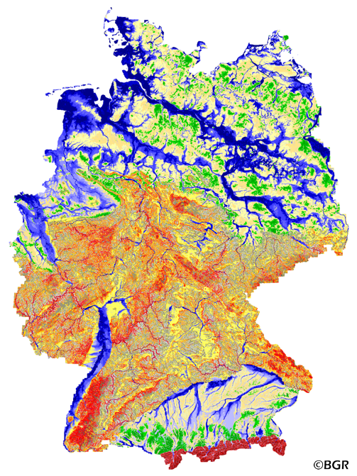
Geomorphographic Map of Germany
The relief of the earth's surface is a major controlling factor for ecological processes and a key indicator of the distribution patterns of important geological factors such as soil, rock and water. On the basis of a digital elevation model with a grid size of 250 meters, the company scilands GmbH in Göttingen produced on behalf of BGR the geomorphographic map of Germany. The programs SARA (System for Automatic Terrain Analysis) and SADO (System for Analysis and Discretization of Surfaces) determined 25 discrete geomorphograpic units (sink areas, closed hollow forms, slope areas, parietal areas, overlay forms) in four different landscape areas (North German Lowland, highland, Alpine foothills and Alps).
|
|
Citation proposal
(2014) . Geomorphographic Map of Germany. https://gdk.gdi-de.org/geonetwork/srv/api/records/60ab5e4e-9493-44b0-9cae-d9ce603de742 |
INSPIRE
Identification
- File identifier
- 60ab5e4e-9493-44b0-9cae-d9ce603de742 XML
- Hierarchy level
- Dataset
Online resource
Resource identifier
- code
- 1b87ebc3-ac85-47da-b83b-424f97aa95d4
- Metadata language
- German
- Spatial representation type
- Grid
Encoding
- Format
- Version
- n/a
- Format
- georef. TIFF
- Version
- n/a
Projection
Classification of data and services
- Topic category
-
- Geoscientific information
Classification of data and services
Coupled resource
Coupled resource
Classification of data and services
Coupled resource
Coupled resource
Keywords
- GEMET - INSPIRE themes, version 1.0 ( Theme )
-
- Biogeografische Regionen
- Geologie
- Höhe
- GEMET - Concepts, version 2.4 ( Theme )
-
- Geomorphologie
- Freies Schlagwort ( Theme )
-
- Relief
- Digitale Reliefanalyse
- Digitales Geländemodell
- Morphometrische Reliefparameter
- Geomorphographische Einheiten
- Senkenbereiche
- Hangbereiche
- Scheitelbereiche
Other keywords
- Keywords ( Place )
-
- Bundesrepublik Deutschland
Geographic coverage
N
S
E
W
))
Temporal reference
Temporal extent
Temporal extent
- Date ( Creation )
- 2006-07-17
- Date ( Publication )
- 2014-07-14
Quality and validity
- Lineage
- Korrigiertes DGM-D (50 Meter Rasterweite) des Bundesamtes für Kartographie und Geodäsie (BKG).
- Denominator
- 1000000
Conformity
Conformity
Conformity
Conformity
Conformity
Conformity
- Explanation
- siehe dazu die angegebene Durchführungsbestimmung
Restrictions on access and use
- Access constraints
- Allgemeine Geschäftsbedingungen, siehe https://www.bgr.bund.de/AGB - General terms and conditions, see https://www.bgr.bund.de/AGB_en. Die bereitgestellten Informationen sind bei Weiterverwendung wie folgt zu zitieren: Datenquelle: GMK1000R V2.0, (C) BGR, Hannover, 2006.
Restrictions on access and use
Responsible organization (s)
Contact for the resource
- Organisation name
- Bundesanstalt für Geowissenschaften und Rohstoffe (BGR)
- fis.bo@bgr.de
Responsible organization (s)
Contact for the resource
- Organisation name
- Bundesanstalt für Geowissenschaften und Rohstoffe (BGR)
- fis.bo@bgr.de
Metadata information
Contact for the metadata
- Organisation name
- Bundesanstalt für Geowissenschaften und Rohstoffe (BGR)
- Date stamp
- 2023-08-22
- Metadata language
- German
- Character set
- UTF8
SDS
Conformance class 1: invocable
Access Point URL
Endpoint URL
Technical specification
Conformance class 2: interoperable
Coordinate reference system
Quality of Service
Access constraints
Limitation
Use constraints
Limitation
Responsible custodian
Contact for the resource
Conformance class 3: harmonized
Overviews
Provided by

Views
60ab5e4e-9493-44b0-9cae-d9ce603de742
Access to the portal
Read here the full details and access to the data.
Associated resources
Not available