 www.geodatenkatalog.de (S3L)
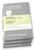
RK 50 LG A - Rohstoffkarte von Nordrhein-Westfalen 1:50.000 (Lockergestein) - analog
Das Kartenwerk zeigt Vorkommen nichtenergetischer oberflächennaher Rohstoffe Nordrhein-Westfalens. Die Kartenblätter liegen gescannt und georeferenziert vor. Verfügbare Themen zu den drei Lockergesteins-Rohstoffgruppen Kies/Kiessand, Sand, Ton/Schluff: Verbreitung und Mächtigkeit des Rohstoffkörpers (Blatt 1), Mächtigkeit der Überlagerung (Blatt 2), Vorkommen von Zwischenmitteln (Anzahl, Mächtigkeit und Tiefenlage von Einlagerungen im Rohstoffkörper) sowie Basis des Rohstoffkörpers (Blatt 3).
|
|
Citation proposal
(2018) . RK 50 LG A - Rohstoffkarte von Nordrhein-Westfalen 1:50.000 (Lockergestein) - analog. https://gdk.gdi-de.org/geonetwork/srv/api/records/6196CDAB-6E51-4DB9-A178-33EAB161849B |
INSPIRE
Identification
- File identifier
- 6196CDAB-6E51-4DB9-A178-33EAB161849B XML
- Hierarchy level
- series Dataset
Online resource
Resource identifier
- Metadata language
- German
- Spatial representation type
- Grid
Encoding
- Format
- JPEG
- Version
- -
Projection
Classification of data and services
- Topic category
-
- Geoscientific information
Classification of data and services
Coupled resource
Coupled resource
Classification of data and services
Coupled resource
Coupled resource
Keywords
- UMTHES Thesaurus ( Theme )
-
- Lagerstätte
- Sand
- Kies
- Lockergestein
- Ton
- OGDD-Kategorien
-
- geo
Other keywords
- Keywords
-
- Rohstoffkarte
- Mineralische Bodenschätze
- Rohstoffkörper
- Mächtigkeit
- Kiesabbau
- ISRK50
- opendata
Geographic coverage
N
S
E
W
))
Temporal reference
Temporal extent
Temporal extent
- Date ( Revision )
- 2016-11-09
- Date ( Publication )
- 2018-08-17
Quality and validity
- Lineage
- Integrierte Geowissenschaftliche Landesaufnahme (IGL) des Landes NRW
- Denominator
- 50000
Conformity
Conformity
Conformity
Conformity
Conformity
Conformity
Restrictions on access and use
- Access constraints
- Farbplot kostenpflichtig
- Access constraints
- {"id": "dl-by-de/2.0","name": "Datenlizenz Deutschland Namensnennung 2.0","url": "https://www.govdata.de/dl-de/by-2-0","quelle": "RK 50 LG A @ Geologischer Dienst NRW, (<Jahr des Datenbezugs>)"}
Restrictions on access and use
Responsible organization (s)
Contact for the resource
- Organisation name
- Geologischer Dienst NRW
- geodaten@gd.nrw.de
Responsible organization (s)
Contact for the resource
- Organisation name
- Geologischer Dienst NRW
- geodaten@gd.nrw.de
Metadata information
Contact for the metadata
- Organisation name
- Geologischer Dienst NRW
- metadaten@gd.nrw.de
- Date stamp
- 2024-12-05
- Metadata language
- ger German
- Character set
- UTF8
SDS
Conformance class 1: invocable
Access Point URL
Endpoint URL
Technical specification
Conformance class 2: interoperable
Coordinate reference system
Quality of Service
Access constraints
Limitation
Use constraints
Limitation
Responsible custodian
Contact for the resource
Conformance class 3: harmonized
Overviews
Rohstoffkarte, gefaltet
Provided by

Views
6196CDAB-6E51-4DB9-A178-33EAB161849B
Access to the portal
Read here the full details and access to the data.
Associated resources
Not available