 My GeoNetwork catalogue
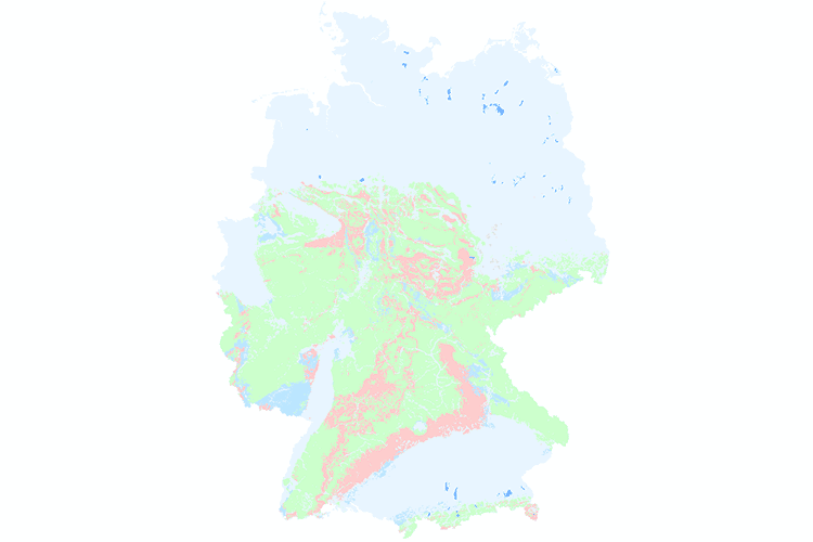
Hydrogeological Map of Germany 1:250,000 (HÜK250)
In order to support the implementation of the European Water Framework Directive (EU-WFD), the German State Geological Surveys (SGD) and the Federal Institute for Geosciences and Natural Resources (BGR) agreed in 2000 to compile a digital hydrogeological map at the scale of 1:200,000 (HÜK200), providing a harmonised survey of the upper groundwater bodies in Germany. The HÜK200 captures hydrogeologically relevant attributes such as consolidation, type of porosity, permeability, type of rock and geochemical classification to describe the hydrogeological characteristics of the rocks of the uppermost aquifers. The geological information on lithology, stratigraphy and genesis of the geological map of Germany 1:200,000 (GÜK200) provided the basic data. This information was evaluated and hydrogeologically interpreted by regional experts of the SGD or replaced and completed by other regional geological and hydrogeological maps and data where necessary. 2019, HÜK200 was migrated to a scale of 1:250.000 (now HÜK250).
Simple
- Alternate title
-
HÜK250
- Date (Publication)
- 2019-03-01
- Date (Revision)
- 2019-10-16
- Edition
-
1.0.3
- Citation identifier
- afbc7573-d18d-453e-bff3-6477af048770
- Other citation details
-
HÜK250 © BGR & SGD 2019
- Status
- On going
-
GEMET - INSPIRE themes, version 1.0
-
-
Geologie
-
Geology
-
-
GEMET - Concepts, version 2.4
-
-
Groundwater
-
Grundwasser
-
- Theme
-
-
Durchlässigkeit
-
Geochemischer Gesteinstyp
-
Gesteinsart
-
Hohlraumart
-
Verfestigung
-
Leitercharakter
-
Lithologie
-
Stratigrafie
-
HÜK
-
HUEK
-
HUEK200
-
HÜK200
-
huek200
-
hük200
-
HUEK250
-
HÜK250
-
huek250
-
hük250
-
Hydrogeologie
-
Hydrogeologische Einheiten
-
Hydrogeologische Räume
-
opendata
-
- Place
-
-
Deutschland
-
germany
-
-
Spatial scope
-
-
National
-
-
High-value dataset categories
-
-
Erdbeobachtung und Umwelt
-
- Access constraints
- Other restrictions
- Other constraints
- Es gelten keine Zugriffsbeschränkungen
- Use constraints
- Other restrictions
- Other constraints
-
Allgemeine Geschäftsbedingungen, s. https://www.bgr.bund.de/agb - General Terms and Conditions, s. https://www.bgr.bund.de/agb_en
- Other constraints
-
Die bereitgestellten Informationen sind bei Weiterverwendung wie folgt zu zitieren: „Datenquelle: HÜK250 v1.0.3, (C) BGR & SGD 2019“
- Other constraints
-
Dieser Datensatz kann gemäß der "Nutzungsbestimmungen für die Bereitstellung von Geodaten des Bundes" ( https://sg.geodatenzentrum.de/web_public/gdz/lizenz/geonutzv.pdf ) genutzt werden.
- Other constraints
-
{"id": "geoNutz/20130319", "name": "Nutzungsbestimmungen für die Bereitstellung von Geodaten des Bundes", "url": " https://sg.geodatenzentrum.de/web_public/gdz/lizenz/geonutzv.pdf ", "quelle": "Datenquelle: HÜK250 v1.0.3, (C) BGR & SGD 2019"}
- Spatial representation type
- Vector
- Language
- Deutsch
- Character set
- UTF8
- Topic category
-
- Geoscientific information
))
- Geographic identifier
- Regionalschlüssel / 000000000000
- Unique resource identifier
- EPSG:25832
- Distribution format
-
-
Shapefile
(
n/a
)
-
Shapefile
(
n/a
)
- Transfer size
- 106
- OnLine resource
-
HÜK250 (Shapefile)
HÜK250 im Format ESRI Shape
- OnLine resource
- Projektseite
- OnLine resource
- Karte im BGR-Geoviewer
- Hierarchy level
- Dataset
Conformance result
- Date (Publication)
- 2010-12-08
- Explanation
-
siehe dazu die angegebene Durchführungsbestimmung
- Statement
-
Erarbeitung im Rahmen eines Projektes der Staatlichen Geologischen Dienste der Bundesländer und der BGR auf Grundlage der Geologischen Übersichtskarte 1:200.000 (GÜK200) und weiterer geologischer und hydrogeologischer Karten der Länder.
- File identifier
- 61ac4628-6b62-48c6-89b8-46270819f0d6 XML
- Metadata language
- Deutsch
- Character set
- UTF8
- Hierarchy level
- Dataset
- Hierarchy level name
-
Grundwasser
- Date stamp
- 2025-03-07
- Metadata standard name
-
INSPIRE Metadata Implementing Rules: Technical Guidelines based on EN ISO 19115 and EN ISO 19119
- Metadata standard version
-
n/a
Overviews
Spatial extent
Provided by
