 www.geodatenkatalog.de (S3L)
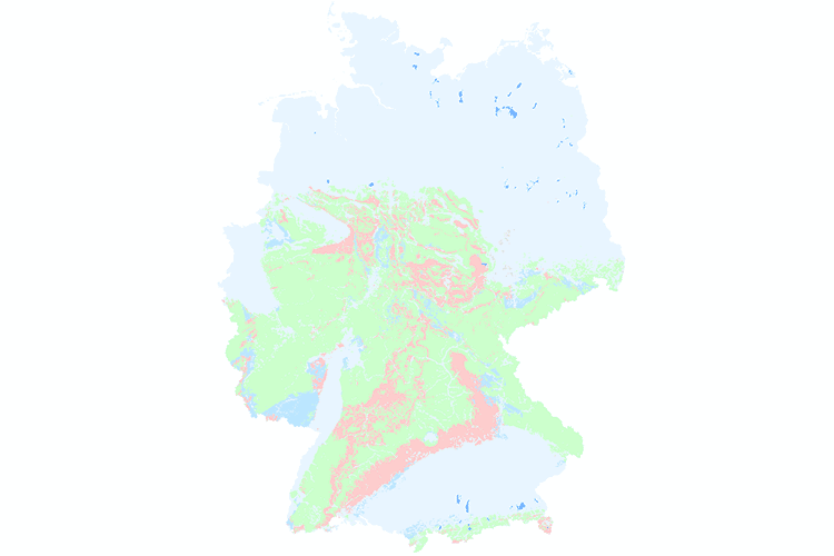
Hydrogeological Map of Germany 1:250,000 (HÜK250)
In order to support the implementation of the European Water Framework Directive (EU-WFD), the German State Geological Surveys (SGD) and the Federal Institute for Geosciences and Natural Resources (BGR) agreed in 2000 to compile a digital hydrogeological map at the scale of 1:200,000 (HÜK200), providing a harmonised survey of the upper groundwater bodies in Germany. The HÜK200 captures hydrogeologically relevant attributes such as consolidation, type of porosity, permeability, type of rock and geochemical classification to describe the hydrogeological characteristics of the rocks of the uppermost aquifers. The geological information on lithology, stratigraphy and genesis of the geological map of Germany 1:200,000 (GÜK200) provided the basic data. This information was evaluated and hydrogeologically interpreted by regional experts of the SGD or replaced and completed by other regional geological and hydrogeological maps and data where necessary. 2019, HÜK200 was migrated to a scale of 1:250.000 (now HÜK250).
|
|
Citation proposal
(2019) . Hydrogeological Map of Germany 1:250,000 (HÜK250). https://gdk.gdi-de.org/geonetwork/srv/api/records/61ac4628-6b62-48c6-89b8-46270819f0d6 |
INSPIRE
Identification
- File identifier
- 61ac4628-6b62-48c6-89b8-46270819f0d6 XML
- Hierarchy level
- dataset Dataset
Online resource
Resource identifier
- code
- afbc7573-d18d-453e-bff3-6477af048770
- Metadata language
- ger German
- Spatial representation type
- Vector
Encoding
- Format
- Shapefile
- Version
- n/a
Projection
Classification of data and services
- Topic category
-
- Geoscientific information
Classification of data and services
Coupled resource
Coupled resource
Classification of data and services
Coupled resource
Coupled resource
Keywords
- GEMET - INSPIRE themes, version 1.0 ( Theme )
-
- Geologie
- Geology
- GEMET - Concepts, version 2.4 ( Theme )
-
- Groundwater
- Grundwasser
- Spatial scope
-
- National
- High-value dataset categories
-
- Erdbeobachtung und Umwelt
Other keywords
- Keywords ( Theme )
-
- Durchlässigkeit
- Geochemischer Gesteinstyp
- Gesteinsart
- Hohlraumart
- Verfestigung
- Leitercharakter
- Lithologie
- Stratigrafie
- HÜK
- HUEK
- HUEK200
- HÜK200
- huek200
- hük200
- HUEK250
- HÜK250
- huek250
- hük250
- Hydrogeologie
- Hydrogeologische Einheiten
- Hydrogeologische Räume
- opendata
- Keywords ( Place )
-
- Deutschland
- germany
Geographic coverage
N
S
E
W
))
Temporal reference
Temporal extent
Temporal extent
- Date ( Publication )
- 2019-03-01
- Date ( Revision )
- 2019-10-16
Quality and validity
- Lineage
- Erarbeitung im Rahmen eines Projektes der Staatlichen Geologischen Dienste der Bundesländer und der BGR auf Grundlage der Geologischen Übersichtskarte 1:200.000 (GÜK200) und weiterer geologischer und hydrogeologischer Karten der Länder.
Conformity
Conformity
Conformity
Conformity
Conformity
Conformity
- Explanation
- siehe dazu die angegebene Durchführungsbestimmung
Restrictions on access and use
- Access constraints
- Allgemeine Geschäftsbedingungen, s. https://www.bgr.bund.de/agb - General Terms and Conditions, s. https://www.bgr.bund.de/agb_en
- Access constraints
- Die bereitgestellten Informationen sind bei Weiterverwendung wie folgt zu zitieren: „Datenquelle: HÜK250 v1.0.3, (C) BGR & SGD 2019“
- Access constraints
- Dieser Datensatz kann gemäß der "Nutzungsbestimmungen für die Bereitstellung von Geodaten des Bundes" (https://sg.geodatenzentrum.de/web_public/gdz/lizenz/geonutzv.pdf) genutzt werden.
- Access constraints
- {"id": "geoNutz/20130319", "name": "Nutzungsbestimmungen für die Bereitstellung von Geodaten des Bundes", "url": "https://sg.geodatenzentrum.de/web_public/gdz/lizenz/geonutzv.pdf", "quelle": "Datenquelle: HÜK250 v1.0.3, (C) BGR & SGD 2019"}
Restrictions on access and use
Responsible organization (s)
Contact for the resource
- Organisation name
- Bundesanstalt für Geowissenschaften und Rohstoffe
- fis.hy@bgr.de
Responsible organization (s)
Contact for the resource
- Organisation name
- Bundesanstalt für Geowissenschaften und Rohstoffe
- fis.hy@bgr.de
Metadata information
Contact for the metadata
- Organisation name
- Bundesanstalt für Geowissenschaften und Rohstoffe (BGR)
- Date stamp
- 2025-03-07
- Metadata language
- German
- Character set
- utf8 UTF8
SDS
Conformance class 1: invocable
Access Point URL
Endpoint URL
Technical specification
Conformance class 2: interoperable
Coordinate reference system
Quality of Service
Access constraints
Limitation
Use constraints
Limitation
Responsible custodian
Contact for the resource
Conformance class 3: harmonized
Overviews
Provided by

Views
61ac4628-6b62-48c6-89b8-46270819f0d6
Access to the portal
Read here the full details and access to the data.
Associated resources
Not available