 www.geodatenkatalog.de (S2F)
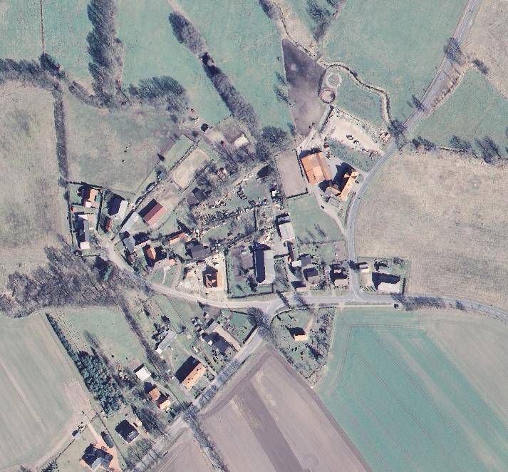
Digitale Orthophotos Bodenauflösung 40 cm
Digitale Orthophotos (DOP) sind verzerrungsfreie und maßstabsgetreue Rasterdaten photographischer Abbildungen der Erdoberfläche. Sie werden aus orientierten Luftbildern und einem Digitalen Höhenmodell abgeleitet.
Der Datensatz umfasst das gesamte Gebiet der Bundesrepublik Deutschland als überlapppungsfreies und lückenloses Mosaik der an den Landesgrenzen beschnittenen DOP der Vermessungsverwaltungen der Länder.
Die DOP stehen als 3-Kanal-Echtfarbbild (Rot-Grün-Blau), als 1-Kanal-Infrarotbild oder als 3-Kanal-Colorinfrarotbild (NIR-Rot_Grün, sog. Falschfarben) zur Verfügung.
|
|
Citation proposal
. Digitale Orthophotos Bodenauflösung 40 cm. Bundesamt für Kartographie und Geodäsie (BKG) https://gdk.gdi-de.org/geonetwork/srv/api/records/6259a665-5877-433a-9a18-9595ed5d9a53 |
INSPIRE
Identification
- File identifier
- 6259a665-5877-433a-9a18-9595ed5d9a53 XML
- Hierarchy level
- dataset Dataset
Online resource
Resource identifier
- Metadata language
- German
- Spatial representation type
- Grid
Encoding
- Format
- TIFF
Projection
Classification of data and services
- Topic category
-
- Imagery base maps earth cover
Classification of data and services
Coupled resource
Coupled resource
Classification of data and services
Coupled resource
Coupled resource
Keywords
- GEMET - INSPIRE themes, version 1.0 ( Theme )
-
- Orthofotografie
- GEMET - Concepts, version 3.1 ( Theme )
Other keywords
- Keywords
-
- Luftbildfotografie
- digitales Orthophoto
- Orthofoto
- DOP
- Befliegung
- Keywords
-
- AdVMIS
Geographic coverage
N
S
E
W
))
Temporal reference
Temporal extent
Temporal extent
- Date ( Creation )
- 2007-01-01T00:00:00.000+01:00
- Date ( Revision )
- 2019-09-01T00:00:00.000+02:00
Quality and validity
- Lineage
- Erfassung, Forführung und Qualifizierung der Daten obliegt den Vermessungsverwaltungen der Länder. Am BKG erfolgt die formal logische Prüfung, die Zusammenführung zu einem überlappungsfreien Mosaik für das gesamte Bundesgebiet und die blattschnittfreie Aufbereitung des Produkts.
- Distance
- 0.4 meter
Conformity
Conformity
Conformity
Conformity
Conformity
Conformity
- Explanation
- see the referenced specification
- Explanation
- see the referenced specification
Restrictions on access and use
- Access constraints
- Es gelten Zugriffsbeschränkungen. Für den Erwerb von Nutzungsrechten wenden Sie sich deshalb bitte an die Zentrale Stelle Geotopographie der AdV (ZSGT) / Dienstleistungszentrum (DLZ) des Bundesamtes für Kartographie und Geodäsie: https://www.bkg.bund.de/DE/Service/Kontakt/kontakt.html.
- Access constraints
- Die Daten sind urheberrechtlich geschützt. Die Daten werden Nutzungsberechtigten nach V GeoBund und V GeoLänder geldleistungsfrei zur Verfügung gestellt. Bitte informieren Sie sich unter nachfolgendem Link über die Details zu Nutzungsbedingungen und Quellenvermerk: https://gdz.bkg.bund.de/index.php/default/hinweise-zu-nutzungsbedingungen-und-quellenvermerken. Der Quellenvermerk ist zu beachten.
Restrictions on access and use
Responsible organization (s)
Contact for the resource
- Organisation name
- Bundesamt für Kartographie und Geodäsie (BKG)
- dlz@bkg.bund.de
- Organisation name
- Bundesamt für Kartographie und Geodäsie (BKG)
- dlz@bkg.bund.de
- Organisation name
- Bundesamt für Kartographie und Geodäsie (BKG)
- mailbox@bkg.bund.de
Metadata information
Contact for the metadata
- Organisation name
- Bundesamt für Kartographie und Geodäsie (BKG)
- dlz@bkg.bund.de
- Date stamp
- 2025-03-10
- Metadata language
- German
- Character set
- UTF8
SDS
Conformance class 1: invocable
Access Point URL
Endpoint URL
Technical specification
Conformance class 2: interoperable
Coordinate reference system
Quality of Service
Access constraints
Limitation
Use constraints
Limitation
Responsible custodian
Contact for the resource
Conformance class 3: harmonized
Overviews
Provided by

Views
6259a665-5877-433a-9a18-9595ed5d9a53
Access to the portal
Read here the full details and access to the data.
Associated resources
Not available