 www.geodatenkatalog.de (S3F)
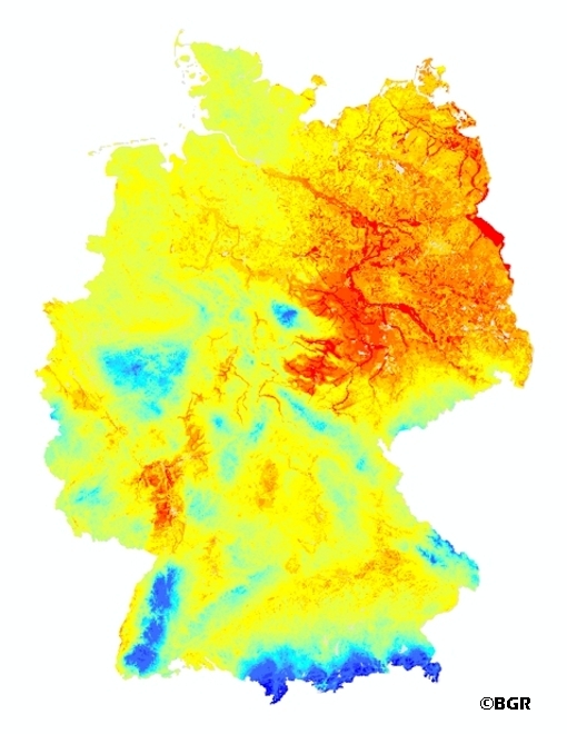
Mean Annual Rate of Percolation from the Soil in Germany
The mean annual rate of percolation from the soil is defined as the amount of water that leaves the soil after consideration of capillary rise. It is expressed in mm/a. Precipitation water infiltrated into the soil after deduction of surface runoff, first stands for the water supply of the vegetation available. Exceeds the water content in the root zone, the field capacity, the water infiltrated force of gravity moved following down and leaves the root zone. Movement of water in the unsaturated zone is affected by infiltration of precipitation and irrigation water, evaporation, absorption of water by plant roots, and ascent of water from the groundwater table by capillary action. The percolating water leaves the soil as interflow, discharging into surface water bodies, or via the groundwater table, recharging the groundwater. Percolating water affects soil formation and the migration and leaching of plant nutrients and contaminants. Knowledge of the rate of percolation is of particular importance for protecting groundwater quality. The mean annual rate of percolation is the balance of precipitation, evapotranspiration and surface runoff.
|
|
Citation proposal
(2003) . Mean Annual Rate of Percolation from the Soil in Germany. https://gdk.gdi-de.org/geonetwork/srv/api/records/641D1613-5E4B-43B6-A0CB-723371356E62 |
Simple
- Alternate title
- SWR1000
- Date ( Creation )
- 2003-01-01
- Date ( Publication )
- 2003-07-01
- Edition
- Version 1.0
- Identifier
- c0af9568-618f-47e2-9344-db996a80637d
Author
- Status
- onGoing On going
Point of contact
Bundesanstalt für Geowissenschaften und Rohstoffe
-
Stange, Florian, Dr.
Stilleweg 2
Hannover
30655
DE
- GEMET - INSPIRE themes, version 1.0 ( Theme )
-
- Boden
- Soil
- GEMET - Concepts, version 2.4 ( Theme )
-
- Bodenschutz
- Bodenwasser
- Evapotranspiration
- Grundwasser
- Grundwasserschutz
- Hydrologie
- Oberflächenabfluss
- Sickerwasser
- Umweltschutz
- Wasser
- Wasserwirtschaft
- Keywords ( Theme )
-
- Bodenbewertung
- Bodeninformationssystem
- Fachinformationssystem
- Geografisches Informationssystem
- Grundwasserneubildung
- Klima
- Sickerwasserrate
- Zwischenabfluss
- Keywords ( Place )
-
- Deutschland
- Access constraints
- Other restrictions
- Use constraints
- Other restrictions
- Other constraints
- Allgemeine Geschäftsbedingungen, s.: https://www.bgr.bund.de/AGB General terms and conditions, s. https://www.bgr.bund.de/AGB_en
- Spatial representation type
- Grid
- Denominator
- 1000000
- Metadata language
- ger German
- Character set
- utf8 UTF8
- Topic category
-
- Geoscientific information
N
S
E
W
))
- Geographic identifier
- Regionalschlüssel / 000000000000
- Distribution format
-
- georef. TIFF (n/a )
- Transfer size
- 18
- OnLine resource
-
SWR1000 (georef. TIFF)
SWR1000 im Format georeferenziertes TIFF
- OnLine resource
-
BGR-Webseite
BGR-Webseite
- OnLine resource
-
Karte im BGR-Geoviewer
Karte im BGR-Geoviewer
- Hierarchy level
- Dataset
- Statement
- BÜK1000N Version 1.3, Klimadaten des DWD und Reliefinformationen des BKG mit einer Rasterweite von 1x1 km.
gmd:MD_Metadata
- File identifier
- 641D1613-5E4B-43B6-A0CB-723371356E62 XML
- Metadata language
- German
- Character set
- utf8 UTF8
- Hierarchy level
- dataset Dataset
- Hierarchy level name
- Boden
- Date stamp
- 2023-08-22
- Metadata standard name
- INSPIRE Metadata Implementing Rules: Technical Guidelines based on EN ISO 19115 and EN ISO 19119
- Metadata standard version
- n/a
Point of contact
Overviews
Provided by

Views
641D1613-5E4B-43B6-A0CB-723371356E62
Access to the portal
Read here the full details and access to the data.
Associated resources
Not available