 www.geodatenkatalog.de (S1L)
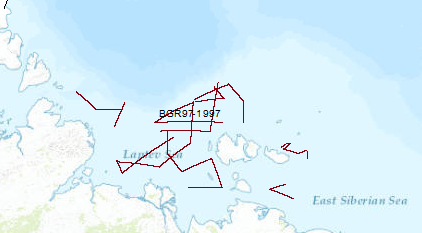
Processed seismic data of Cruise BGR97
The 3rd cooperative BGR/SMNG Arctic cruise was designed to acquire new scietific data for a better understanding of temporal and spatial lithospheric variations during rifting and its influence on the tectonic and structural evolution of the continental crust of the Laptev Sea undergoing extension since at least the Early Tertiary, and for tackling open questions regarding the evolution of the submarine permafrost zone. Although conditions for seismic measurements were worse in 1997 than in 1993 and 1994, along 4,622 km of seismic traverses reflection seismic data and wide angle reflection/refraction data from 23 OBH-(ocean bottom hydrophone) stations were collected in the Laptev and East Siberian Sea. The most prominent rift basin is the Ust' Lena Rift, which is at least 300 km wide at latitude 75°N. The Cenozoic sedimentary cover exceeds 3 km everywhere, increasing up to 14 km at two locations. In the northern part of the shelf, the complex mainly N–S-trending Anisin Basin has a basin fill of up to 10 km thickness. The New Siberian Basin which is located in the northwestern part of the study area shows an up to 9 km thick graben fill. The Laptev Horst crust is locally subdivided into several tilted blocks by deep-reaching faults and there are several half grabens of smaller extent which divide the Laptev Horst into three parts: the North, the South and the East Laptev Horst. A major west dipping listric fault of at least 250 km length separates the Laptev Horst from the Ust' Lena Rift. Results from the seismological investigation indicate that recent extension is concentrated within the narrow rift basins of the eastern Laptev Sea. From wide-angle reflection/refraction seismic measurements the seismic velocities of the crustal layers were estimated along five profiles. The layers with velocities of up to 3.5 km/s apparently consist of predominantly Cenozoic sediments. The sedimentary section showing relatively high seismic velocities of 4.5 to 5.2 km/s might be interpreted as Late Paleozoic to Mesozoic deposits or overcompacted/cemented syn-rift deposits. In the eastern shelf area a layer beneath the acoustic basement was interpreted to represent Ordovician to Early Mesozoic carbonates. The lower crust in the area under study shows relatively uniform seismic velocities of about 6.0-6.8 km/s and the velocities estimated for the crust-mantle transition are in the range of 8.0 to 8.2 km/s. The origin of a several 100 m thick layer with a relative high velocity of 3 to 3.5 km/s directly beneath the seafloor was inferred as sub-sea permafrost.
|
|
Citation proposal
. Processed seismic data of Cruise BGR97. https://gdk.gdi-de.org/geonetwork/srv/api/records/66c1d069-4e65-4f37-aef8-a42948d9edf7 |
INSPIRE
Identification
- File identifier
- 66c1d069-4e65-4f37-aef8-a42948d9edf7 XML
- Hierarchy level
- Dataset
Online resource
Resource identifier
- code
- 52ab9843-d1ee-4b65-a202-38b816fc6093
- Metadata language
- English
- Spatial representation type
- Vector
Encoding
- Format
- Shapefile
- Version
- n/a
Projection
Classification of data and services
- Topic category
-
- Geoscientific information
Classification of data and services
Coupled resource
Coupled resource
Classification of data and services
Coupled resource
Coupled resource
Keywords
- GEMET - INSPIRE themes, version 1.0 ( Theme )
-
- Geologie
- geology
- GEMET - Concepts, version 2.4 ( Theme )
-
- geophysics
- Geophysik
- raw material
- Rohstoff
Other keywords
- Keywords ( Theme )
-
- Marine geology
- Meeresgeologie
- Seismics
- Seismik
- Two-dimensional seismic reflection
- zweidimensionale Reflektionsseismik
- MSSP
- Keywords ( Place )
-
- Laptev Sea
- Laptevsee
Geographic coverage
N
S
E
W
))
Temporal reference
Temporal extent
Temporal extent
- Date ( Creation )
- 1997-10-15
Quality and validity
- Lineage
- During the period from 20th of august to 15th of October 1997 BGR aquired seismic lines in the Laptev Sea. The lines BGR97-01, BGR97-02, BGR97-03, BGR97-04, BGR97-04A, BGR97-04B, BGR97-05, BGR97-06, BGR97-07, BGR97-08 are processed (stack) data and lines BGR97-09, BGR97-10, BGR97-11, BGR97-12, BGR97-13, BGR97-14, BGR97-15, BGR97-15A, BGR97-16, BGR97-17, BGR97-17A, BGR97-17B, BGR97-17C, BGR97-18, BGR97-19, BGR97-19A, BGR97-20, BGR97-20A, BGR97-21, BGR97-22, BGR97-23, BGR97-24, BGR97-25, BGR97-26, BGR97-27 are processed (migrated) data.
Conformity
Conformity
Conformity
Conformity
Conformity
Conformity
- Explanation
- siehe dazu die angegebene Durchführungsbestimmung
Restrictions on access and use
- Access constraints
- Allgemeine Geschäftsbedingungen, siehe https://www.bgr.bund.de/AGB - General terms and conditions, see https://www.bgr.bund.de/AGB_en. Die bereitgestellten Informationen sind bei Weiterverwendung wie folgt zu zitieren: Datenquelle: BGR97, (c) BGR, Hannover, 1997
Restrictions on access and use
Responsible organization (s)
Contact for the resource
- Organisation name
- Federal Institute for Geosciences and Natural Resources
- Marine_Seismik@bgr.de
Responsible organization (s)
Contact for the resource
- Organisation name
- Federal Institute for Geosciences and Natural Resources
- Marine_Seismik@bgr.de
Metadata information
Contact for the metadata
- Organisation name
- Bundesanstalt für Geowissenschaften und Rohstoffe (BGR)
- Date stamp
- 2023-11-14
- Metadata language
- English
- Character set
- UTF8
SDS
Conformance class 1: invocable
Access Point URL
Endpoint URL
Technical specification
Conformance class 2: interoperable
Coordinate reference system
Quality of Service
Access constraints
Limitation
Use constraints
Limitation
Responsible custodian
Contact for the resource
Conformance class 3: harmonized
Overviews
Provided by

Views
66c1d069-4e65-4f37-aef8-a42948d9edf7
Access to the portal
Read here the full details and access to the data.
Associated resources
Not available