 www.geodatenkatalog.de (S3L)
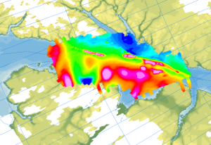
Helicopter-borne Magnetics NARES I (Robeson Channel)
During the German-Canadian Nares Strait Expedition in 2001, an aeromagnetic survey was carried out across the northern part of the Nares Strait including the Hall Basin, Judge Daly Promontory and in Robeson Channel in cooperation with the Canadian GSC. The aim of the research was to detect and localize the Wegener Fault, a transform fault between Ellesmere Island and NW Greenland, which is closely linked to the opening of the North Atlantic and the Arctic Ocean. The helicopter-borne magnetic survey NARES I (Robeson Channel) was carried out with a flight line spacing of 2 km, and control profiles were flown every 10 km. During the expedition, 5470 km of line data were collected. The aeromagnetic data were recorded by a magnetometer, which was towed approx. 25 m beneath the helicopter and recorded at a constant altitude of 305 m (1000 ft) above ground.
|
|
Citation proposal
(2023) . Helicopter-borne Magnetics NARES I (Robeson Channel). https://gdk.gdi-de.org/geonetwork/srv/api/records/6a024df8-519d-48c6-baf3-1fb71b071b85 |
INSPIRE
Identification
- File identifier
- 6a024df8-519d-48c6-baf3-1fb71b071b85 XML
- Hierarchy level
- Dataset
Online resource
Resource identifier
- code
- d9eb00fe-93f2-ee92-1102-eb9081d484c4
- Metadata language
- English
Encoding
- Format
- GeoTIFF
- Version
- n/a
- Format
- shp
- Version
- n/a
- Format
- WMS
- Version
- OGC:WMS1.3.0
Projection
Classification of data and services
- Topic category
-
- Geoscientific information
Classification of data and services
Coupled resource
Coupled resource
Classification of data and services
Coupled resource
Coupled resource
Keywords
- GEMET - INSPIRE themes, version 1.0 ( Theme )
-
- Geologie
- Geology
- GEMET - Concepts, version 2.4 ( Theme )
-
- Geophysik
Other keywords
- Keywords ( Theme )
-
- Aerogeophysik
- Aeromagnetik
- Anomalien des erdmagnetischen Feldes
- Airborne geophysics
- helicopter-borne /fixed-wing magnetics
- anomalies of the Earth’s magnetic field
- Keywords ( Place )
-
- Arktis
- Arctic
- Nordpolargebiet
- North Polar
- Nares Strait
Geographic coverage
N
S
E
W
))
Temporal reference
Temporal extent
Temporal extent
- Date ( Publication )
- 2023-02-22
Quality and validity
- Lineage
- The aeromagnetic data were collected by GSC Canada and BGR as part of the NARES I expeditions between Ellesmere Island and NW Greenland.
Conformity
Conformity
Conformity
Conformity
Conformity
Conformity
Restrictions on access and use
- Access constraints
- Allgemeine Geschäftsbedingungen, siehe https://www.bgr.bund.de/AGB - General terms and conditions, see https://www.bgr.bund.de/AGB_en. Die bereitgestellten Informationen sind bei Weiterverwendung wie folgt zu zitieren: Datenquelle: AeromagNARES, (c) BGR, Hannover, 2023
Restrictions on access and use
Responsible organization (s)
Contact for the resource
- Organisation name
- Bundesanstalt für Geowissenschaften und Rohstoffe (BGR)
- polargeologie@bgr.de
Responsible organization (s)
Contact for the resource
- Organisation name
- Bundesanstalt für Geowissenschaften und Rohstoffe (BGR)
- polargeologie@bgr.de
Metadata information
Contact for the metadata
- Organisation name
- Bundesanstalt für Geowissenschaften und Rohstoffe (BGR)
- Date stamp
- 2025-04-07
- Metadata language
- English
- Character set
- UTF8
SDS
Conformance class 1: invocable
Access Point URL
Endpoint URL
Technical specification
Conformance class 2: interoperable
Coordinate reference system
Quality of Service
Access constraints
Limitation
Use constraints
Limitation
Responsible custodian
Contact for the resource
Conformance class 3: harmonized
Overviews
Provided by

Views
6a024df8-519d-48c6-baf3-1fb71b071b85
Access to the portal
Read here the full details and access to the data.
Associated resources
Not available